TopoQuest Logo
Do you find TopoQuest useful?
Help keep TopoQuest running and adding new maps/features by donating!
Bitcoin:  19c7KJd3qBynnjoSw5npx9KScwjBe4ifkT
Litecoin:  LXs6TkuXGGXo1vDsWCkWVdjQX94eUKd6ui
Home View Maps Find Maps Find Places Resources & Links


Tamms, Illinois Topographic Map

USGS Map Title: Tamms, IL
USGS Map MRC: 37089B3
DRG (GeoTIFF) Download: o37089b3.tif


Neighboring USGS Topographic Map Quads:


  McClure, IL  
37089C4
 

  Mill Creek, IL  
37089C3
 

  Dongola, IL  
37089C2
 

  Thebes, IL  
37089B4
 

  Tamms, IL  
37089B3
 

  Pulaski, IL  
37089B2
 

  Thebes SW, MO  
37089A4
 

  Cache, IL  
37089A3
 

  Cairo, IL  
37089A2


Map MRC Location:

N38°
W90°
N38°
W89°
H8 H7 H6 H5 H4 H3 H2 H1
G8 G7 G6 G5 G4 G3 G2 G1
F8 F7 F6 F5 F4 F3 F2 F1
E8 E7 E6 E5 E4 E3 E2 E1
D8 D7 D6 D5 D4 D3 D2 D1
C8 C7 C6 C5 C4 C3 C2 C1
B8 B7 B6 B5 B4 B3 B2 B1
A8 A7 A6 A5 A4 A3 A2 A1
N37°
W90°
N37°
W89°

Tamms, IL USGS 1:24K Topographic Map Preview:
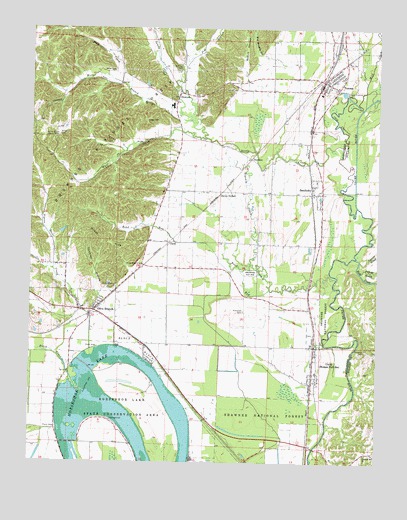
Tamms, IL USGS Topographic Map
Click on map above to begin viewing in our Map Viewer.

This topographic map contains these locations and features:
Feature Name Type Latitude Longitude GNIS ID View Map
Alexander CountyCivilN37.1916°W89.3376°424203View Map
Alexander County Emergency Medical ServicesBuildingN37.1671°W89.3489°2673828View Map
Ambeer CreekStreamN37.2345°W89.3434°424569View Map
Beech HollowValleyN37.2362°W89.2987°424621View Map
Big Brushy HollowValleyN37.2423°W89.2939°424639View Map
Black CreekStreamN37.1456°W89.3556°424649View Map
Boar CreekStreamN37.1842°W89.2579°424658View Map
Childers CemeteryCemeteryN37.2178°W89.3487°424744View Map
ClankPopulated PlaceN37.1884°W89.3251°424746View Map
Coakley HollowValleyN37.1735°W89.3501°424757View Map
Cypress SloughStreamN37.1834°W89.2565°424804View Map
Davey SwitchLocaleN37.2020°W89.3079°424818View Map
DawleysPopulated PlaceN37.2126°W89.2962°424819View Map
DiswoodPopulated PlaceN37.2314°W89.3229°424831View Map
Egyptian Senior High SchoolSchoolN37.2278°W89.3245°1808563View Map
Gilson HillsSummitN37.1889°W89.3479°424920View Map
Hargis CemeteryCemeteryN37.2237°W89.3342°424964View Map
Hodges CemeteryCemeteryN37.1630°W89.2727°2047075View Map
Hodges ParkPopulated PlaceN37.1573°W89.2720°1736141View Map
Hogskin BottomsSwampN37.2234°W89.2938°1736142View Map
Hogskin CreekStreamN37.1798°W89.2676°425002View Map
Honey School (historical)SchoolN37.2226°W89.3720°1736143View Map
Honey School Lookout TowerTowerN37.2189°W89.3656°425009View Map
Horseshoe LakeLakeN37.1383°W89.3413°425012View Map
Horseshoe Lake Fire DepartmentBuildingN37.1669°W89.3493°2640720View Map
Horseshoe Lake Nature PreserveParkN37.1259°W89.3265°2011606View Map
Horseshoe Lake State Conservation AreaParkN37.1306°W89.3331°425993View Map
Jackson CreekStreamN37.2348°W89.2551°425054View Map
Jim BranchStreamN37.2234°W89.3184°425057View Map
McCrite CemeteryCemeteryN37.2381°W89.3229°425183View Map
Mill CreekStreamN37.2276°W89.2554°425196View Map
Miller CemeteryCemeteryN37.2195°W89.3654°425199View Map
Miller CemeteryCemeteryN37.2378°W89.3459°425200View Map
Old ChannelStreamN37.1987°W89.2576°425271View Map
Olive BranchPopulated PlaceN37.1687°W89.3517°425282View Map
Olive Branch CemeteryCemeteryN37.1709°W89.3545°1821616View Map
Olive Branch Census Designated PlaceCensusN37.1755°W89.3517°2583440View Map
Olive Branch Election PrecinctCivilN37.1574°W89.3635°1928583View Map
Olive Branch Post OfficePost OfficeN37.1694°W89.3513°1808569View Map
Pigeon Roost CreekStreamN37.1556°W89.3529°425330View Map
Pleasant Hill ChurchChurchN37.1276°W89.2540°425337View Map
Pulaski SloughStreamN37.1803°W89.2565°425355View Map
Richwood CemeteryCemeteryN37.1687°W89.2984°425379View Map
Road RunStreamN37.1751°W89.2890°425388View Map
SanduskyPopulated PlaceN37.2026°W89.2723°425447View Map
Sandusky Election PrecinctCivilN37.1933°W89.3055°1928642View Map
Sandy CreekStreamN37.2164°W89.2626°425448View Map
Sandy Creek ChurchChurchN37.2320°W89.3231°1736156View Map
Silica MineMineN37.1820°W89.3365°425490View Map
Solomon CemeteryCemeteryN37.1584°W89.2545°425500View Map
TammsPopulated PlaceN37.2351°W89.2701°425548View Map
Tamms Police DepartmentBuildingN37.2357°W89.2698°2758915View Map
Tamms Post OfficePost OfficeN37.2339°W89.2705°2788388View Map
Tamms Volunteer Fire DepartmentBuildingN37.2347°W89.2719°2640184View Map
Uninty CemeteryCemeteryN37.1626°W89.2731°2047076View Map
UnityPopulated PlaceN37.1498°W89.2729°425589View Map
Village of TammsCivilN37.2415°W89.2713°2399951View Map
West Branch Sandy CreekStreamN37.2234°W89.3184°425627View Map
Wolf CreekStreamN37.2184°W89.3131°425646View Map

Note: Coordinates in the location and feature list above are referenced to NAD83 datum.


Copyright (C) 2008-2024 Ryan Niemi / Sunset Dynamics ... All Rights Reserved