TopoQuest Logo
Do you find TopoQuest useful?
Help keep TopoQuest running and adding new maps/features by donating!
Bitcoin:  19c7KJd3qBynnjoSw5npx9KScwjBe4ifkT
Litecoin:  LXs6TkuXGGXo1vDsWCkWVdjQX94eUKd6ui
Home View Maps Find Maps Find Places Resources & Links


Girard NE, South Carolina Topographic Map

USGS Map Title: Girard NE, SC
USGS Map MRC: 33081B5
DRG (GeoTIFF) Download: o33081b5.tif


Neighboring USGS Topographic Map Quads:


  New Ellenton SW, SC  
33081C6
 

  New Ellenton SE, SC  
33081C5
 

  Long Branch, SC  
33081C4
 

  Girard NW, SC  
33081B6
 

  Girard NE, SC  
33081B5
 

  Snelling, SC  
33081B4
 

  Girard, GA  
33081A6
 

  Millett, SC  
33081A5
 

  Martin, SC  
33081A4


Map MRC Location:

N34°
W82°
N34°
W81°
H8 H7 H6 H5 H4 H3 H2 H1
G8 G7 G6 G5 G4 G3 G2 G1
F8 F7 F6 F5 F4 F3 F2 F1
E8 E7 E6 E5 E4 E3 E2 E1
D8 D7 D6 D5 D4 D3 D2 D1
C8 C7 C6 C5 C4 C3 C2 C1
B8 B7 B6 B5 B4 B3 B2 B1
A8 A7 A6 A5 A4 A3 A2 A1
N33°
W82°
N33°
W81°

Girard NE, SC USGS 1:24K Topographic Map Preview:
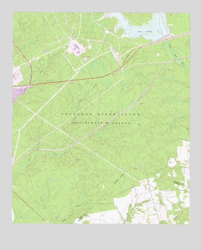
Girard NE, SC USGS Topographic Map
Click on map above to begin viewing in our Map Viewer.

This topographic map contains these locations and features:
Feature Name Type Latitude Longitude GNIS ID View Map
Ashley Grove School (historical)SchoolN33.2057°W81.6193°1235409View Map
Donora (historical)Populated PlaceN33.2210°W81.5165°1235456View Map
Dunbar CemeteryCemeteryN33.1838°W81.5340°1235460View Map
Dunbarton (historical)Populated PlaceN33.1960°W81.5390°1235461View Map
Dunbarton Fire TowerLocaleN33.2101°W81.5901°1731900View Map
Gum Pond Church (historical)ChurchN33.1546°W81.5407°1233124View Map
Gum Pond School (historical)SchoolN33.1546°W81.5407°1233125View Map
Kline-Snelling DivisionCivilN33.2065°W81.5190°1938319View Map
Meyers Mill (historical)LocaleN33.1668°W81.6009°1235508View Map
Meyers Mill SidingLocaleN33.1688°W81.5982°1731901View Map
Mission Church (historical)ChurchN33.1946°W81.5584°1235509View Map
Neds Branch Church (historical)ChurchN33.1771°W81.5457°1235515View Map
Neds Branch School (historical)SchoolN33.1774°W81.5457°1235516View Map
Par PondReservoirN33.2357°W81.5173°1225289View Map
Pleasant Mount Church (historical)ChurchN33.1638°W81.5332°1235525View Map
Roundtree School (historical)SchoolN33.1657°W81.5268°1242275View Map
Sanders CemeteryCemeteryN33.1626°W81.5804°1235542View Map
Singleton CemeteryCemeteryN33.1963°W81.5354°1235552View Map
Spring Branch Church (historical)ChurchN33.1696°W81.5948°1235554View Map
Spring Branch School (historical)SchoolN33.1696°W81.5948°1235555View Map
Steel Creek Church (historical)ChurchN33.1838°W81.5546°1242276View Map
Thomas Grove Church (historical)ChurchN33.1926°W81.5087°1235561View Map
Thomas Grove Church (historical)ChurchN33.2282°W81.5348°1242278View Map
Thomas Grove School (historical)SchoolN33.1929°W81.5084°1235562View Map
Walker CemeteryCemeteryN33.1618°W81.5148°1227375View Map
Williams CemeteryCemeteryN33.1285°W81.5946°1235570View Map
Williams CemeteryCemeteryN33.1574°W81.5365°1235571View Map
Woods CemeteryCemeteryN33.1813°W81.5020°1235577View Map

Note: Coordinates in the location and feature list above are referenced to NAD83 datum.


Copyright (C) 2008-2025 Ryan Niemi / Sunset Dynamics ... All Rights Reserved