TopoQuest Logo
Do you find TopoQuest useful?
Help keep TopoQuest running and adding new maps/features by donating!
Bitcoin:  19c7KJd3qBynnjoSw5npx9KScwjBe4ifkT
Litecoin:  LXs6TkuXGGXo1vDsWCkWVdjQX94eUKd6ui
Home View Maps Find Maps Find Places Resources & Links


Mintonsville, North Carolina Topographic Map

USGS Map Title: Mintonsville, NC
USGS Map MRC: 36076C6
DRG (GeoTIFF) Download: o36076c6.tif


Neighboring USGS Topographic Map Quads:


  Gatesville, NC  
36076D7
 

  Merchants Millpond, NC  
36076D6
 

  Sunbury, NC  
36076D5
 

  Harrellsville, NC  
36076C7
 

  Mintonsville, NC  
36076C6
 

  Hobbsville, NC  
36076C5
 

  Colerain, NC  
36076B7
 

  Valhalla, NC  
36076B6
 

  Center Hill, NC  
36076B5


Map MRC Location:

N37°
W77°
N37°
W76°
H8 H7 H6 H5 H4 H3 H2 H1
G8 G7 G6 G5 G4 G3 G2 G1
F8 F7 F6 F5 F4 F3 F2 F1
E8 E7 E6 E5 E4 E3 E2 E1
D8 D7 D6 D5 D4 D3 D2 D1
C8 C7 C6 C5 C4 C3 C2 C1
B8 B7 B6 B5 B4 B3 B2 B1
A8 A7 A6 A5 A4 A3 A2 A1
N36°
W77°
N36°
W76°

Mintonsville, NC USGS 1:24K Topographic Map Preview:
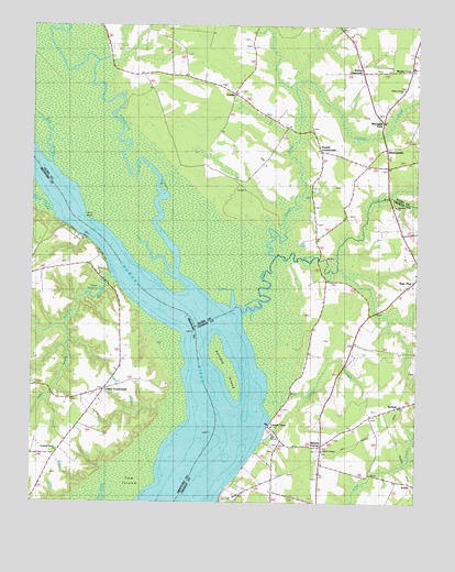
Mintonsville, NC USGS Topographic Map
Click on map above to begin viewing in our Map Viewer.

This topographic map contains these locations and features:
Feature Name Type Latitude Longitude GNIS ID View Map
Beef CreekStreamN36.3382°W76.7436°1000856View Map
Bennetts CreekStreamN36.3052°W76.6972°1027377View Map
Bond LandingLocaleN36.3352°W76.7077°1003356View Map
Cannon FerryPopulated PlaceN36.2704°W76.6722°1025218View Map
CarterPopulated PlaceN36.3574°W76.6844°1027388View Map
Catherine CreekStreamN36.3004°W76.6838°1025226View Map
ChowanPopulated PlaceN36.2665°W76.6677°1019673View Map
Christian Harbor ChurchChurchN36.2638°W76.7413°1000857View Map
Deep Swamp BranchStreamN36.3090°W76.7233°984103View Map
Dinkerderry Landing (historical)LocaleN36.3065°W76.6722°1002689View Map
Dogwood Landing (historical)LocaleN36.3229°W76.7394°1003374View Map
Fletchers ChapelChurchN36.3485°W76.6655°1003353View Map
Goose CreekStreamN36.3260°W76.7427°1000921View Map
Holiday IslandIslandN36.2843°W76.6852°1025388View Map
Honey Pot SwampSwampN36.3747°W76.7365°1003354View Map
Horn PointCapeN36.3252°W76.7330°1000855View Map
Hurdle LandingLocaleN36.3232°W76.6697°1003357View Map
Hutson CornerPopulated PlaceN36.2652°W76.6549°1020870View Map
IcariaPopulated PlaceN36.2560°W76.6272°1020876View Map
Indian Old Field (historical)LocaleN36.3127°W76.6697°1002688View Map
Lloyd CrossroadsPopulated PlaceN36.2796°W76.7252°1021253View Map
MintonsvillePopulated PlaceN36.3429°W76.6358°1021494View Map
Mitchells ForkPopulated PlaceN36.3502°W76.6361°1025550View Map
Mount Pleasant Wharf (historical)LocaleN36.3196°W76.7322°1003375View Map
Mount RosePopulated PlaceN36.2563°W76.6705°1021558View Map
Mount RoseLocaleN36.2557°W76.6713°1002696View Map
Muddy CrossPopulated PlaceN36.3638°W76.6274°1021580View Map
Old Chapel CrossroadsPopulated PlaceN36.3382°W76.6347°1021730View Map
Oldtown LandingLocaleN36.3149°W76.6622°1003358View Map
Powell CrossroadsPopulated PlaceN36.3421°W76.6566°1022068View Map
Roberts LandingLocaleN36.3532°W76.7211°1003355View Map
RylandLocaleN36.2754°W76.6302°1000849View Map
Stumpy CreekStreamN36.2763°W76.6738°995625View Map
Taylor MillpondReservoirN36.3037°W76.7290°1026048View Map
Taylor Wharf (historical)LocaleN36.3146°W76.7263°1003376View Map
The Harbor (historical)LocaleN36.2807°W76.6997°1003377View Map
Township 3-UpperCivilN36.2838°W76.6300°1026552View Map
Township of MintonsvilleCivilN36.3505°W76.6598°1026707View Map
Trotman CreekStreamN36.3143°W76.6705°1025755View Map
Walton CrossroadsPopulated PlaceN36.3635°W76.6433°1023112View Map
Walton Grove ChurchChurchN36.3588°W76.6294°1000851View Map
Warwick ChurchChurchN36.3277°W76.6316°1000850View Map
Warwick CreekStreamN36.3143°W76.6705°1027476View Map
Welchs ChapelChurchN36.2640°W76.6552°1000848View Map
Welsh PondReservoirN36.3102°W76.6516°996954View Map
Woodleys WharfLocaleN36.2629°W76.6766°1002698View Map

Note: Coordinates in the location and feature list above are referenced to NAD83 datum.


Copyright (C) 2008-2025 Ryan Niemi / Sunset Dynamics ... All Rights Reserved