TopoQuest Logo
Do you find TopoQuest useful?
Help keep TopoQuest running and adding new maps/features by donating!
Bitcoin:  19c7KJd3qBynnjoSw5npx9KScwjBe4ifkT
Litecoin:  LXs6TkuXGGXo1vDsWCkWVdjQX94eUKd6ui
Home View Maps Find Maps Find Places Resources & Links


Colerain, North Carolina Topographic Map

USGS Map Title: Colerain, NC
USGS Map MRC: 36076B7
DRG (GeoTIFF) Download: o36076b7.tif


Neighboring USGS Topographic Map Quads:


  Ahoskie, NC  
36076C8
 

  Harrellsville, NC  
36076C7
 

  Mintonsville, NC  
36076C6
 

  Powellsville, NC  
36076B8
 

  Colerain, NC  
36076B7
 

  Valhalla, NC  
36076B6
 

  Windsor North, NC  
36076A8
 

  Merry Hill, NC  
36076A7
 

  Edenhouse, NC  
36076A6


Map MRC Location:

N37°
W77°
N37°
W76°
H8 H7 H6 H5 H4 H3 H2 H1
G8 G7 G6 G5 G4 G3 G2 G1
F8 F7 F6 F5 F4 F3 F2 F1
E8 E7 E6 E5 E4 E3 E2 E1
D8 D7 D6 D5 D4 D3 D2 D1
C8 C7 C6 C5 C4 C3 C2 C1
B8 B7 B6 B5 B4 B3 B2 B1
A8 A7 A6 A5 A4 A3 A2 A1
N36°
W77°
N36°
W76°

Colerain, NC USGS 1:24K Topographic Map Preview:
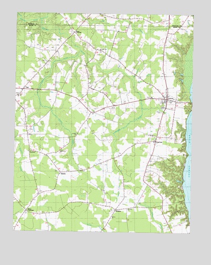
Colerain, NC USGS Topographic Map
Click on map above to begin viewing in our Map Viewer.

This topographic map contains these locations and features:
Feature Name Type Latitude Longitude GNIS ID View Map
Barbeque SwampStreamN36.1524°W76.8630°1003999View Map
Bess LandingLocaleN36.1468°W76.7547°1006451View Map
Bethany ChurchChurchN36.1340°W76.8050°1004415View Map
Bull BranchStreamN36.2127°W76.7922°1004403View Map
Bull Pond PointCapeN36.1699°W76.7516°1004411View Map
Cabin BranchStreamN36.2182°W76.8036°1004402View Map
ColerainPopulated PlaceN36.2013°W76.7686°1019733View Map
Colerain Baptist ChurchChurchN36.2031°W76.7676°2505859View Map
Colerain BeachPopulated PlaceN36.1965°W76.7538°1019734View Map
Colerain Post OfficePost OfficeN36.2015°W76.7688°2773953View Map
Colerain Rescue SquadBuildingN36.2006°W76.7686°2720562View Map
Colerain Volunteer Fire DepartmentBuildingN36.2015°W76.7683°2638610View Map
Cypress SwampStreamN36.2288°W76.8308°1025276View Map
Glovers CrossroadsPopulated PlaceN36.2393°W76.8336°1025963View Map
Goose PondPopulated PlaceN36.1779°W76.7750°1004410View Map
Goose Pond LandingLocaleN36.1724°W76.7538°1006438View Map
Hillcrest CemeteryCemeteryN36.1940°W76.7713°1004408View Map
Long BranchStreamN36.2465°W76.8719°1025498View Map
Mars Hill ChurchChurchN36.2032°W76.8736°1004405View Map
Marys BeachPopulated PlaceN36.1618°W76.7541°1003553View Map
Mount Olive ChurchChurchN36.1807°W76.8313°1004407View Map
Mount Olivet ChurchChurchN36.1382°W76.7938°1004414View Map
New Holly Grove ChurchChurchN36.2288°W76.8152°1004493View Map
Peele BranchStreamN36.2113°W76.7913°1004404View Map
PerrytownPopulated PlaceN36.1379°W76.8041°1006326View Map
Perrytown Fire DepartmentBuildingN36.1378°W76.8001°2639232View Map
Point Comfort LandingLocaleN36.1513°W76.7558°1006426View Map
RosemeadPopulated PlaceN36.1802°W76.8661°1006354View Map
Town of ColerainCivilN36.2016°W76.7664°2406293View Map
Township of ColerainCivilN36.1908°W76.8392°1026412View Map
TrapPopulated PlaceN36.2068°W76.8708°1022979View Map
Trap Volunteer Fire DepartmentBuildingN36.2056°W76.8693°2638311View Map
WakelonPopulated PlaceN36.1588°W76.8436°1023095View Map
Wakelon ChurchChurchN36.1599°W76.8288°1004413View Map
West Colerain SchoolSchoolN36.2027°W76.7786°1023508View Map
Whites BeachPopulated PlaceN36.1549°W76.7552°1003552View Map
Whites CrossroadsPopulated PlaceN36.1371°W76.8658°1004412View Map
Wynns Grove ChurchChurchN36.1710°W76.8425°1004406View Map
Zion Hill ChurchChurchN36.1804°W76.7766°1004409View Map

Note: Coordinates in the location and feature list above are referenced to NAD83 datum.


Copyright (C) 2008-2025 Ryan Niemi / Sunset Dynamics ... All Rights Reserved