TopoQuest Logo
Do you find TopoQuest useful?
Help keep TopoQuest running and adding new maps/features by donating!
Bitcoin:  19c7KJd3qBynnjoSw5npx9KScwjBe4ifkT
Litecoin:  LXs6TkuXGGXo1vDsWCkWVdjQX94eUKd6ui
Home View Maps Find Maps Find Places Resources & Links


Center Hill, North Carolina Topographic Map

USGS Map Title: Center Hill, NC
USGS Map MRC: 36076B5
DRG (GeoTIFF) Download: o36076b5.tif


Neighboring USGS Topographic Map Quads:


  Mintonsville, NC  
36076C6
 

  Hobbsville, NC  
36076C5
 

  Chapanoke, NC  
36076C4
 

  Valhalla, NC  
36076B6
 

  Center Hill, NC  
36076B5
 

  Hertford, NC  
36076B4
 

  Edenhouse, NC  
36076A6
 

  Edenton, NC  
36076A5
 

  Yeopim River, NC  
36076A4


Map MRC Location:

N37°
W77°
N37°
W76°
H8 H7 H6 H5 H4 H3 H2 H1
G8 G7 G6 G5 G4 G3 G2 G1
F8 F7 F6 F5 F4 F3 F2 F1
E8 E7 E6 E5 E4 E3 E2 E1
D8 D7 D6 D5 D4 D3 D2 D1
C8 C7 C6 C5 C4 C3 C2 C1
B8 B7 B6 B5 B4 B3 B2 B1
A8 A7 A6 A5 A4 A3 A2 A1
N36°
W77°
N36°
W76°

Center Hill, NC USGS 1:24K Topographic Map Preview:
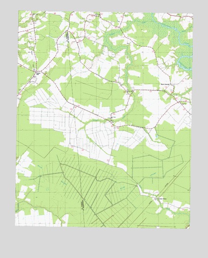
Center Hill, NC USGS Topographic Map
Click on map above to begin viewing in our Map Viewer.

This topographic map contains these locations and features:
Feature Name Type Latitude Longitude GNIS ID View Map
Anderson ChurchChurchN36.1974°W76.5066°1004344View Map
Bagley SwampStreamN36.2388°W76.5088°1004345View Map
Beach SpringsPopulated PlaceN36.2093°W76.5147°1018992View Map
Bear SwampSwampN36.1477°W76.5147°1025119View Map
Bear SwampSwampN36.1477°W76.5786°980738View Map
Center HillPopulated PlaceN36.2152°W76.6108°1019593View Map
Chowan CountyCivilN36.1266°W76.6021°1025822View Map
Dwight (historical)LocaleN36.2390°W76.5888°1003345View Map
Goodings MillpondReservoirN36.2377°W76.5580°1003346View Map
Goodwin CreekStreamN36.2449°W76.5272°1025337View Map
Great Hope ChurchChurchN36.1885°W76.5577°1004342View Map
Happy Home ChurchChurchN36.2482°W76.6144°1004348View Map
Hunters Fork ChurchChurchN36.2479°W76.5663°1004346View Map
Piney Grove ChurchChurchN36.2085°W76.6163°1004347View Map
Saunders Grove ChurchChurchN36.2046°W76.5463°1004343View Map
Township of HertfordCivilN36.1740°W76.5312°1027041View Map
Tyner Post OfficePost OfficeN36.2148°W76.6114°1023358View Map
Yeopim StationPopulated PlaceN36.1429°W76.5238°1025813View Map

Note: Coordinates in the location and feature list above are referenced to NAD83 datum.


Copyright (C) 2008-2024 Ryan Niemi / Sunset Dynamics ... All Rights Reserved