TopoQuest Logo
Do you find TopoQuest useful?
Help keep TopoQuest running and adding new maps/features by donating!
Bitcoin:  19c7KJd3qBynnjoSw5npx9KScwjBe4ifkT
Litecoin:  LXs6TkuXGGXo1vDsWCkWVdjQX94eUKd6ui
Home View Maps Find Maps Find Places Resources & Links


Valhalla, North Carolina Topographic Map

USGS Map Title: Valhalla, NC
USGS Map MRC: 36076B6
DRG (GeoTIFF) Download: o36076b6.tif


Neighboring USGS Topographic Map Quads:


  Harrellsville, NC  
36076C7
 

  Mintonsville, NC  
36076C6
 

  Hobbsville, NC  
36076C5
 

  Colerain, NC  
36076B7
 

  Valhalla, NC  
36076B6
 

  Center Hill, NC  
36076B5
 

  Merry Hill, NC  
36076A7
 

  Edenhouse, NC  
36076A6
 

  Edenton, NC  
36076A5


Map MRC Location:

N37°
W77°
N37°
W76°
H8 H7 H6 H5 H4 H3 H2 H1
G8 G7 G6 G5 G4 G3 G2 G1
F8 F7 F6 F5 F4 F3 F2 F1
E8 E7 E6 E5 E4 E3 E2 E1
D8 D7 D6 D5 D4 D3 D2 D1
C8 C7 C6 C5 C4 C3 C2 C1
B8 B7 B6 B5 B4 B3 B2 B1
A8 A7 A6 A5 A4 A3 A2 A1
N36°
W77°
N36°
W76°

Valhalla, NC USGS 1:24K Topographic Map Preview:
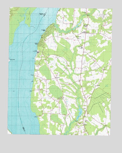
Valhalla, NC USGS Topographic Map
Click on map above to begin viewing in our Map Viewer.

This topographic map contains these locations and features:
Feature Name Type Latitude Longitude GNIS ID View Map
Arrowhead BeachPopulated PlaceN36.2232°W76.7094°1025933View Map
Ballards BridgeBridgeN36.2438°W76.6549°1003845View Map
Ballards Bridge ChurchChurchN36.2454°W76.6563°1003732View Map
Bandon ChapelChurchN36.2204°W76.7080°1026272View Map
Bass LandingLocaleN36.1777°W76.7191°1003727View Map
Bennett MillpondReservoirN36.1467°W76.6623°1025137View Map
Center Hill - Crossroads Fire DistrictBuildingN36.2263°W76.6555°2639008View Map
Chowan AcademySchoolN36.1615°W76.6866°1003724View Map
Chowan BeachPopulated PlaceN36.2140°W76.7144°1003783View Map
Chowan County Emergency Medical Services Unit 3BuildingN36.1822°W76.6921°2720411View Map
Chowan County Emergency Medical Services Unit 4BuildingN36.2262°W76.6553°2720532View Map
Chowan High SchoolSchoolN36.2335°W76.6552°1003731View Map
Chowan Junior High SchoolSchoolN36.2335°W76.6552°1002679View Map
Church of the Lord Jesus ChristChurchN36.1487°W76.6551°2505854View Map
CiscoPopulated PlaceN36.1899°W76.6338°1019677View Map
Clum (historical)LocaleN36.1374°W76.6630°1002695View Map
Colerain LandingLocaleN36.1974°W76.7486°1019735View Map
Cow IslandCapeN36.2474°W76.7247°1025992View Map
Currituck CreekStreamN36.2335°W76.7363°1004644View Map
Dillard CreekStreamN36.2368°W76.6938°984184View Map
Dillard MillpondReservoirN36.2325°W76.6676°984186View Map
Evans ChurchChurchN36.1788°W76.6633°1003729View Map
Harris LandingLocaleN36.1424°W76.7141°1025372View Map
Indian CreekStreamN36.2413°W76.6605°1025416View Map
Johnsons PointCapeN36.2002°W76.7169°1002697View Map
Keel CreekStreamN36.2357°W76.7338°1025446View Map
Lee's AirportAirportN36.1956°W76.6613°2679157View Map
Mare BranchStreamN36.2343°W76.7377°1003730View Map
MavatonPopulated PlaceN36.1740°W76.6422°989484View Map
Mill CrossroadsPopulated PlaceN36.2221°W76.6680°1006300View Map
Nixon CemeteryCemeteryN36.1790°W76.7049°1003726View Map
RockyhockPopulated PlaceN36.1810°W76.6927°1022379View Map
Rockyhock ChurchChurchN36.1610°W76.6833°1003725View Map
Rockyhock LandingLocaleN36.1835°W76.7205°1018980View Map
Smalls CrossroadsLocaleN36.2260°W76.6558°1021407View Map
Township 2-MiddleCivilN36.1836°W76.6598°1026551View Map
ValhallaPopulated PlaceN36.1371°W76.6577°1023060View Map
WardvilleLocaleN36.2454°W76.6552°1018638View Map
Warren Grove ChurchChurchN36.1402°W76.6552°1025991View Map
White LandingLocaleN36.1679°W76.7208°1003728View Map
White Oak ChurchChurchN36.2202°W76.6663°1003733View Map
White Oak SchoolSchoolN36.2115°W76.6611°1003734View Map

Note: Coordinates in the location and feature list above are referenced to NAD83 datum.


Copyright (C) 2008-2025 Ryan Niemi / Sunset Dynamics ... All Rights Reserved