TopoQuest Logo
Do you find TopoQuest useful?
Help keep TopoQuest running and adding new maps/features by donating!
Bitcoin:  19c7KJd3qBynnjoSw5npx9KScwjBe4ifkT
Litecoin:  LXs6TkuXGGXo1vDsWCkWVdjQX94eUKd6ui
Home View Maps Find Maps Find Places Resources & Links


Mintonville, Kentucky Topographic Map

USGS Map Title: Mintonville, KY
USGS Map MRC: 37084B7
DRG (GeoTIFF) Download: o37084b7.tif


Neighboring USGS Topographic Map Quads:


  Liberty, KY  
37084C8
 

  Yosemite, KY  
37084C7
 

  Eubank, KY  
37084C6
 

  Phil, KY  
37084B8
 

  Mintonville, KY  
37084B7
 

  Science Hill, KY  
37084B6
 

  Eli, KY  
37084A8
 

  Faubush, KY  
37084A7
 

  Delmer, KY  
37084A6


Map MRC Location:

N38°
W85°
N38°
W84°
H8 H7 H6 H5 H4 H3 H2 H1
G8 G7 G6 G5 G4 G3 G2 G1
F8 F7 F6 F5 F4 F3 F2 F1
E8 E7 E6 E5 E4 E3 E2 E1
D8 D7 D6 D5 D4 D3 D2 D1
C8 C7 C6 C5 C4 C3 C2 C1
B8 B7 B6 B5 B4 B3 B2 B1
A8 A7 A6 A5 A4 A3 A2 A1
N37°
W85°
N37°
W84°

Mintonville, KY USGS 1:24K Topographic Map Preview:
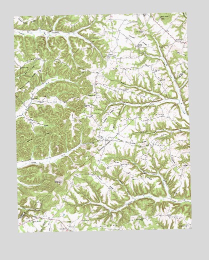
Mintonville, KY USGS Topographic Map
Click on map above to begin viewing in our Map Viewer.

This topographic map contains these locations and features:
Feature Name Type Latitude Longitude GNIS ID View Map
ArgylePopulated PlaceN37.2259°W84.8074°507410View Map
Argyle Post Office (historical)Post OfficeN37.2266°W84.8068°2568320View Map
Bethel KnobSummitN37.2265°W84.7566°486998View Map
BethelridgePopulated PlaceN37.2337°W84.7583°507499View Map
Bethelridge CemeteryCemeteryN37.2305°W84.7529°2568327View Map
Bethelridge School (historical)SchoolN37.2336°W84.7594°2568328View Map
Bradley Pleasure ChurchChurchN37.1320°W84.8641°487802View Map
Bradley SchoolSchoolN37.1337°W84.8611°487804View Map
Bright Post Office (historical)Post OfficeN37.2295°W84.7708°2568335View Map
Cains StoreLocaleN37.1265°W84.8394°488584View Map
Caintown CemeteryCemeteryN37.1306°W84.8361°488585View Map
Carter KnobSummitN37.1304°W84.8269°489011View Map
Carter RidgeRidgeN37.1590°W84.7916°489013View Map
Carter Ridge ChurchChurchN37.1620°W84.8008°489014View Map
Chapel RidgeRidgeN37.2348°W84.7858°489342View Map
Chestnut Level RidgeRidgeN37.2220°W84.8388°489453View Map
Chestnut Level SchoolSchoolN37.2209°W84.8705°489454View Map
Chuck Post Office (historical)Post OfficeN37.2026°W84.8637°2568351View Map
Chuckuluck SchoolSchoolN37.2026°W84.8636°489505View Map
Dye KnobSummitN37.1665°W84.8244°491383View Map
Fairview SchoolSchoolN37.1984°W84.8247°491932View Map
Ferndale (historical)Populated PlaceN37.2054°W84.7968°2568381View Map
Ferndale Church (historical)ChurchN37.2053°W84.7964°2568382View Map
Ferndale SchoolSchoolN37.2059°W84.7963°492047View Map
Fishing Creek ChurchChurchN37.1265°W84.7527°492129View Map
Grave Hill CemeteryCemeteryN37.1798°W84.8146°2568390View Map
Green River KnobSummitN37.1534°W84.8449°493294View Map
Henson CreekStreamN37.1992°W84.8638°494079View Map
Henson KnobSummitN37.1915°W84.8347°494080View Map
Hickory Nut RidgeRidgeN37.1320°W84.7813°494144View Map
Hughes RidgeRidgeN37.1920°W84.8086°494750View Map
Jonathan SchoolSchoolN37.2415°W84.8466°495447View Map
Joyce Post Office (historical)Post OfficeN37.2494°W84.7856°2568408View Map
Kellum BranchStreamN37.1934°W84.8697°495616View Map
Little Pointer CreekStreamN37.1415°W84.7644°496829View Map
MangumPopulated PlaceN37.1734°W84.7727°508530View Map
Mill CreekStreamN37.1981°W84.7949°498238View Map
MintonvillePopulated PlaceN37.1773°W84.8108°508616View Map
Mintonville CemeteryCemeteryN37.1774°W84.8097°2568432View Map
Mintonville Post Office (historical)Post OfficeN37.1775°W84.8122°2568433View Map
Mintonville School (historical)SchoolN37.1798°W84.8146°2568434View Map
Mount Lebanon ChurchChurchN37.1317°W84.7858°498764View Map
Oak Hill CemeteryCemeteryN37.2158°W84.7740°2568442View Map
Oak Hill RidgeRidgeN37.2167°W84.7847°499708View Map
Oak Hill SchoolSchoolN37.2167°W84.7741°499710View Map
Pawpaw CreekStreamN37.1990°W84.7663°500283View Map
Phelps CemeteryCemeteryN37.1971°W84.8298°2568447View Map
Pittman BranchStreamN37.1426°W84.7902°500782View Map
PointerPopulated PlaceN37.1329°W84.7672°508842View Map
Roberts CemeteryCemeteryN37.2048°W84.8629°2568470View Map
Rocky KnobSummitN37.2495°W84.7661°502254View Map
Rye Field RidgeRidgeN37.2042°W84.7933°502540View Map
Shady Grove RidgeRidgeN37.1759°W84.7941°503219View Map
Shady Grove SchoolSchoolN37.1740°W84.7763°503222View Map
Spaw CemeteryCemeteryN37.2095°W84.8191°504035View Map
Spaw KnobSummitN37.2042°W84.8205°504037View Map
Tarter KnobSummitN37.1829°W84.8197°504970View Map
Tick RidgeRidgeN37.1284°W84.8527°505271View Map
Valley Oak School (historical)SchoolN37.2289°W84.8053°2568492View Map
Valley Oaks CemeteryCemeteryN37.2259°W84.8038°2568493View Map
Valley Oaks United Baptist Church (historical)ChurchN37.2257°W84.8036°2568494View Map
Vaught RidgeRidgeN37.1912°W84.7824°506007View Map
Vaught SchoolSchoolN37.1879°W84.7799°506009View Map
WarePopulated PlaceN37.2087°W84.7688°509318View Map
Ware Post Office (historical)Post OfficeN37.2076°W84.7689°2568499View Map
Watson Chapel CemeteryCemeteryN37.2314°W84.7863°2568500View Map
Watson Chapel Christian ChurchChurchN37.2313°W84.7861°506282View Map
Watson KnobSummitN37.2401°W84.7849°506285View Map
Wells RidgeRidgeN37.1798°W84.8574°506383View Map
Wilson RidgeRidgeN37.1517°W84.8111°506913View Map
WKSO-TV (Somerset)TowerN37.1667°W84.8244°518069View Map
Wolf CreekStreamN37.1992°W84.7566°506993View Map
Woods SchoolSchoolN37.2495°W84.7816°507122View Map

Note: Coordinates in the location and feature list above are referenced to NAD83 datum.


Copyright (C) 2008-2025 Ryan Niemi / Sunset Dynamics ... All Rights Reserved