TopoQuest Logo
Do you find TopoQuest useful?
Help keep TopoQuest running and adding new maps/features by donating!
Bitcoin:  19c7KJd3qBynnjoSw5npx9KScwjBe4ifkT
Litecoin:  LXs6TkuXGGXo1vDsWCkWVdjQX94eUKd6ui
Home View Maps Find Maps Find Places Resources & Links


Delmer, Kentucky Topographic Map

USGS Map Title: Delmer, KY
USGS Map MRC: 37084A6
DRG (GeoTIFF) Download: o37084a6.tif


Neighboring USGS Topographic Map Quads:


  Mintonville, KY  
37084B7
 

  Science Hill, KY  
37084B6
 

  Bobtown, KY  
37084B5
 

  Faubush, KY  
37084A7
 

  Delmer, KY  
37084A6
 

  Somerset, KY  
37084A5
 

  Mill Springs, KY  
36084H7
 

  Frazer, KY  
36084H6
 

  Burnside, KY  
36084H5


Map MRC Location:

N38°
W85°
N38°
W84°
H8 H7 H6 H5 H4 H3 H2 H1
G8 G7 G6 G5 G4 G3 G2 G1
F8 F7 F6 F5 F4 F3 F2 F1
E8 E7 E6 E5 E4 E3 E2 E1
D8 D7 D6 D5 D4 D3 D2 D1
C8 C7 C6 C5 C4 C3 C2 C1
B8 B7 B6 B5 B4 B3 B2 B1
A8 A7 A6 A5 A4 A3 A2 A1
N37°
W85°
N37°
W84°

Delmer, KY USGS 1:24K Topographic Map Preview:
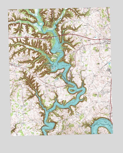
Delmer, KY USGS Topographic Map
Click on map above to begin viewing in our Map Viewer.

This topographic map contains these locations and features:
Feature Name Type Latitude Longitude GNIS ID View Map
Big Clifty CreekStreamN37.1037°W84.6963°487156View Map
Big Knob Lick (historical)AreaN37.0239°W84.7055°2725850View Map
Bogle CemeteryCemeteryN37.0769°W84.6296°2725585View Map
Bogle KnobSummitN37.0698°W84.6422°487623View Map
Brandley BranchStreamN37.0245°W84.6708°487824View Map
Clifty CreekStreamN37.0240°W84.7069°489680View Map
Coaker HollowValleyN37.1102°W84.6920°489717View Map
Coldweather CreekStreamN37.1079°W84.7108°489806View Map
Confederate Defense Line Historical MarkerParkN37.0688°W84.7358°2744706View Map
Crackers Neck (historical)Populated PlaceN37.0497°W84.7065°2725852View Map
Crockett (historical)Populated PlaceN37.0689°W84.6317°2725853View Map
DelmerPopulated PlaceN37.0290°W84.7347°507840View Map
Delmer ChurchChurchN37.0054°W84.7399°490800View Map
Denham KnobSummitN37.0934°W84.6536°490810View Map
Dry BranchStreamN37.0334°W84.6936°491140View Map
Fairview CemeteryCemeteryN37.0515°W84.7377°491899View Map
Felix K Zollicoffer Historical MarkerParkN37.0556°W84.7394°2744714View Map
Firebrook Volunteer Fire DepartmentBuildingN37.0194°W84.6661°2637351View Map
Fishing Creek BridgeBridgeN37.0517°W84.6794°492128View Map
Hale KnobSummitN37.0842°W84.6308°493557View Map
Hamby HollowValleyN37.0802°W84.7080°493611View Map
Hickory Nut RidgeRidgeN37.1209°W84.7330°494143View Map
HislopePopulated PlaceN37.0217°W84.7333°508253View Map
Hislope CemeteryCemeteryN37.0151°W84.7241°494309View Map
Lakeside Memorial GardensCemeteryN37.0578°W84.6777°495922View Map
Lee's AirparkAirportN37.0232°W84.7331°2444083View Map
Lees Ford (historical)CrossingN37.0316°W84.6738°2725687View Map
Lees Ford DockLocaleN37.0476°W84.6716°496183View Map
Long RidgeRidgeN37.0904°W84.7024°497137View Map
Mill Springs National CemeteryCemeteryN37.0690°W84.7376°498297View Map
Mount Olive ChurchChurchN37.0512°W84.6274°498791View Map
Mount Olive Church CemeteryCemeteryN37.0507°W84.6271°2725618View Map
NancyPopulated PlaceN37.0717°W84.7480°499160View Map
Nancy Fire DepartmentBuildingN37.0693°W84.7419°2637038View Map
Oak HillPopulated PlaceN37.0581°W84.6463°499700View Map
Oak Hill Baptist Church CemeteryCemeteryN37.0578°W84.6468°2725625View Map
Oakwood Training CenterBuildingN37.0634°W84.6272°499761View Map
Oil CenterPopulated PlaceN37.1059°W84.7069°508735View Map
Okalona ChurchChurchN37.0301°W84.7341°499793View Map
Patterson BranchStreamN37.0470°W84.6613°500253View Map
Piney Grove RidgeRidgeN37.1012°W84.7305°500735View Map
Pisgah CemeteryCemeteryN37.0273°W84.6308°500762View Map
Pleasant Hill ChurchChurchN37.1226°W84.6399°500860View Map
Pointer CreekStreamN37.1173°W84.7144°500996View Map
Porter CemeteryCemeteryN37.0123°W84.7380°501144View Map
Porter CreekStreamN37.0715°W84.6947°501147View Map
Potato KnollSummitN37.0442°W84.6749°501190View Map
RinggoldPopulated PlaceN37.1081°W84.6536°508940View Map
Saline ChurchChurchN37.0865°W84.6638°502803View Map
SardisPopulated PlaceN37.0456°W84.6961°509017View Map
ShafterPopulated PlaceN37.0140°W84.6916°509039View Map
ShepolaPopulated PlaceN37.0487°W84.7061°509047View Map
Silvers CemeteryCemeteryN37.0733°W84.6371°2725636View Map
Slate Branch ChurchChurchN37.0081°W84.6661°503637View Map
Smith KnobSummitN37.0831°W84.6416°503798View Map
Somerset Fire DepartmentBuildingN37.0850°W84.6261°2637320View Map
Somerset-Pulaski County EMS HeliportAirportN37.0854°W84.6255°517490View Map
Sulphur Springs HollowValleyN37.0919°W84.6836°504773View Map
Timmy BranchStreamN37.0412°W84.7180°505287View Map
Todd HollowValleyN37.0604°W84.6853°505315View Map
TrimblePopulated PlaceN37.0120°W84.7358°509236View Map
Turpin BranchStreamN37.0715°W84.6997°505680View Map
Veech Haven ChurchChurchN37.0770°W84.6974°506014View Map
Waddle BranchStreamN37.0884°W84.7277°506082View Map
Wait KnobSummitN37.0392°W84.6461°506106View Map
Waite (historical)Populated PlaceN37.0319°W84.6358°2725932View Map
WLLK-FM (Somerset)TowerN37.0781°W84.6774°517741View Map
WTLO-AM (Somerset)TowerN37.0876°W84.6372°517665View Map
Zollicoffer Park CemeteryCemeteryN37.0556°W84.7390°507305View Map

Note: Coordinates in the location and feature list above are referenced to NAD83 datum.


Copyright (C) 2008-2024 Ryan Niemi / Sunset Dynamics ... All Rights Reserved