TopoQuest Logo
Do you find TopoQuest useful?
Help keep TopoQuest running and adding new maps/features by donating!
Bitcoin:  19c7KJd3qBynnjoSw5npx9KScwjBe4ifkT
Litecoin:  LXs6TkuXGGXo1vDsWCkWVdjQX94eUKd6ui
Home View Maps Find Maps Find Places Resources & Links


Monroe Peak, Utah Topographic Map

USGS Map Title: Monroe Peak, UT
USGS Map MRC: 38112E1
DRG (GeoTIFF) Download: o38112e1.tif


Neighboring USGS Topographic Map Quads:


  Elsinore, UT  
38112F2
 

  Annabella, UT  
38112F1
 

  Water Creek Canyon, UT  
38111F8
 

  Antelope Range, UT  
38112E2
 

  Monroe Peak, UT  
38112E1
 

  Koosharem, UT  
38111E8
 

  Marysvale, UT  
38112D2
 

  Marysvale Peak, UT  
38112D1
 

  Greenwich, UT  
38111D8


Map MRC Location:

N39°
W113°
N39°
W112°
H8 H7 H6 H5 H4 H3 H2 H1
G8 G7 G6 G5 G4 G3 G2 G1
F8 F7 F6 F5 F4 F3 F2 F1
E8 E7 E6 E5 E4 E3 E2 E1
D8 D7 D6 D5 D4 D3 D2 D1
C8 C7 C6 C5 C4 C3 C2 C1
B8 B7 B6 B5 B4 B3 B2 B1
A8 A7 A6 A5 A4 A3 A2 A1
N38°
W113°
N38°
W112°

Monroe Peak, UT USGS 1:24K Topographic Map Preview:
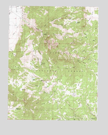
Monroe Peak, UT USGS Topographic Map
Click on map above to begin viewing in our Map Viewer.

This topographic map contains these locations and features:
Feature Name Type Latitude Longitude GNIS ID View Map
Bagley MeadowsFlatN38.5591°W112.0013°1438326View Map
Bertlesen CanyonValleyN38.6166°W112.1066°1438615View Map
Bertlesen DitchCanalN38.5897°W112.1216°1438616View Map
Brindley FlatFlatN38.5164°W112.0249°1439120View Map
City of MonroeCivilN38.6229°W112.1199°2411136View Map
Corner Spring CanyonValleyN38.5711°W112.0966°1448302View Map
Devils Dutch OvenSummitN38.5430°W112.0796°1448344View Map
Doxford CreekStreamN38.5694°W112.0363°1440542View Map
Eagle FlatFlatN38.5433°W112.0105°1440759View Map
First Lefthand ForkStreamN38.5980°W112.0824°1441056View Map
Fitzgeral ParkFlatN38.5378°W112.0830°1448404View Map
Glenwood MountainSummitN38.6250°W112.0152°1454596View Map
Hot SpringsSpringN38.6139°W112.1091°1448493View Map
Hunts LakesLakeN38.5455°W112.0894°1441955View Map
Jackass CreekStreamN38.5691°W112.0305°1442082View Map
Jackass FlatFlatN38.5908°W112.0183°1448515View Map
Koosharem Guard Station Scrub Flat TrailTrailN38.5833°W112.0158°1454985View Map
Lower Hunts LakeLakeN38.5333°W112.1065°1448628View Map
Monkey Flat RidgeRidgeN38.5219°W112.0610°1443554View Map
Monkey Fork Dry CanyonStreamN38.5194°W112.0999°1448677View Map
Monroe CreekStreamN38.6086°W112.1202°1443558View Map
Monroe MeadowsFlatN38.5278°W112.0338°1443559View Map
Monroe PeakSummitN38.5361°W112.0733°1443561View Map
Monrovian ParkFlatN38.5944°W112.0760°1443562View Map
Monrovian Park CampgroundLocaleN38.5941°W112.0763°1448681View Map
Mud LakeLakeN38.5946°W112.0163°1448709View Map
Mud SpringSpringN38.5605°W112.0791°1443688View Map
Mud Spring FlatFlatN38.5608°W112.0769°1448714View Map
Nielsen CanyonValleyN38.5619°W112.0296°1443824View Map
Oak FlatFlatN38.5758°W112.0902°1448764View Map
Oak Flat CreekStreamN38.5966°W112.0805°1448765View Map
Oscars VisionSummitN38.5655°W112.0291°1448788View Map
Reservoir CreekStreamN38.5747°W112.0080°1444870View Map
Sage FlatFlatN38.5372°W112.0285°1445236View Map
Sawmill FlatFlatN38.5272°W112.0621°1445350View Map
Sawmill SpringSpringN38.5883°W112.0079°1448977View Map
Scrub FlatFlatN38.6230°W112.0319°1448982View Map
Scrub Flat ReservoirReservoirN38.6074°W112.0309°1445398View Map
Second Lefthand ForkStreamN38.5944°W112.0763°1445407View Map
Second Lefthand Fork TrailTrailN38.5900°W112.0452°1449948View Map
Serviceberry CreekStreamN38.5964°W112.0796°1445432View Map
Serviceberry TrailTrailN38.5736°W112.0849°1445435View Map
Sevier County Ambulance - MonoreBuildingN38.6207°W112.1210°2768486View Map
Shingle CreekStreamN38.6055°W112.0621°1445529View Map
South Bend CanalCanalN38.6194°W112.1208°1445791View Map
South Fork Monroe CreekStreamN38.5947°W112.0763°1445858View Map
The GatesGapN38.6103°W112.1060°1446451View Map
The GatesLocaleN38.6086°W112.1027°1451250View Map
The SinksBasinN38.5700°W112.0277°1446503View Map
Third Lefthand ForkStreamN38.5789°W112.0558°1446526View Map
Third Lefthand Fork TrailTrailN38.5786°W112.0430°1449943View Map
Washburn ReservoirReservoirN38.6239°W112.0319°1449160View Map

Note: Coordinates in the location and feature list above are referenced to NAD83 datum.


Copyright (C) 2008-2024 Ryan Niemi / Sunset Dynamics ... All Rights Reserved