TopoQuest Logo
Do you find TopoQuest useful?
Help keep TopoQuest running and adding new maps/features by donating!
Bitcoin:  19c7KJd3qBynnjoSw5npx9KScwjBe4ifkT
Litecoin:  LXs6TkuXGGXo1vDsWCkWVdjQX94eUKd6ui
Home View Maps Find Maps Find Places Resources & Links


Water Creek Canyon, Utah Topographic Map

USGS Map Title: Water Creek Canyon, UT
USGS Map MRC: 38111F8
DRG (GeoTIFF) Download: o38111f8.tif


Neighboring USGS Topographic Map Quads:


  Richfield, UT  
38112G1
 

  Sigurd, UT  
38111G8
 

  Rex Reservoir, UT  
38111G7
 

  Annabella, UT  
38112F1
 

  Water Creek Canyon, UT  
38111F8
 

  Boobe Hole Reservoir, UT  
38111F7
 

  Monroe Peak, UT  
38112E1
 

  Koosharem, UT  
38111E8
 

  Burrville, UT  
38111E7


Map MRC Location:

N39°
W112°
N39°
W111°
H8 H7 H6 H5 H4 H3 H2 H1
G8 G7 G6 G5 G4 G3 G2 G1
F8 F7 F6 F5 F4 F3 F2 F1
E8 E7 E6 E5 E4 E3 E2 E1
D8 D7 D6 D5 D4 D3 D2 D1
C8 C7 C6 C5 C4 C3 C2 C1
B8 B7 B6 B5 B4 B3 B2 B1
A8 A7 A6 A5 A4 A3 A2 A1
N38°
W112°
N38°
W111°

Water Creek Canyon, UT USGS 1:24K Topographic Map Preview:
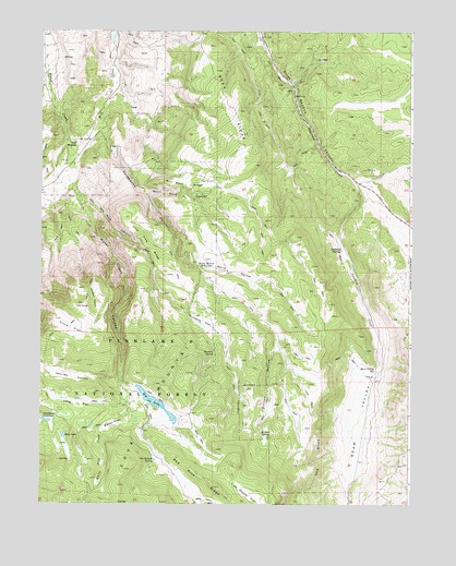
Water Creek Canyon, UT USGS Topographic Map
Click on map above to begin viewing in our Map Viewer.

This topographic map contains these locations and features:
Feature Name Type Latitude Longitude GNIS ID View Map
Bear ValleyValleyN38.6614°W111.8855°1438499View Map
Bear Valley ReservoirReservoirN38.6603°W111.8869°1438502View Map
Bell Rock CanyonValleyN38.7086°W111.9669°1438579View Map
Bell Rock RidgeRidgeN38.7100°W111.9494°1438580View Map
Big LakeReservoirN38.6512°W111.9604°1438699View Map
Big Lake Reservoir DamDamN38.6550°W111.9674°1447731View Map
Brimhall SpringsSpringN38.6921°W111.8984°1439118View Map
Chicken GulchValleyN38.6830°W111.9844°1439673View Map
Christensen SpringSpringN38.6363°W111.9615°1439727View Map
Circle FlatFlatN38.6716°W111.9894°1439745View Map
Davis HollowValleyN38.6969°W111.9533°1440286View Map
Davis Hollow ReservoirReservoirN38.6876°W111.9442°1440288View Map
Deep LakeReservoirN38.6432°W111.9923°1440359View Map
Deep Lake DamDamN38.6433°W111.9924°1447729View Map
East Hunter FlatFlatN38.6264°W111.9291°1440832View Map
Henries HollowValleyN38.6575°W111.9741°1441709View Map
Hunters FlatFlatN38.6725°W111.9441°1441950View Map
Hunters SpringSpringN38.6650°W111.9417°1441951View Map
Killian HollowValleyN38.6841°W111.9438°1442314View Map
Killian SpringSpringN38.6439°W111.9252°1442315View Map
Lone Pine RidgeRidgeN38.6927°W111.9624°1442878View Map
Long FlatFlatN38.6511°W111.9874°1442906View Map
Red Pine RidgeRidgeN38.6297°W111.9410°1444828View Map
Rock CanyonValleyN38.7033°W111.9813°1445032View Map
Sand Ledges Recreation AreaParkN38.7130°W111.8835°1436304View Map
Saul MeadowFlatN38.7200°W111.9877°1445342View Map
Squeedunk CanyonValleyN38.7241°W111.9799°1446087View Map
The BrinkCliffN38.6375°W111.9052°1446420View Map
The CircleFlatN38.6766°W111.9863°1446427View Map
Water CreekStreamN38.7491°W111.9977°1447044View Map
Water Creek CanyonValleyN38.7014°W111.9844°1447045View Map
Water FlatFlatN38.6458°W111.9766°1447046View Map
White Pine CreekStreamN38.6572°W111.9710°1447268View Map

Note: Coordinates in the location and feature list above are referenced to NAD83 datum.


Copyright (C) 2008-2024 Ryan Niemi / Sunset Dynamics ... All Rights Reserved