TopoQuest Logo
Do you find TopoQuest useful?
Help keep TopoQuest running and adding new maps/features by donating!
Bitcoin:  19c7KJd3qBynnjoSw5npx9KScwjBe4ifkT
Litecoin:  LXs6TkuXGGXo1vDsWCkWVdjQX94eUKd6ui
Home View Maps Find Maps Find Places Resources & Links


Montaqua, Montana Topographic Map

USGS Map Title: Montaqua, MT
USGS Map MRC: 45108E8
DRG (GeoTIFF) Download: o45108e8.tif


Neighboring USGS Topographic Map Quads:


  Horse Butte, MT  
45109F1
 

  Park City, MT  
45108F8
 

  Laurel, MT  
45108F7
 

  Rapids, MT  
45109E1
 

  Montaqua, MT  
45108E8
 

  Silesia, MT  
45108E7
 

  Boyd, MT  
45109D1
 

  Fromberg, MT  
45108D8
 

  Edgar, MT  
45108D7


Map MRC Location:

N46°
W109°
N46°
W108°
H8 H7 H6 H5 H4 H3 H2 H1
G8 G7 G6 G5 G4 G3 G2 G1
F8 F7 F6 F5 F4 F3 F2 F1
E8 E7 E6 E5 E4 E3 E2 E1
D8 D7 D6 D5 D4 D3 D2 D1
C8 C7 C6 C5 C4 C3 C2 C1
B8 B7 B6 B5 B4 B3 B2 B1
A8 A7 A6 A5 A4 A3 A2 A1
N45°
W109°
N45°
W108°

Montaqua, MT USGS 1:24K Topographic Map Preview:
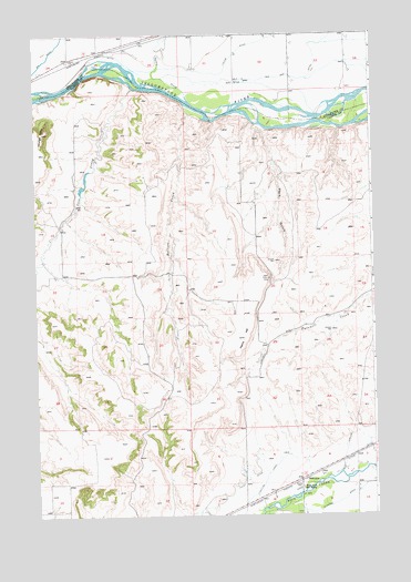
Montaqua, MT USGS Topographic Map
Click on map above to begin viewing in our Map Viewer.

This topographic map contains these locations and features:
Feature Name Type Latitude Longitude GNIS ID View Map
02S22E25DBBD01 SpringSpringN45.6249°W108.9535°810634View Map
02S22E34ADCB01 WellWellN45.6188°W108.9915°810595View Map
02S22E36BCAA01 WellWellN45.6199°W108.9618°810601View Map
02S23E31CBAA01 WellWellN45.6169°W108.9407°810577View Map
02S23E32BAAA01 WellWellN45.6238°W108.9157°810621View Map
02S23E32CCBB01 WellWellN45.6133°W108.9251°810543View Map
02S23E33BBCA01 WellWellN45.6222°W108.9035°810614View Map
02S23E33CCBC01 WellWellN45.6124°W108.9035°810537View Map
02S23E34CBCA01 WellWellN45.6149°W108.8821°810553View Map
03S22E02CADB01 WellWellN45.6005°W108.9771°810414View Map
03S23E31BABA01 WellWellN45.5363°W108.9374°810024View Map
04S23E03BCDA01 WellWellN45.5172°W108.8779°809918View Map
04S23E08AA__01 WellWellN45.5063°W108.9054°809846View Map
04S23E09BCBC01 WellWellN45.5033°W108.9024°809828View Map
Bellion CreekStreamN45.6049°W108.9435°768687View Map
Clawson DitchCanalN45.5061°W108.8826°769910View Map
Cole CreekStreamN45.6111°W108.9632°770022View Map
Cole Creek School (historical)SchoolN45.5624°W108.9924°1726820View Map
Dutton CanalCanalN45.5052°W108.9199°770939View Map
Four Buttes School (historical)SchoolN45.5097°W108.9224°1726828View Map
Golden Glenn Number 1 DamDamN45.5899°W108.9807°797286View Map
Harris HillSummitN45.5461°W108.9235°772171View Map
Homestead Island Fishing Access SiteLocaleN45.6088°W108.8865°1744504View Map
Joliet DivisionCivilN45.5107°W108.9996°1940648View Map
Mont Aqua Hot SpringLocaleN45.5072°W108.9026°774339View Map
MontaquaPopulated PlaceN45.5091°W108.9013°774349View Map
Peck GulchValleyN45.6008°W108.9176°775134View Map
Valley CreekStreamN45.6080°W108.9426°777974View Map
Youngs PointSummitN45.5997°W108.9968°778752View Map

Note: Coordinates in the location and feature list above are referenced to NAD83 datum.


Copyright (C) 2008-2024 Ryan Niemi / Sunset Dynamics ... All Rights Reserved