TopoQuest Logo
Do you find TopoQuest useful?
Help keep TopoQuest running and adding new maps/features by donating!
Bitcoin:  19c7KJd3qBynnjoSw5npx9KScwjBe4ifkT
Litecoin:  LXs6TkuXGGXo1vDsWCkWVdjQX94eUKd6ui
Home View Maps Find Maps Find Places Resources & Links


Park City, Montana Topographic Map

USGS Map Title: Park City, MT
USGS Map MRC: 45108F8
DRG (GeoTIFF) Download: o45108f8.tif


Neighboring USGS Topographic Map Quads:


  Hunter Lake, MT  
45109G1
 

  Molt, MT  
45108G8
 

  Two Pine School, MT  
45108G7
 

  Horse Butte, MT  
45109F1
 

  Park City, MT  
45108F8
 

  Laurel, MT  
45108F7
 

  Rapids, MT  
45109E1
 

  Montaqua, MT  
45108E8
 

  Silesia, MT  
45108E7


Map MRC Location:

N46°
W109°
N46°
W108°
H8 H7 H6 H5 H4 H3 H2 H1
G8 G7 G6 G5 G4 G3 G2 G1
F8 F7 F6 F5 F4 F3 F2 F1
E8 E7 E6 E5 E4 E3 E2 E1
D8 D7 D6 D5 D4 D3 D2 D1
C8 C7 C6 C5 C4 C3 C2 C1
B8 B7 B6 B5 B4 B3 B2 B1
A8 A7 A6 A5 A4 A3 A2 A1
N45°
W109°
N45°
W108°

Park City, MT USGS 1:24K Topographic Map Preview:
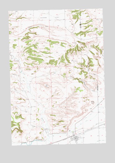
Park City, MT USGS Topographic Map
Click on map above to begin viewing in our Map Viewer.

This topographic map contains these locations and features:
Feature Name Type Latitude Longitude GNIS ID View Map
01S22E14CBBB01 WellWellN45.7474°W108.9868°811632View Map
02S23E09BBAC01 WellWellN45.6813°W108.9018°811091View Map
02S23E10CDDB01 WellWellN45.6688°W108.8751°810976View Map
02S23E15CDBB01 WellWellN45.6574°W108.8776°810870View Map
02S23E16DADD01 WellWellN45.6563°W108.8849°810866View Map
02S23E20ADDC01 WellWellN45.6472°W108.9065°810785View Map
02S23E21CCCC01 WellWellN45.6397°W108.9043°810736View Map
02S23E27BABB01 WellWellN45.6386°W108.8788°810731View Map
02S23E28CBBC01 WellWellN45.6313°W108.9049°810686View Map
02S23E29BDAC01 WellWellN45.6336°W108.9185°810709View Map
02S23E29BDAD01 WellWellN45.6344°W108.9163°810711View Map
02S23E30CCCC01 WellWellN45.6252°W108.9451°810638View Map
Benedict GulchValleyN45.6730°W108.8865°768699View Map
Cottonwood CreekStreamN45.6797°W108.9765°770167View Map
Dry CreekStreamN45.6622°W108.9624°770784View Map
Indian GulchValleyN45.7033°W108.8757°772693View Map
Interchange 426CrossingN45.6344°W108.9160°1726926View Map
Italian DitchCanalN45.6388°W108.8932°772742View Map
Miller ButteSummitN45.6780°W108.9510°774233View Map
Old Mill DitchCanalN45.6274°W108.8815°774935View Map
Park CityPopulated PlaceN45.6327°W108.9179°775081View Map
Park CityLocaleN45.6322°W108.9201°1726977View Map
Park City AmbulanceBuildingN45.6315°W108.9172°2637885View Map
Park City Baptist ChurchChurchN45.6308°W108.9207°1726889View Map
Park City Catholic Church (historical)ChurchN45.6327°W108.9179°1726887View Map
Park City Census Designated PlaceCensusN45.6292°W108.9215°2409026View Map
Park City Methodist Church (historical)ChurchN45.6327°W108.9179°1726888View Map
Park City Post OfficePost OfficeN45.6312°W108.9163°1726979View Map
Park City Rural Fire District - Park City Volunteer Fire DepartmentBuildingN45.6315°W108.9171°2546745View Map
Park City SchoolSchoolN45.6298°W108.9156°1726951View Map
Pioneer CemeteryCemeteryN45.6574°W108.8951°775256View Map
Saint Paul Lutheran ChurchChurchN45.6288°W108.9168°1726890View Map
Sawmill GulchValleyN45.7313°W108.9754°776249View Map
Square ButteSummitN45.6630°W108.8910°777102View Map
Swamp CreekStreamN45.6747°W108.9749°777351View Map

Note: Coordinates in the location and feature list above are referenced to NAD83 datum.


Copyright (C) 2008-2024 Ryan Niemi / Sunset Dynamics ... All Rights Reserved