TopoQuest Logo
Do you find TopoQuest useful?
Help keep TopoQuest running and adding new maps/features by donating!
Bitcoin:  19c7KJd3qBynnjoSw5npx9KScwjBe4ifkT
Litecoin:  LXs6TkuXGGXo1vDsWCkWVdjQX94eUKd6ui
Home View Maps Find Maps Find Places Resources & Links


Montgomery Island, Arkansas Topographic Map

USGS Map Title: Montgomery Island, AR
USGS Map MRC: 33091H1
DRG (GeoTIFF) Download: o33091h1.tif


Neighboring USGS Topographic Map Quads:


  Henrico SW, AR  
34091A2
 

  Snow Lake, AR  
34091A1
 

  Laconia, AR  
34090A8
 

  Yancopin, AR  
33091H2
 

  Montgomery Island, AR  
33091H1
 

  Gunnison, MS  
33090H8
 

  Lake Cheatham, AR  
33091G2
 

  Rosedale, MS  
33091G1
 

  Beulah, MS  
33090G8


Map MRC Location:

N34°
W92°
N34°
W91°
H8 H7 H6 H5 H4 H3 H2 H1
G8 G7 G6 G5 G4 G3 G2 G1
F8 F7 F6 F5 F4 F3 F2 F1
E8 E7 E6 E5 E4 E3 E2 E1
D8 D7 D6 D5 D4 D3 D2 D1
C8 C7 C6 C5 C4 C3 C2 C1
B8 B7 B6 B5 B4 B3 B2 B1
A8 A7 A6 A5 A4 A3 A2 A1
N33°
W92°
N33°
W91°

Montgomery Island, AR USGS 1:24K Topographic Map Preview:
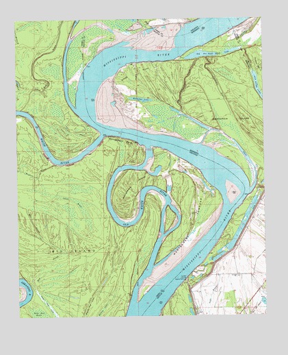
Montgomery Island, AR USGS Topographic Map
Click on map above to begin viewing in our Map Viewer.

This topographic map contains these locations and features:
Feature Name Type Latitude Longitude GNIS ID View Map
Big IslandFlatN33.9043°W91.1001°46576View Map
Big Island RevetmentLeveeN33.9501°W91.0709°70281View Map
Birmingham BendBendN33.9401°W91.1015°63818View Map
Brush Top LakeSwampN33.8790°W91.0903°47051View Map
Concordia BayouStreamN33.9837°W91.0337°668752View Map
Concordia Bend (historical)BendN33.9926°W91.0448°63819View Map
Concordia ChuteGutN33.9462°W91.0132°668754View Map
Concordia DrainStreamN33.9843°W91.0296°668755View Map
Concordia IslandIslandN33.9557°W91.0065°668756View Map
Coono BrakeSwampN33.9257°W91.1039°48005View Map
Henrico DikesLeveeN33.9948°W91.0479°70288View Map
Jackson BendBendN33.9168°W91.0754°63822View Map
Lane Landing (historical)LocaleN33.8801°W91.0509°687992View Map
Little Red BarBarN33.9537°W91.0787°687993View Map
Mayhorn BayouStreamN33.9396°W91.1051°51762View Map
McClellan LakeLakeN33.9664°W91.0617°673303View Map
Montgomery BendBendN33.9521°W91.0723°63820View Map
Montgomery CutoffChannelN33.9409°W91.0596°63821View Map
Montgomery IslandIslandN33.9251°W91.0698°52139View Map
Montgomery PointCapeN33.9459°W91.0709°52141View Map
Montgomery TowheadIslandN33.9104°W91.0384°52143View Map
Montgomery Towhead DikesLeveeN33.8959°W91.0501°70289View Map
Mud SloughGutN33.8946°W91.1112°52522View Map
Old Tar Paper Shack LakeLakeN33.9861°W91.0308°675260View Map
Old White RiverStreamN33.8798°W91.0679°53037View Map
Rose LandingLocaleN33.9418°W91.1084°63817View Map
Rosedale CemeteryCemeteryN33.8773°W91.0351°676871View Map
Saint Pauls ChurchChurchN33.8921°W91.0151°677218View Map
Scrubgrass BendBendN33.9654°W91.0898°70291View Map
Scrubgrass Bend RevetmentLeveeN33.9723°W91.0937°70292View Map
Sixmile BayouGutN33.9865°W91.1107°54882View Map
Smith PointCapeN33.9779°W91.0668°677937View Map
Terrene LandingPopulated PlaceN33.8907°W91.0404°692261View Map
Victoria BendBendN33.9279°W91.0101°63823View Map
White RiverPopulated PlaceN33.8834°W91.0690°63825View Map
White RiverStreamN33.9515°W91.0815°78762View Map
White River LandingLocaleN33.8809°W91.0690°63824View Map
White River Landing DikesLeveeN33.8873°W91.0579°70293View Map
Willow LakeSwampN33.8775°W91.0832°56417View Map

Note: Coordinates in the location and feature list above are referenced to NAD83 datum.


Copyright (C) 2008-2025 Ryan Niemi / Sunset Dynamics ... All Rights Reserved