TopoQuest Logo
Do you find TopoQuest useful?
Help keep TopoQuest running and adding new maps/features by donating!
Bitcoin:  19c7KJd3qBynnjoSw5npx9KScwjBe4ifkT
Litecoin:  LXs6TkuXGGXo1vDsWCkWVdjQX94eUKd6ui
Home View Maps Find Maps Find Places Resources & Links


Snow Lake, Arkansas Topographic Map

USGS Map Title: Snow Lake, AR
USGS Map MRC: 34091A1
DRG (GeoTIFF) Download: o34091a1.tif


Neighboring USGS Topographic Map Quads:


  Weber, AR  
34091B2
 

  Henrico NE, AR  
34091B1
 

  Mellwood, AR  
34090B8
 

  Henrico SW, AR  
34091A2
 

  Snow Lake, AR  
34091A1
 

  Laconia, AR  
34090A8
 

  Yancopin, AR  
33091H2
 

  Montgomery Island, AR  
33091H1
 

  Gunnison, MS  
33090H8


Map MRC Location:

N35°
W92°
N35°
W91°
H8 H7 H6 H5 H4 H3 H2 H1
G8 G7 G6 G5 G4 G3 G2 G1
F8 F7 F6 F5 F4 F3 F2 F1
E8 E7 E6 E5 E4 E3 E2 E1
D8 D7 D6 D5 D4 D3 D2 D1
C8 C7 C6 C5 C4 C3 C2 C1
B8 B7 B6 B5 B4 B3 B2 B1
A8 A7 A6 A5 A4 A3 A2 A1
N34°
W92°
N34°
W91°

Snow Lake, AR USGS 1:24K Topographic Map Preview:
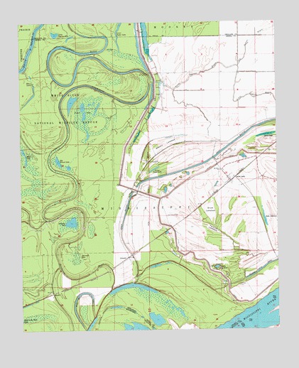
Snow Lake, AR USGS Topographic Map
Click on map above to begin viewing in our Map Viewer.

This topographic map contains these locations and features:
Feature Name Type Latitude Longitude GNIS ID View Map
Alligator LakeLakeN34.0439°W91.1005°75628View Map
Bear Lake (historical)LakeN34.0704°W91.0584°63785View Map
Big Round LakeLakeN34.0687°W91.1068°75645View Map
Brushy LakebedFlatN34.0754°W91.0548°47087View Map
Deep BayouStreamN34.0190°W91.0709°48441View Map
Elbow LakesLakeN34.0942°W91.1204°75703View Map
Graddy Blue HoleLakeN34.0255°W91.0299°75719View Map
Gum Grove CemeteryCemeteryN34.0468°W91.0543°49715View Map
Half Moon LakeLakeN34.0152°W91.0930°75730View Map
Henrico (historical)Populated PlaceN34.0140°W91.0112°63788View Map
Henrico BarBarN34.0084°W91.0348°70286View Map
Henrico CemeteryCemeteryN34.0182°W91.0190°70287View Map
Laconia Circle LeveeLeveeN34.0301°W91.0412°50930View Map
Lake DefianceLakeN34.0446°W91.0062°75693View Map
Little Cypress BayouStreamN34.1007°W91.0562°51251View Map
Little Cypress LakeLakeN34.1204°W91.1077°75762View Map
Lower Swan LakeLakeN34.0653°W91.0600°75780View Map
Lower Taylor LakeLakeN34.1245°W91.0754°75010View Map
Moon LakeLakeN34.0723°W91.1234°75791View Map
Mount Olive ChurchChurchN34.0654°W91.0279°52345View Map
MozartPopulated PlaceN34.0148°W91.1098°57133View Map
New Canaan ChurchChurchN34.0684°W91.0629°77810View Map
New Cane School (historical)SchoolN34.0687°W91.0629°63784View Map
Old Indian BayouGutN34.1179°W91.0112°53001View Map
Prairie LakesLakeN34.0872°W91.0938°75826View Map
Scrubgrass CampgroundLocaleN34.1043°W91.0623°54655View Map
Sixmile BayouStreamN34.0448°W91.1126°78372View Map
Snow LakePopulated PlaceN34.0609°W91.0232°78398View Map
Snow Lake (historical)LakeN34.0482°W91.0329°63786View Map
Snow Lake Baptist ChurchChurchN34.0615°W91.0243°63783View Map
Snow Lake Post OfficePost OfficeN34.0612°W91.0241°2781887View Map
Snow LakebedFlatN34.0487°W91.0332°54989View Map
StimsonPopulated PlaceN34.0295°W91.0732°57195View Map
Swan LakeLakeN34.0791°W91.0043°75862View Map
Tarblue Lake (historical)LakeN34.0409°W91.0315°63787View Map
Tarblue LakebedFlatN34.0409°W91.0318°55433View Map
Thompsons CemeteryCemeteryN34.0764°W91.0271°55550View Map
Township of MississippiCivilN34.0477°W91.0451°66502View Map
Yancopin LakeSwampN34.0296°W91.0990°56582View Map

Note: Coordinates in the location and feature list above are referenced to NAD83 datum.


Copyright (C) 2008-2025 Ryan Niemi / Sunset Dynamics ... All Rights Reserved