TopoQuest Logo
Do you find TopoQuest useful?
Help keep TopoQuest running and adding new maps/features by donating!
Bitcoin:  19c7KJd3qBynnjoSw5npx9KScwjBe4ifkT
Litecoin:  LXs6TkuXGGXo1vDsWCkWVdjQX94eUKd6ui
Home View Maps Find Maps Find Places Resources & Links


Beulah, Mississippi Topographic Map

USGS Map Title: Beulah, MS
USGS Map MRC: 33090G8
DRG (GeoTIFF) Download: o33090g8.tif


Neighboring USGS Topographic Map Quads:


  Montgomery Island, AR  
33091H1
 

  Gunnison, MS  
33090H8
 

  Shelby, MS  
33090H7
 

  Rosedale, MS  
33091G1
 

  Beulah, MS  
33090G8
 

  Pace, MS  
33090G7
 

  Benoit, MS  
33091F1
 

  Lobdell, MS  
33090F8
 

  Skene, MS  
33090F7


Map MRC Location:

N34°
W91°
N34°
W90°
H8 H7 H6 H5 H4 H3 H2 H1
G8 G7 G6 G5 G4 G3 G2 G1
F8 F7 F6 F5 F4 F3 F2 F1
E8 E7 E6 E5 E4 E3 E2 E1
D8 D7 D6 D5 D4 D3 D2 D1
C8 C7 C6 C5 C4 C3 C2 C1
B8 B7 B6 B5 B4 B3 B2 B1
A8 A7 A6 A5 A4 A3 A2 A1
N33°
W91°
N33°
W90°

Beulah, MS USGS 1:24K Topographic Map Preview:
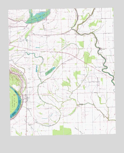
Beulah, MS USGS Topographic Map
Click on map above to begin viewing in our Map Viewer.

This topographic map contains these locations and features:
Feature Name Type Latitude Longitude GNIS ID View Map
Bethlehem ChurchChurchN33.8204°W90.9368°667017View Map
BeulahPopulated PlaceN33.7868°W90.9798°667037View Map
Beulah CemeteryCemeteryN33.7973°W90.9801°667039View Map
Beulah Fire DepartmentBuildingN33.7904°W90.9809°2666042View Map
Beulah Post OfficePost OfficeN33.7922°W90.9811°2768628View Map
Bob Malone Catfish Ponds DamDamN33.8118°W90.9651°682351View Map
Bold Pilgrim ChurchChurchN33.7979°W90.9759°667404View Map
Boles LakeLakeN33.8451°W90.9796°667406View Map
Bolivar CountyCivilN33.7955°W90.8804°695730View Map
Chenault FarmsLocaleN33.7686°W90.9328°2708726View Map
ChristmasPopulated PlaceN33.7765°W90.9784°691768View Map
CliffordPopulated PlaceN33.8237°W90.8851°711171View Map
Conservation Lake DamDamN33.8718°W90.9551°682380View Map
Conservation League LakeLakeN33.8687°W90.9600°668772View Map
Ditch Number NineCanalN33.8007°W90.9309°688048View Map
Ditch Number SevenCanalN33.7584°W90.9023°688052View Map
Ditch Number SevenCanalN33.7871°W90.9476°688056View Map
Ditch Number ThirteenCanalN33.7932°W90.9057°688065View Map
Ditch Number ThreeCanalN33.8482°W90.9968°688066View Map
Ditch Number TwelveCanalN33.8112°W90.9198°688071View Map
Ditch Number Twelve ACanalN33.8132°W90.9265°688072View Map
Ditch Number TwoCanalN33.8448°W90.9921°688078View Map
Dry BayouStreamN33.8021°W90.9615°669391View Map
GillPopulated PlaceN33.8057°W90.9765°670384View Map
Goffs BayouStreamN33.8596°W90.9773°670449View Map
Half Moon BayouStreamN33.7748°W90.9418°670832View Map
Henderson BayouStreamN33.7859°W90.9259°671099View Map
Lane BayouStreamN33.8521°W90.9190°672296View Map
Living Hope ChurchChurchN33.7768°W90.9548°672732View Map
MalvinaPopulated PlaceN33.8496°W90.9173°692039View Map
Martin CemeteryCemeteryN33.8134°W90.9362°673177View Map
Morning Star ChurchChurchN33.7609°W90.9779°673838View Map
Mound CityPopulated PlaceN33.7793°W90.9154°673901View Map
Mount Pleasant ChurchChurchN33.7632°W90.9679°674243View Map
New Hope CemeteryCemeteryN33.8343°W90.9804°674664View Map
New Hope ChurchChurchN33.8348°W90.8898°688008View Map
NilesPopulated PlaceN33.8554°W90.9573°692110View Map
Peters Rock ChurchChurchN33.7909°W90.8965°675653View Map
Pitts ChapelChurchN33.7787°W90.9195°688081View Map
Pleasant Grove ChurchChurchN33.7796°W90.9157°688083View Map
Rock of Ages ChurchChurchN33.8101°W90.9840°676742View Map
Saint Andrews ChurchChurchN33.8023°W90.9607°677008View Map
Saint Andrews ChurchChurchN33.8487°W90.9548°677009View Map
Scotland CemeteryCemeteryN33.8015°W90.9765°677462View Map
Scotland Plantation (historical)LocaleN33.8071°W90.9751°710144View Map
Sharewell CemeteryCemeteryN33.8307°W90.8934°677613View Map
Sugar Hill Plantation (historical)LocaleN33.7807°W90.9195°710149View Map
Supervisor District 1CivilN33.7661°W90.9689°695804View Map
SymondsPopulated PlaceN33.8340°W90.8904°678524View Map
Thousand Yard BayouStreamN33.7654°W90.8843°678732View Map
Town of BeulahCivilN33.7905°W90.9801°2405258View Map
Waldon CemeteryCemeteryN33.7782°W90.9523°679250View Map
Willow SloughGutN33.8054°W90.9826°679744View Map

Note: Coordinates in the location and feature list above are referenced to NAD83 datum.


Copyright (C) 2008-2025 Ryan Niemi / Sunset Dynamics ... All Rights Reserved