TopoQuest Logo
Do you find TopoQuest useful?
Help keep TopoQuest running and adding new maps/features by donating!
Bitcoin:  19c7KJd3qBynnjoSw5npx9KScwjBe4ifkT
Litecoin:  LXs6TkuXGGXo1vDsWCkWVdjQX94eUKd6ui
Home View Maps Find Maps Find Places Resources & Links


Monticello, Iowa Topographic Map

USGS Map Title: Monticello, IA
USGS Map MRC: 42091B2
DRG (GeoTIFF) Download: o42091b2.tif


Neighboring USGS Topographic Map Quads:


  Hopkinton West, IA  
42091C3
 

  Hopkinton East, IA  
42091C2
 

  Cascade, IA  
42091C1
 

  Anamosa NE, IA  
42091B3
 

  Monticello, IA  
42091B2
 

  Scotch Grove, IA  
42091B1
 

  Anamosa, IA  
42091A3
 

  Morley, IA  
42091A2
 

  Wyoming West, IA  
42091A1


Map MRC Location:

N43°
W92°
N43°
W91°
H8 H7 H6 H5 H4 H3 H2 H1
G8 G7 G6 G5 G4 G3 G2 G1
F8 F7 F6 F5 F4 F3 F2 F1
E8 E7 E6 E5 E4 E3 E2 E1
D8 D7 D6 D5 D4 D3 D2 D1
C8 C7 C6 C5 C4 C3 C2 C1
B8 B7 B6 B5 B4 B3 B2 B1
A8 A7 A6 A5 A4 A3 A2 A1
N42°
W92°
N42°
W91°

Monticello, IA USGS 1:24K Topographic Map Preview:
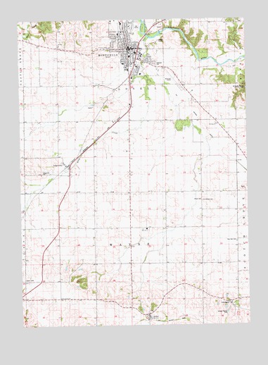
Monticello, IA USGS Topographic Map
Click on map above to begin viewing in our Map Viewer.

This topographic map contains these locations and features:
Feature Name Type Latitude Longitude GNIS ID View Map
AmberPopulated PlaceN42.1281°W91.1802°454164View Map
Amber (historical)LocaleN42.1281°W91.1802°2001797View Map
Amber CemeteryCemeteryN42.1306°W91.1788°454165View Map
Amber Post Office (historical)Post OfficeN42.1281°W91.1802°2001798View Map
Berean Bible ChurchChurchN42.1806°W91.1640°2001754View Map
Carpenter Elementary SchoolSchoolN42.2442°W91.1951°2001751View Map
Church of the NazareneChurchN42.2325°W91.1913°2001739View Map
City of MonticelloCivilN42.2304°W91.1836°2395386View Map
East MonticelloPopulated PlaceN42.2489°W91.1715°465534View Map
EdinburgPopulated PlaceN42.1333°W91.1340°464530View Map
Edinburg CemeteryCemeteryN42.1345°W91.1372°456239View Map
Edinburgh Ghost Town and MuseumLocaleN42.1347°W91.1363°2001814View Map
Edinburgh Post Office (historical)Post OfficeN42.1333°W91.1340°2001799View Map
First Church of the NazareneChurchN42.2383°W91.1871°2001742View Map
First Congregational ChurchChurchN42.2383°W91.1871°2001741View Map
First Presbyterian ChurchChurchN42.2378°W91.1913°2001738View Map
First United ChurchChurchN42.1364°W91.2288°456609View Map
Four Horn CemeteryCemeteryN42.1594°W91.1315°456701View Map
Jacobs ParkParkN42.2417°W91.1988°2001753View Map
John McDonald Hospital HeliportAirportN42.2389°W91.2007°466885View Map
Kiburz CemeteryCemeteryN42.1761°W91.1504°458067View Map
Kitty CreekStreamN42.2425°W91.1785°458118View Map
LangworthyPopulated PlaceN42.1911°W91.2240°458223View Map
Langworthy (historical)LocaleN42.1911°W91.2240°2001795View Map
Langworthy CemeteryCemeteryN42.1873°W91.2383°458224View Map
Langworthy Post Office (historical)Post OfficeN42.1911°W91.2240°2001796View Map
Mon-Maq DamDamN42.2447°W91.1721°2571119View Map
MonticelloPopulated PlaceN42.2383°W91.1871°459195View Map
Monticello (historical)LocaleN42.2417°W91.1918°2001733View Map
Monticello Ambulance ServiceBuildingN42.2320°W91.1876°2599777View Map
Monticello Baptist ChurchChurchN42.2344°W91.1882°2001735View Map
Monticello City ParkParkN42.2444°W91.1885°2001757View Map
Monticello Family Medical Associates CenterHospitalN42.2347°W91.1765°2001746View Map
Monticello Family Practice CenterHospitalN42.2319°W91.1793°2001745View Map
Monticello Golf ClubLocaleN42.2472°W91.1849°2001732View Map
Monticello Heritage CenterBuildingN42.2397°W91.1893°2001727View Map
Monticello High SchoolSchoolN42.2305°W91.1776°2001750View Map
Monticello Medical CenterHospitalN42.2319°W91.1863°2001744View Map
Monticello Middle SchoolSchoolN42.2366°W91.1859°2001749View Map
Monticello Nursing and Rehabilitation CenterHospitalN42.2278°W91.1832°2001743View Map
Monticello Police DepartmentBuildingN42.2326°W91.1878°2001728View Map
Monticello Post OfficePost OfficeN42.2386°W91.1901°2001730View Map
Monticello Public LibraryBuildingN42.2375°W91.1888°2001729View Map
Monticello Regional AirportAirportN42.2261°W91.1671°466884View Map
Monticello Volunteer Fire DepartmentBuildingN42.2320°W91.1876°2001724View Map
Oakwood CemeteryCemeteryN42.2322°W91.1763°459787View Map
Old Sutton School (historical)SchoolN42.1347°W91.1365°2001813View Map
Panther ParkParkN42.2306°W91.1932°2001752View Map
Peace United Church of ChristChurchN42.2400°W91.1849°2001737View Map
Riverside GardensParkN42.2417°W91.1835°2001756View Map
Sacred Heart ChurchChurchN42.2408°W91.1885°2001734View Map
Sacred Heart SchoolSchoolN42.2404°W91.1886°2001748View Map
Saint John's ChurchChurchN42.2081°W91.1413°461010View Map
Saint Johns ChurchChurchN42.2072°W91.1418°1825093View Map
Saint Johns Evangelical CemeteryCemeteryN42.2078°W91.1421°2001880View Map
Saint Joseph Catholic ChurchChurchN42.2383°W91.1871°2001740View Map
Saint Matthews Lutheran ChurchChurchN42.2403°W91.1896°2001736View Map
Shannon Elementary SchoolSchoolN42.2321°W91.1926°2001747View Map
Township of WayneCivilN42.1650°W91.1894°468957View Map
Wayne Zion CemeteryCemeteryN42.1638°W91.1809°462763View Map
Wayne Zion ChurchChurchN42.1650°W91.1827°462764View Map
West Kitty CreekStreamN42.2264°W91.1788°465395View Map
Y ParkParkN42.2281°W91.1890°2001755View Map
Zimmerman CemeteryCemeteryN42.1758°W91.1499°463258View Map
Zion ChurchChurchN42.1644°W91.1813°1825092View Map

Note: Coordinates in the location and feature list above are referenced to NAD83 datum.


Copyright (C) 2008-2025 Ryan Niemi / Sunset Dynamics ... All Rights Reserved