TopoQuest Logo
Do you find TopoQuest useful?
Help keep TopoQuest running and adding new maps/features by donating!
Bitcoin:  19c7KJd3qBynnjoSw5npx9KScwjBe4ifkT
Litecoin:  LXs6TkuXGGXo1vDsWCkWVdjQX94eUKd6ui
Home View Maps Find Maps Find Places Resources & Links


Monticello, Minnesota Topographic Map

USGS Map Title: Monticello, MN
USGS Map MRC: 45093C7
DRG (GeoTIFF) Download: o45093c7.tif


Neighboring USGS Topographic Map Quads:


  Clear Lake, MN  
45093D8
 

  Becker, MN  
45093D7
 

  Orrock, MN  
45093D6
 

  Silver Creek, MN  
45093C8
 

  Monticello, MN  
45093C7
 

  Big Lake, MN  
45093C6
 

  Buffalo West, MN  
45093B8
 

  Buffalo East, MN  
45093B7
 

  Saint Michael, MN  
45093B6


Map MRC Location:

N46°
W94°
N46°
W93°
H8 H7 H6 H5 H4 H3 H2 H1
G8 G7 G6 G5 G4 G3 G2 G1
F8 F7 F6 F5 F4 F3 F2 F1
E8 E7 E6 E5 E4 E3 E2 E1
D8 D7 D6 D5 D4 D3 D2 D1
C8 C7 C6 C5 C4 C3 C2 C1
B8 B7 B6 B5 B4 B3 B2 B1
A8 A7 A6 A5 A4 A3 A2 A1
N45°
W94°
N45°
W93°

Monticello, MN USGS 1:24K Topographic Map Preview:
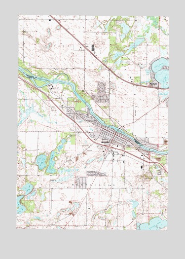
Monticello, MN USGS Topographic Map
Click on map above to begin viewing in our Map Viewer.

This topographic map contains these locations and features:
Feature Name Type Latitude Longitude GNIS ID View Map
A Glorious ChurchChurchN45.2950°W93.7619°2067240View Map
Bertram LakeReservoirN45.2866°W93.8503°1776722View Map
Bertram LakeLakeN45.2894°W93.8548°639982View Map
Bertram Lake DamDamN45.2866°W93.8503°1776721View Map
Beulah PondSwampN45.3366°W93.7691°640070View Map
Big LakeLakeN45.3387°W93.7542°640099View Map
Blacks LakeLakeN45.3430°W93.7673°640242View Map
Bridgeview Assembly of God ChurchChurchN45.3133°W93.7917°2069485View Map
Bucks LakeLakeN45.3681°W93.8020°640597View Map
Cardinal Hills ParkParkN45.2844°W93.7808°2067267View Map
Cedar LakeLakeN45.2632°W93.8737°641023View Map
Cedar Street MallLocaleN45.3014°W93.7944°2067250View Map
CentraCare Health - MonticelloHospitalN45.3005°W93.7785°2067253View Map
City of MonticelloCivilN45.2979°W93.7981°2395385View Map
Community United Methodist ChurchChurchN45.2847°W93.7689°2067241View Map
Country Club ParkParkN45.3056°W93.8133°2067276View Map
East Bridge ParkParkN45.3069°W93.7925°2067274View Map
Eastview Elementary SchoolSchoolN45.2866°W93.7721°2067258View Map
Ellison ParkParkN45.3033°W93.7806°2067271View Map
Faith Christian AcademySchoolN45.3133°W93.7917°2069484View Map
Faith Lutheran ChurchChurchN45.3333°W93.7653°2067245View Map
First Baptist ChurchChurchN45.3019°W93.7894°2067236View Map
First LakeLakeN45.3015°W93.8367°643650View Map
Flynn AirportAirportN45.3180°W93.7775°660301View Map
Fourth Street ParkParkN45.3017°W93.7883°2067273View Map
Helm CemeteryCemeteryN45.2813°W93.7711°644855View Map
Hidden LakeLakeN45.3676°W93.7866°644933View Map
Hillcrest ParkParkN45.3194°W93.8272°2067261View Map
Hillside CemeteryCemeteryN45.3009°W93.7967°645011View Map
Hope Evangelical Free ChurchChurchN45.3064°W93.8017°2067237View Map
Interchange 193CrossingN45.2986°W93.8000°2067519View Map
Interchange 195CrossingN45.2889°W93.7622°2067518View Map
Joyner Airport (historical)AirportN45.3164°W93.8169°660300View Map
Keller LakeLakeN45.3296°W93.7525°646068View Map
Kjellbergs Mobile Home ParkPopulated PlaceN45.2828°W93.8097°2067265View Map
KMOM-AM (Monticello)TowerN45.2750°W93.7925°663228View Map
Lake MitchellLakeN45.3467°W93.7577°648002View Map
Lake Mitchell ParkParkN45.3511°W93.7611°2069497View Map
Lake Ridge ParkParkN45.3536°W93.7708°2069498View Map
Lakeside ParkParkN45.3347°W93.7569°2069496View Map
Landis LakeLakeN45.3483°W93.7897°646467View Map
Little Mountain Elementary SchoolSchoolN45.2864°W93.7838°2067260View Map
Long LakeLakeN45.2881°W93.8467°647051View Map
McDowall LakeLakeN45.3542°W93.7553°2069495View Map
McDowall Lake ParkParkN45.3514°W93.7533°2069500View Map
Meadow Oak ParkParkN45.2764°W93.7556°2067272View Map
Mississippi River ParkParkN45.3000°W93.7761°2067270View Map
MonticelloPopulated PlaceN45.3055°W93.7941°648048View Map
Monticello - Big Lake Nursing HomeHospitalN45.2964°W93.7750°2067255View Map
Monticello (historical)LocaleN45.2986°W93.7819°2067251View Map
Monticello City HallBuildingN45.3025°W93.7986°2067247View Map
Monticello ClinicHospitalN45.2972°W93.7733°2067254View Map
Monticello Country ClubLocaleN45.3089°W93.8181°2067264View Map
Monticello Covenant ChurchChurchN45.2744°W93.8144°2067243View Map
Monticello Fire DepartmentBuildingN45.3030°W93.8002°2067246View Map
Monticello High SchoolSchoolN45.2867°W93.7780°2067259View Map
Monticello Middle SchoolSchoolN45.3005°W93.7825°2067257View Map
Monticello Post OfficePost OfficeN45.3075°W93.7978°2067249View Map
Monticello Public LibraryBuildingN45.3039°W93.7969°2067248View Map
Montissippi County ParkParkN45.3236°W93.8333°2067278View Map
Mud LakeLakeN45.2978°W93.8395°648238View Map
North LakeLakeN45.2735°W93.8662°648661View Map
Otter CreekStreamN45.3136°W93.8086°649046View Map
Otter Creek ParkParkN45.3139°W93.8178°2067277View Map
Pinewood Elementary SchoolSchoolN45.3098°W93.8093°2067256View Map
Pioneer ParkParkN45.2842°W93.7861°2067266View Map
Resurrection Lutheran ChurchChurchN45.2856°W93.7689°2067242View Map
River Terrace Mobile Home ParkPopulated PlaceN45.3222°W93.8222°2067269View Map
Riverplace Physicians CenterHospitalN45.3047°W93.7967°2067252View Map
Riverside Alliance ChurchChurchN45.3100°W93.7869°2069486View Map
Riverside CemeteryCemeteryN45.3155°W93.8133°650118View Map
Saint Henry Catholic ChurchChurchN45.2969°W93.7814°2067238View Map
Saint Henrys CemeteryCemeteryN45.2988°W93.8150°650606View Map
Saint Peters Evangelical Lutheran ChurchChurchN45.3008°W93.7894°2067235View Map
SalidaPopulated PlaceN45.3566°W93.8194°654931View Map
Silver Springs Golf CourseLocaleN45.3111°W93.8500°2067263View Map
Strand LakeLakeN45.3631°W93.7882°652713View Map
Thompson LakeLakeN45.3586°W93.7778°653159View Map
Township of MonticelloCivilN45.2570°W93.7976°665015View Map
Trinity Lutheran ChurchChurchN45.3078°W93.7994°2067239View Map
West Bridge ParkParkN45.3072°W93.7933°2067275View Map
West Side Mobile Home ParkPopulated PlaceN45.3189°W93.8172°2067268View Map
Wood LakeLakeN45.3520°W93.7923°654333View Map

Note: Coordinates in the location and feature list above are referenced to NAD83 datum.


Copyright (C) 2008-2024 Ryan Niemi / Sunset Dynamics ... All Rights Reserved