TopoQuest Logo
Do you find TopoQuest useful?
Help keep TopoQuest running and adding new maps/features by donating!
Bitcoin:  19c7KJd3qBynnjoSw5npx9KScwjBe4ifkT
Litecoin:  LXs6TkuXGGXo1vDsWCkWVdjQX94eUKd6ui
Home View Maps Find Maps Find Places Resources & Links


Silver Creek, Minnesota Topographic Map

USGS Map Title: Silver Creek, MN
USGS Map MRC: 45093C8
DRG (GeoTIFF) Download: o45093c8.tif


Neighboring USGS Topographic Map Quads:


  Clearwater, MN  
45094D1
 

  Clear Lake, MN  
45093D8
 

  Becker, MN  
45093D7
 

  Annandale, MN  
45094C1
 

  Silver Creek, MN  
45093C8
 

  Monticello, MN  
45093C7
 

  Albion Center, MN  
45094B1
 

  Buffalo West, MN  
45093B8
 

  Buffalo East, MN  
45093B7


Map MRC Location:

N46°
W94°
N46°
W93°
H8 H7 H6 H5 H4 H3 H2 H1
G8 G7 G6 G5 G4 G3 G2 G1
F8 F7 F6 F5 F4 F3 F2 F1
E8 E7 E6 E5 E4 E3 E2 E1
D8 D7 D6 D5 D4 D3 D2 D1
C8 C7 C6 C5 C4 C3 C2 C1
B8 B7 B6 B5 B4 B3 B2 B1
A8 A7 A6 A5 A4 A3 A2 A1
N45°
W94°
N45°
W93°

Silver Creek, MN USGS 1:24K Topographic Map Preview:
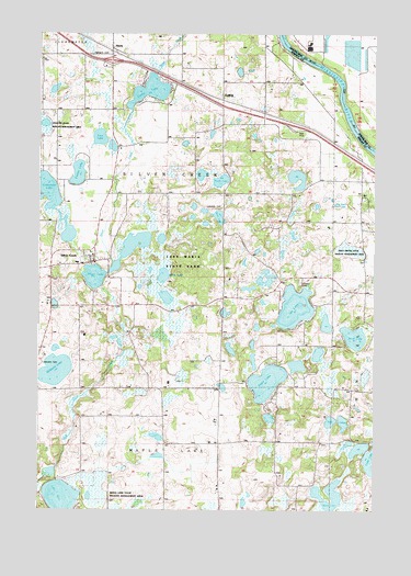
Silver Creek, MN USGS Topographic Map
Click on map above to begin viewing in our Map Viewer.

This topographic map contains these locations and features:
Feature Name Type Latitude Longitude GNIS ID View Map
Birch LakeLakeN45.2956°W93.8825°640169View Map
Black LakeLakeN45.3316°W93.8911°640214View Map
Black LakeLakeN45.2514°W93.8926°640221View Map
Carter SchoolSchoolN45.3361°W93.9725°640941View Map
Eagle LakeLakeN45.2838°W93.9149°643018View Map
Ember LakeLakeN45.3383°W93.9857°643328View Map
EnfieldPopulated PlaceN45.3575°W93.9314°643374View Map
Enfield East Bound Rest AreaLocaleN45.3500°W93.9056°2067526View Map
Enfield Post Office (historical)Post OfficeN45.3575°W93.9311°2067355View Map
Front Line Plus Fire and RescueBuildingN45.2669°W93.8761°2666108View Map
HastyPopulated PlaceN45.3711°W93.9730°644716View Map
Hasty (historical)LocaleN45.3711°W93.9728°2067348View Map
Hasty Post Office (historical)Post OfficeN45.3711°W93.9728°2067349View Map
Highland CemeteryCemeteryN45.3694°W93.9777°644946View Map
Ida LakeLakeN45.3033°W93.9046°645329View Map
Immanuel Lutheran Church of Silver CreekChurchN45.3150°W93.9794°2067464View Map
Interchange 183CrossingN45.3681°W93.9733°2067520View Map
Kelly Meyer State Wildlife Management AreaParkN45.3186°W93.8844°1815399View Map
Lake Maria State ParkParkN45.3139°W93.9572°1815398View Map
Lake MaryLakeN45.2531°W93.9915°647600View Map
Lakeside CemeteryCemeteryN45.3294°W93.9319°646414View Map
Limestone LakeLakeN45.3315°W93.9972°646667View Map
Locke LakeLakeN45.3600°W93.9592°646989View Map
Maple Lake State Wildlife Management AreaParkN45.2511°W93.9780°1815404View Map
Maria LakeLakeN45.3115°W93.9537°647523View Map
Millstone LakeLakeN45.2873°W93.9938°647890View Map
Minnesotas Highways Historical MarkerParkN45.3500°W93.9056°2067525View Map
North LakeLakeN45.3363°W93.9329°648662View Map
Olsons CampgroundLocaleN45.3333°W93.9914°2067395View Map
Silver CreekPopulated PlaceN45.3150°W93.9797°652026View Map
Silver Creek Census Designated PlaceCensusN45.3127°W93.9827°2628692View Map
Silver Creek ChurchChurchN45.3327°W93.9322°652044View Map
Silver Creek Post OfficePost OfficeN45.3150°W93.9794°2067530View Map
Silver LakeLakeN45.3112°W93.9795°652053View Map
Township of Silver CreekCivilN45.3294°W93.9519°665614View Map
Twin LakeLakeN45.3476°W93.9780°653420View Map
Twin LakesLakeN45.2731°W93.8867°653435View Map
West LakeLakeN45.3272°W93.9337°653975View Map

Note: Coordinates in the location and feature list above are referenced to NAD83 datum.


Copyright (C) 2008-2024 Ryan Niemi / Sunset Dynamics ... All Rights Reserved