TopoQuest Logo
Do you find TopoQuest useful?
Help keep TopoQuest running and adding new maps/features by donating!
Bitcoin:  19c7KJd3qBynnjoSw5npx9KScwjBe4ifkT
Litecoin:  LXs6TkuXGGXo1vDsWCkWVdjQX94eUKd6ui
Home View Maps Find Maps Find Places Resources & Links


Buffalo West, Minnesota Topographic Map

USGS Map Title: Buffalo West, MN
USGS Map MRC: 45093B8
DRG (GeoTIFF) Download: o45093b8.tif


Neighboring USGS Topographic Map Quads:


  Annandale, MN  
45094C1
 

  Silver Creek, MN  
45093C8
 

  Monticello, MN  
45093C7
 

  Albion Center, MN  
45094B1
 

  Buffalo West, MN  
45093B8
 

  Buffalo East, MN  
45093B7
 

  Howard Lake, MN  
45094A1
 

  Waverly, MN  
45093A8
 

  Delano, MN  
45093A7


Map MRC Location:

N46°
W94°
N46°
W93°
H8 H7 H6 H5 H4 H3 H2 H1
G8 G7 G6 G5 G4 G3 G2 G1
F8 F7 F6 F5 F4 F3 F2 F1
E8 E7 E6 E5 E4 E3 E2 E1
D8 D7 D6 D5 D4 D3 D2 D1
C8 C7 C6 C5 C4 C3 C2 C1
B8 B7 B6 B5 B4 B3 B2 B1
A8 A7 A6 A5 A4 A3 A2 A1
N45°
W94°
N45°
W93°

Buffalo West, MN USGS 1:24K Topographic Map Preview:
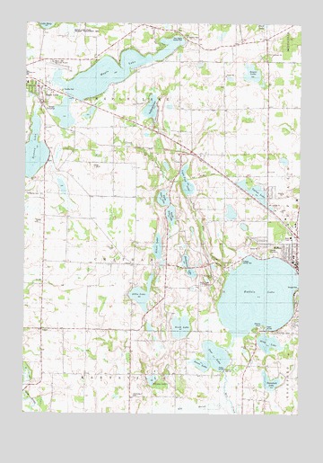
Buffalo West, MN USGS Topographic Map
Click on map above to begin viewing in our Map Viewer.

This topographic map contains these locations and features:
Feature Name Type Latitude Longitude GNIS ID View Map
Abbie LakeLakeN45.1632°W93.9465°639185View Map
Albert LakeLakeN45.1784°W93.9395°639244View Map
Angus LakeLakeN45.2336°W93.8972°639374View Map
Berthiaume LakeLakeN45.1740°W93.9269°1815396View Map
Big MarshSwampN45.1255°W93.9336°1815390View Map
Birch LakeLakeN45.1528°W93.9286°640168View Map
Buffalo City HallBuildingN45.1756°W93.8758°2067308View Map
Buffalo Fire DepartmentBuildingN45.1754°W93.8760°2067307View Map
Buffalo Foot ClinicHospitalN45.1719°W93.8753°2067292View Map
Buffalo LakeLakeN45.1630°W93.8935°640616View Map
Buffalo Lake Seaplane BaseAirportN45.1619°W93.9108°660090View Map
Buffalo Police DepartmentBuildingN45.1755°W93.8751°2067306View Map
Buffalo Post OfficePost OfficeN45.1748°W93.8765°2067305View Map
Buffalo Public LibraryBuildingN45.1719°W93.8764°2067302View Map
Buffalo Seventh Day Adventist ChurchChurchN45.1783°W93.8764°2067289View Map
Buffalo United Methodist ChurchChurchN45.1803°W93.8889°2067283View Map
Carlson SchoolSchoolN45.1314°W93.8997°640911View Map
Deer LakeReservoirN45.1431°W93.9141°642728View Map
Deer Lake DamDamN45.1383°W93.9086°1776550View Map
Deer Lake OrchardLocaleN45.1353°W93.9286°2663725View Map
East Maple County ParkParkN45.2466°W93.9308°1815397View Map
East Maple Lake SchoolSchoolN45.2450°W93.9289°643092View Map
Ebenezer Covenant HomeHospitalN45.1747°W93.8814°2067293View Map
Fadden LakeLakeN45.1358°W93.9416°1815395View Map
Goose LakeLakeN45.1408°W93.9197°1815391View Map
KRWC-AM (Buffalo)TowerN45.1666°W93.9200°662903View Map
Light Foot LakeLakeN45.1994°W93.9267°646637View Map
Maple LakeLakeN45.2346°W93.9614°647481View Map
Maple Lake Elementary SchoolSchoolN45.2332°W93.9982°2067434View Map
Maple Lake High SchoolSchoolN45.2334°W93.9996°2432761View Map
Maple Lake Municipal Airport-Bill Mavencamp Sr FieldAirportN45.2360°W93.9856°660276View Map
Marysville CemeteryCemeteryN45.1306°W93.9510°647603View Map
Mink LakeLakeN45.1478°W93.8889°647912View Map
North Twin LakeLakeN45.1940°W93.9373°653433View Map
Northwinds Elementary SchoolSchoolN45.1842°W93.8916°2432804View Map
Old Saint Timothy CemeteryCemeteryN45.2461°W93.9286°651077View Map
Olsons PointCapeN45.1533°W93.8927°1815392View Map
Persian SchoolSchoolN45.1377°W93.9266°649311View Map
Ramsey LakeLakeN45.2084°W93.9964°649807View Map
Ramsey LakeReservoirN45.2050°W93.9886°1776555View Map
Ramsey Lake DamDamN45.2050°W93.9886°1776554View Map
RassatPopulated PlaceN45.1522°W93.9919°649832View Map
Rasset Post Office (historical)Post OfficeN45.1522°W93.9917°2067334View Map
Rolling Hills OrchardLocaleN45.1667°W93.9375°2663766View Map
Saint Charles CemeteryCemeteryN45.1950°W93.9919°650550View Map
Saint Francis Catholic ChurchChurchN45.1758°W93.8778°2067282View Map
Saint Francis CemeteryCemeteryN45.1694°W93.9142°2067230View Map
Saint Francis CemeteryCemeteryN45.1692°W93.9140°651129View Map
Saint Francis Xavier SchoolSchoolN45.2034°W93.8765°2067303View Map
Saint Timothy CemeteryCemeteryN45.2277°W93.9841°648520View Map
Saint Timothy's SchoolSchoolN45.2308°W93.9993°2067391View Map
South Twin LakeLakeN45.1889°W93.9336°1815400View Map
Sturges ParkParkN45.1652°W93.8755°1815393View Map
Sullivan LakeLakeN45.2229°W93.9433°652784View Map
Tamarack LakeLakeN45.1353°W93.8880°652998View Map
The Church of Jesus Christ of Latter Day SaintsChurchN45.1722°W93.8756°2067290View Map
Township of ChathamCivilN45.1729°W93.9549°663788View Map
Township of Maple LakeCivilN45.2386°W93.9492°664903View Map
Triangle County ParkParkN45.1744°W93.9016°1815394View Map
Varner LakeLakeN45.1964°W93.8957°653619View Map
Varner SchoolSchoolN45.2016°W93.8783°653620View Map
Vokaty-Yonak DamDamN45.2500°W93.9003°1776432View Map
Vokaty-Yonak ReservoirReservoirN45.2500°W93.9003°1776433View Map
Wild Marsh Golf CourseLocaleN45.1489°W93.8811°2067318View Map
Wright CountyCivilN45.1739°W93.9631°659530View Map
Wright County CourthouseBuildingN45.1711°W93.8778°2067309View Map

Note: Coordinates in the location and feature list above are referenced to NAD83 datum.


Copyright (C) 2008-2024 Ryan Niemi / Sunset Dynamics ... All Rights Reserved