TopoQuest Logo
Do you find TopoQuest useful?
Help keep TopoQuest running and adding new maps/features by donating!
Bitcoin:  19c7KJd3qBynnjoSw5npx9KScwjBe4ifkT
Litecoin:  LXs6TkuXGGXo1vDsWCkWVdjQX94eUKd6ui
Home View Maps Find Maps Find Places Resources & Links


Buffalo East, Minnesota Topographic Map

USGS Map Title: Buffalo East, MN
USGS Map MRC: 45093B7
DRG (GeoTIFF) Download: o45093b7.tif


Neighboring USGS Topographic Map Quads:


  Silver Creek, MN  
45093C8
 

  Monticello, MN  
45093C7
 

  Big Lake, MN  
45093C6
 

  Buffalo West, MN  
45093B8
 

  Buffalo East, MN  
45093B7
 

  Saint Michael, MN  
45093B6
 

  Waverly, MN  
45093A8
 

  Delano, MN  
45093A7
 

  Rockford, MN  
45093A6


Map MRC Location:

N46°
W94°
N46°
W93°
H8 H7 H6 H5 H4 H3 H2 H1
G8 G7 G6 G5 G4 G3 G2 G1
F8 F7 F6 F5 F4 F3 F2 F1
E8 E7 E6 E5 E4 E3 E2 E1
D8 D7 D6 D5 D4 D3 D2 D1
C8 C7 C6 C5 C4 C3 C2 C1
B8 B7 B6 B5 B4 B3 B2 B1
A8 A7 A6 A5 A4 A3 A2 A1
N45°
W94°
N45°
W93°

Buffalo East, MN USGS 1:24K Topographic Map Preview:
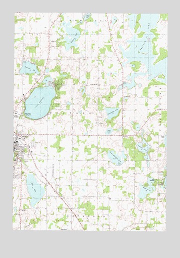
Buffalo East, MN USGS Topographic Map
Click on map above to begin viewing in our Map Viewer.

This topographic map contains these locations and features:
Feature Name Type Latitude Longitude GNIS ID View Map
Allina Medical Clinic at BuffaloHospitalN45.1958°W93.8694°2067296View Map
Bentfield Mills ParkParkN45.1639°W93.8500°2067316View Map
Booth PondReservoirN45.1333°W93.7502°1776430View Map
BuffaloPopulated PlaceN45.1719°W93.8747°640603View Map
BuffaloLocaleN45.1778°W93.8722°2067433View Map
Buffalo - Hanover- Montrose Special Education OfficeSchoolN45.1743°W93.8744°2433442View Map
Buffalo Assembly of God ChurchChurchN45.1739°W93.8722°2067280View Map
Buffalo ClinicHospitalN45.1969°W93.8700°2067297View Map
Buffalo Community Middle SchoolSchoolN45.1903°W93.8729°2067313View Map
Buffalo Covenant ChurchChurchN45.1958°W93.8728°2067288View Map
Buffalo Free Evangelical ChurchChurchN45.2236°W93.8472°2067285View Map
Buffalo Heights Golf CourseLocaleN45.1608°W93.8700°2067319View Map
Buffalo High SchoolSchoolN45.1821°W93.8299°2067311View Map
Buffalo HospitalHospitalN45.1944°W93.8709°2067295View Map
Buffalo Manor EastPopulated PlaceN45.1750°W93.8575°2067300View Map
Buffalo Municipal AirportAirportN45.1591°W93.8433°660088View Map
Buffalo Presbyterian ChurchChurchN45.1583°W93.8472°2067286View Map
Buffalo Rodeo GroundsLocaleN45.1569°W93.8481°2067310View Map
Buffalo Unitarian Universalist ChurchChurchN45.2150°W93.8500°2067284View Map
Bufflao ManorPopulated PlaceN45.1750°W93.8592°2067301View Map
Camp GreenwoodLocaleN45.1544°W93.7589°640802View Map
Centennial Fire StationBuildingN45.1725°W93.8480°2666640View Map
City of BuffaloCivilN45.1786°W93.8663°2393453View Map
Constance LakeLakeN45.2179°W93.8635°641448View Map
Discovery Elementary SchoolSchoolN45.1753°W93.8739°2067315View Map
Elletson SchoolSchoolN45.2233°W93.8219°643281View Map
Gilchrist LakeLakeN45.2361°W93.8286°644134View Map
Green Mountain LakeLakeN45.1673°W93.7911°644422View Map
Griffing ParkParkN45.1905°W93.8664°644483View Map
Honey Bee Apple OrchardLocaleN45.1411°W93.7936°2663760View Map
Hosanna Lutheran ChurchChurchN45.1967°W93.8722°2067287View Map
Ilstrup SchoolSchoolN45.1364°W93.8689°645338View Map
Immanuel CemeteryCemeteryN45.1789°W93.7858°2067231View Map
Kobbe SchoolSchoolN45.1722°W93.8277°646222View Map
Lake PulaskiLakeN45.1982°W93.8543°649756View Map
Lake Pulaski Seaplane BaseAirportN45.1983°W93.8447°660089View Map
Lakeview CemeteryCemeteryN45.1644°W93.8669°1815388View Map
Little Pulaski LakeLakeN45.2109°W93.8480°2067320View Map
Mary LakeLakeN45.1481°W93.8575°647589View Map
Middagh SchoolSchoolN45.2377°W93.8583°647797View Map
Mission CemeteryCemeteryN45.1577°W93.8694°1815387View Map
Moore LakeLakeN45.1494°W93.7663°648062View Map
Paradise LakeLakeN45.2481°W93.8163°649141View Map
Park View Care CenterHospitalN45.1653°W93.8733°2067294View Map
Parkside Elementary SchoolSchoolN45.1756°W93.8728°2067314View Map
Pelican LakeLakeN45.2293°W93.7614°649237View Map
Pelican Lake CemeteryCemeteryN45.2080°W93.8072°649240View Map
Pelican Lake ChurchChurchN45.1797°W93.7855°649242View Map
Pelican Lake SchoolSchoolN45.2033°W93.7858°649243View Map
Phoenix Learning CenterSchoolN45.1797°W93.8638°2433274View Map
Pohl LakeLakeN45.1821°W93.7974°651293View Map
Pulaski Mobile Home ParkPopulated PlaceN45.1719°W93.8744°2067299View Map
Reorganized Church of Jesus Christ of Latter Day SaintsChurchN45.2014°W93.8736°2067304View Map
Russell Booth DamDamN45.1333°W93.7502°1776429View Map
Saint John's Lutheran ChurchChurchN45.1739°W93.8717°2067281View Map
Saint Marks CemeteryCemeteryN45.2022°W93.7858°650819View Map
Schmidt LakeLakeN45.1726°W93.7680°651292View Map
Schmidt SchoolSchoolN45.1794°W93.7964°651298View Map
Soo Line DepotBuildingN45.1792°W93.8717°2067298View Map
Spirit of Joy Lutheran ChurchChurchN45.1861°W93.8486°2067432View Map
Tatanka Elementary SchoolSchoolN45.1813°W93.8648°2067312View Map
Thompson SchoolSchoolN45.1422°W93.7869°653166View Map
Township of BuffaloCivilN45.1981°W93.8182°663696View Map
Washington LakeLakeN45.1929°W93.7954°653802View Map
West Pulaski ParkParkN45.2022°W93.8628°2067317View Map
Woods Edge ApplesLocaleN45.2208°W93.8494°2663772View Map
Wright County Heritage CenterBuildingN45.2053°W93.8628°2067291View Map
Wright County JailBuildingN45.2080°W93.8637°2758756View Map
Wright County Sheriff's OfficeBuildingN45.2080°W93.8637°2758593View Map
Wright County Waterfowl Production AreaParkN45.2362°W93.7879°2765565View Map
Wright Technical CenterSchoolN45.1918°W93.8731°1815389View Map
Zion CemeteryCemeteryN45.1363°W93.8686°1815386View Map
Zion Lutheran ChurchChurchN45.1569°W93.8672°2067279View Map

Note: Coordinates in the location and feature list above are referenced to NAD83 datum.


Copyright (C) 2008-2024 Ryan Niemi / Sunset Dynamics ... All Rights Reserved