TopoQuest Logo
Do you find TopoQuest useful?
Help keep TopoQuest running and adding new maps/features by donating!
Bitcoin:  19c7KJd3qBynnjoSw5npx9KScwjBe4ifkT
Litecoin:  LXs6TkuXGGXo1vDsWCkWVdjQX94eUKd6ui
Home View Maps Find Maps Find Places Resources & Links


Montrose, Missouri Topographic Map

USGS Map Title: Montrose, MO
USGS Map MRC: 38093C8
DRG (GeoTIFF) Download: o38093c8.tif


Neighboring USGS Topographic Map Quads:


  Creighton, MO  
38094D1
 

  Hartwell, MO  
38093D8
 

  Clinton North, MO  
38093D7
 

  Johnstown, MO  
38094C1
 

  Montrose, MO  
38093C8
 

  Clinton South, MO  
38093C7
 

  Appleton City, MO  
38094B1
 

  Monegaw Springs NW, MO  
38093B8
 

  Ohio, MO  
38093B7


Map MRC Location:

N39°
W94°
N39°
W93°
H8 H7 H6 H5 H4 H3 H2 H1
G8 G7 G6 G5 G4 G3 G2 G1
F8 F7 F6 F5 F4 F3 F2 F1
E8 E7 E6 E5 E4 E3 E2 E1
D8 D7 D6 D5 D4 D3 D2 D1
C8 C7 C6 C5 C4 C3 C2 C1
B8 B7 B6 B5 B4 B3 B2 B1
A8 A7 A6 A5 A4 A3 A2 A1
N38°
W94°
N38°
W93°

Montrose, MO USGS 1:24K Topographic Map Preview:
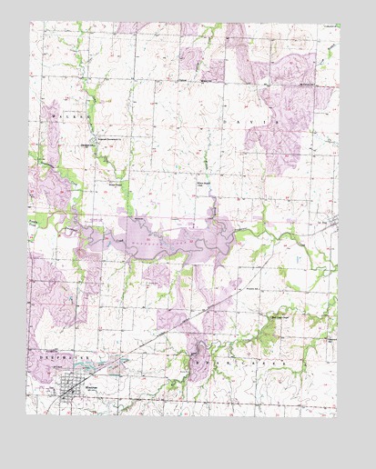
Montrose, MO USGS Topographic Map
Click on map above to begin viewing in our Map Viewer.

This topographic map contains these locations and features:
Feature Name Type Latitude Longitude GNIS ID View Map
Bear Creek CemeteryCemeteryN38.2809°W93.9019°2702277View Map
Bear Creek ChapelChurchN38.2817°W93.9019°713812View Map
Brushy CreekStreamN38.3096°W93.9954°714895View Map
Calhoun Landing Strip (historical)AirportN38.2600°W93.9913°743213View Map
Camp Branch School (historical)SchoolN38.3714°W93.9839°715254View Map
Camp CreekStreamN38.3014°W93.9413°715258View Map
City of MontroseCivilN38.2587°W93.9828°2395391View Map
Cleveland School (historical)SchoolN38.3357°W93.9737°715969View Map
Davis Elementary SchoolSchoolN38.3366°W93.8864°2743846View Map
DelmarPopulated PlaceN38.3567°W93.9422°754122View Map
Elm Branch School (historical)SchoolN38.3334°W93.8772°745472View Map
Farmers Institute (historical)SchoolN38.2836°W93.9424°745473View Map
Franklin School (historical)SchoolN38.2906°W93.9069°718171View Map
Glenwood School (historical)SchoolN38.2747°W93.8788°718526View Map
Granddaddy CreekStreamN38.3061°W93.9749°729744View Map
Hopewell CemeteryCemeteryN38.3383°W93.9716°2702281View Map
Hopewell-Cumberland ChurchChurchN38.3384°W93.9727°719815View Map
La DuePopulated PlaceN38.3125°W93.8769°720712View Map
Lonevalle School (historical)SchoolN38.2550°W93.9352°745474View Map
MontrosePopulated PlaceN38.2578°W93.9813°722551View Map
Montrose Conservation AreaParkN38.3097°W93.9702°742932View Map
Montrose Elementary SchoolSchoolN38.2552°W93.9774°2743850View Map
Montrose High SchoolSchoolN38.2550°W93.9779°2743849View Map
Montrose LakeReservoirN38.3084°W93.9169°758398View Map
Montrose Lake DamDamN38.3084°W93.9169°763031View Map
Montrose Police DepartmentBuildingN38.2575°W93.9812°2752189View Map
Montrose Post OfficePost OfficeN38.2573°W93.9796°2779503View Map
Montrose School (historical)SchoolN38.2609°W93.9833°745486View Map
Montrose Volunteer Fire DepartmentBuildingN38.2563°W93.9826°2621555View Map
Morris MineMineN38.2642°W93.9341°722651View Map
Mound School (historical)SchoolN38.3567°W93.9313°722697View Map
Mount Carmel School (historical)SchoolN38.3556°W93.8858°722740View Map
Mount Hope School (historical)SchoolN38.2920°W93.9794°745471View Map
Saint Mary CemeteryCemeteryN38.2703°W93.9930°725816View Map
Stones ChapelChurchN38.3242°W93.9680°729818View Map
Township of Bear CreekCivilN38.2539°W93.9077°766733View Map
Township of DavisCivilN38.3410°W93.9037°766738View Map
Vickers CemeteryCemeteryN38.2924°W93.9518°728181View Map
Village of La DueCivilN38.3125°W93.8777°2398363View Map
Willow BranchStreamN38.3203°W93.9273°728920View Map
Willow Branch School (historical)SchoolN38.3233°W93.9319°728937View Map

Note: Coordinates in the location and feature list above are referenced to NAD83 datum.


Copyright (C) 2008-2025 Ryan Niemi / Sunset Dynamics ... All Rights Reserved