TopoQuest Logo
Do you find TopoQuest useful?
Help keep TopoQuest running and adding new maps/features by donating!
Bitcoin:  19c7KJd3qBynnjoSw5npx9KScwjBe4ifkT
Litecoin:  LXs6TkuXGGXo1vDsWCkWVdjQX94eUKd6ui
Home View Maps Find Maps Find Places Resources & Links


Johnstown, Missouri Topographic Map

USGS Map Title: Johnstown, MO
USGS Map MRC: 38094C1
DRG (GeoTIFF) Download: o38094c1.tif


Neighboring USGS Topographic Map Quads:


  Dayton, MO  
38094D2
 

  Creighton, MO  
38094D1
 

  Hartwell, MO  
38093D8
 

  Spruce, MO  
38094C2
 

  Johnstown, MO  
38094C1
 

  Montrose, MO  
38093C8
 

  Pleasant Gap, MO  
38094B2
 

  Appleton City, MO  
38094B1
 

  Monegaw Springs NW, MO  
38093B8


Map MRC Location:

N39°
W95°
N39°
W94°
H8 H7 H6 H5 H4 H3 H2 H1
G8 G7 G6 G5 G4 G3 G2 G1
F8 F7 F6 F5 F4 F3 F2 F1
E8 E7 E6 E5 E4 E3 E2 E1
D8 D7 D6 D5 D4 D3 D2 D1
C8 C7 C6 C5 C4 C3 C2 C1
B8 B7 B6 B5 B4 B3 B2 B1
A8 A7 A6 A5 A4 A3 A2 A1
N38°
W95°
N38°
W94°

Johnstown, MO USGS 1:24K Topographic Map Preview:
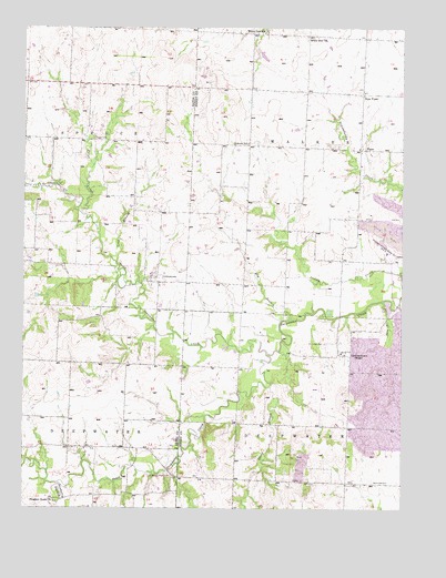
Johnstown, MO USGS Topographic Map
Click on map above to begin viewing in our Map Viewer.

This topographic map contains these locations and features:
Feature Name Type Latitude Longitude GNIS ID View Map
American School (historical)SchoolN38.3256°W94.0147°745468View Map
Antioch CreekStreamN38.3103°W94.0938°713344View Map
Aurora School (historical)SchoolN38.3449°W94.0513°713488View Map
Brownsberger AirportAirportN38.3039°W94.0513°2679366View Map
Davis BranchStreamN38.2820°W94.0436°716701View Map
Elm BranchStreamN38.2993°W94.0370°717496View Map
Enterprise School (historical)SchoolN38.2578°W94.0474°745470View Map
GermantownPopulated PlaceN38.2900°W94.0188°718417View Map
Grange Hall School (historical)SchoolN38.3437°W94.0147°745059View Map
Horn BranchStreamN38.3039°W94.0072°719830View Map
JohnstownPopulated PlaceN38.3100°W94.0824°740971View Map
Johnstown School (historical)SchoolN38.3153°W94.0842°720388View Map
Long BranchStreamN38.3153°W94.0972°721496View Map
Maple Grove School (historical)SchoolN38.2868°W94.0497°745469View Map
Montrose CemeteryCemeteryN38.2574°W94.0038°722552View Map
New PiperPopulated PlaceN38.3578°W94.0138°741100View Map
Newberry BranchStreamN38.2556°W94.1105°723330View Map
North Deepwater CreekStreamN38.2903°W94.0452°723440View Map
PiperPopulated PlaceN38.3436°W94.0147°741156View Map
Pleasant Home ChurchChurchN38.2520°W94.1149°724561View Map
Poage CemeteryCemeteryN38.3461°W94.1030°724679View Map
Poage CreekStreamN38.3270°W94.1069°724680View Map
Saint Ludger CemeteryCemeteryN38.2930°W94.0253°725815View Map
Saint Ludger ChurchChurchN38.2906°W94.0202°745485View Map
Snodgrass Union CemeteryCemeteryN38.2584°W94.0763°726669View Map
Soap CreekStreamN38.3339°W94.1208°726682View Map
South Deepwater CreekStreamN38.2903°W94.0455°726716View Map
Township of DeepwaterCivilN38.2568°W94.0183°766739View Map
Township of WalkerCivilN38.3437°W94.0143°766749View Map
White Oak ChurchChurchN38.3728°W94.0327°728744View Map
White Oak School (historical)SchoolN38.3737°W94.0461°728758View Map
Willow Tree School (historical)SchoolN38.2656°W94.1016°746029View Map

Note: Coordinates in the location and feature list above are referenced to NAD83 datum.


Copyright (C) 2008-2025 Ryan Niemi / Sunset Dynamics ... All Rights Reserved