TopoQuest Logo
Do you find TopoQuest useful?
Help keep TopoQuest running and adding new maps/features by donating!
Bitcoin:  19c7KJd3qBynnjoSw5npx9KScwjBe4ifkT
Litecoin:  LXs6TkuXGGXo1vDsWCkWVdjQX94eUKd6ui
Home View Maps Find Maps Find Places Resources & Links


Clinton North, Missouri Topographic Map

USGS Map Title: Clinton North, MO
USGS Map MRC: 38093D7
DRG (GeoTIFF) Download: o38093d7.tif


Neighboring USGS Topographic Map Quads:


  Blairstown, MO  
38093E8
 

  Chilhowee, MO  
38093E7
 

  Leeton, MO  
38093E6
 

  Hartwell, MO  
38093D8
 

  Clinton North, MO  
38093D7
 

  Calhoun West, MO  
38093D6
 

  Montrose, MO  
38093C8
 

  Clinton South, MO  
38093C7
 

  Gaines, MO  
38093C6


Map MRC Location:

N39°
W94°
N39°
W93°
H8 H7 H6 H5 H4 H3 H2 H1
G8 G7 G6 G5 G4 G3 G2 G1
F8 F7 F6 F5 F4 F3 F2 F1
E8 E7 E6 E5 E4 E3 E2 E1
D8 D7 D6 D5 D4 D3 D2 D1
C8 C7 C6 C5 C4 C3 C2 C1
B8 B7 B6 B5 B4 B3 B2 B1
A8 A7 A6 A5 A4 A3 A2 A1
N38°
W94°
N38°
W93°

Clinton North, MO USGS 1:24K Topographic Map Preview:
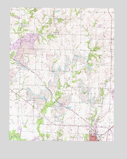
Clinton North, MO USGS Topographic Map
Click on map above to begin viewing in our Map Viewer.

This topographic map contains these locations and features:
Feature Name Type Latitude Longitude GNIS ID View Map
Antioch CemeteryCemeteryN38.3957°W93.7731°713313View Map
Beaty LakeReservoirN38.4967°W93.8202°763066View Map
Beaty Ranch Lake DamDamN38.4967°W93.8202°763065View Map
Collins School (historical)SchoolN38.4406°W93.8252°716131View Map
Comer School (historical)SchoolN38.4809°W93.7541°716150View Map
Cottonwood BranchStreamN38.4684°W93.8621°739100View Map
Curtis School (historical)SchoolN38.4425°W93.7533°716608View Map
East Fork Honey CreekStreamN38.4986°W93.8530°717286View Map
Eastgate Shopping CenterLocaleN38.3878°W93.7705°742612View Map
Ferros Ranch-AeroAirportN38.4103°W93.8513°758642View Map
Fields Creek CemeteryCemeteryN38.4040°W93.8208°717903View Map
Fields Creek School (historical)SchoolN38.4067°W93.8197°717904View Map
Freeman CemeteryCemeteryN38.4847°W93.8210°718207View Map
GarlandPopulated PlaceN38.4434°W93.8541°735966View Map
Garland School (historical)SchoolN38.4428°W93.8630°718345View Map
George Bud Church Memorial Hospital HeliportAirportN38.3917°W93.7627°758644View Map
Golden Valley Memorial HospitalHospitalN38.3893°W93.7685°2655052View Map
HarveyPopulated PlaceN38.4459°W93.8669°729749View Map
Henry CountyCivilN38.3852°W93.7927°758496View Map
HuntingdalePopulated PlaceN38.4767°W93.8172°720023View Map
Huntingdale School (historical)SchoolN38.4761°W93.8187°745063View Map
KDKD-AM (Clinton)TowerN38.3986°W93.7722°754283View Map
Land School (historical)SchoolN38.4075°W93.7649°720784View Map
Lincoln School (historical)SchoolN38.3794°W93.7770°721085View Map
LivingstonPopulated PlaceN38.4078°W93.8108°741019View Map
North ClintonLocaleN38.3789°W93.7672°740246View Map
Paul CemeteryCemeteryN38.4738°W93.8251°724103View Map
Paul CemeteryCemeteryN38.4772°W93.8482°724104View Map
Poague State Wildlife AreaParkN38.4134°W93.8399°742784View Map
QuarlesPopulated PlaceN38.4709°W93.7538°741182View Map
Rives County (historical)CivilN38.3834°W93.7835°1848181View Map
Russell School (historical)SchoolN38.3759°W93.8238°725686View Map
Township of Fields CreekCivilN38.4211°W93.7905°766742View Map
White School (historical)SchoolN38.4106°W93.8644°728768View Map

Note: Coordinates in the location and feature list above are referenced to NAD83 datum.


Copyright (C) 2008-2024 Ryan Niemi / Sunset Dynamics ... All Rights Reserved