TopoQuest Logo
Do you find TopoQuest useful?
Help keep TopoQuest running and adding new maps/features by donating!
Bitcoin:  19c7KJd3qBynnjoSw5npx9KScwjBe4ifkT
Litecoin:  LXs6TkuXGGXo1vDsWCkWVdjQX94eUKd6ui
Home View Maps Find Maps Find Places Resources & Links


Monument Peak, Montana Topographic Map

USGS Map Title: Monument Peak, MT
USGS Map MRC: 46111H1
DRG (GeoTIFF) Download: o46111h1.tif


Neighboring USGS Topographic Map Quads:


  Deep Creek Park, MT  
47111A2
 

  Blankenbaker Flats, MT  
47111A1
 

  Thunder Mountain, MT  
47110A8
 

  Bald Hills, MT  
46111H2
 

  Monument Peak, MT  
46111H1
 

  Bubbling Springs, MT  
46110H8
 

  Devils Footstool, MT  
46111G2
 

  Sheep Mountain, MT  
46111G1
 

  Strawberry Butte, MT  
46110G8


Map MRC Location:

N47°
W112°
N47°
W111°
H8 H7 H6 H5 H4 H3 H2 H1
G8 G7 G6 G5 G4 G3 G2 G1
F8 F7 F6 F5 F4 F3 F2 F1
E8 E7 E6 E5 E4 E3 E2 E1
D8 D7 D6 D5 D4 D3 D2 D1
C8 C7 C6 C5 C4 C3 C2 C1
B8 B7 B6 B5 B4 B3 B2 B1
A8 A7 A6 A5 A4 A3 A2 A1
N46°
W112°
N46°
W111°

Monument Peak, MT USGS 1:24K Topographic Map Preview:
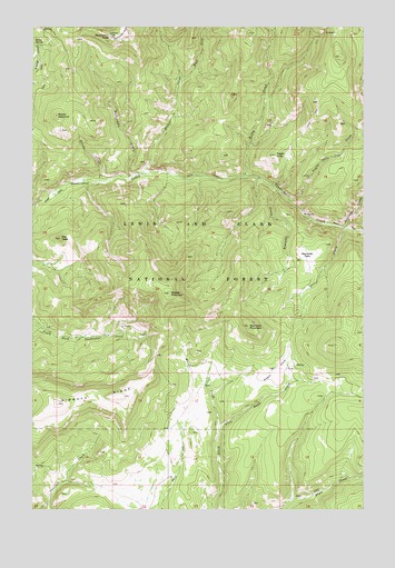
Monument Peak, MT USGS Topographic Map
Click on map above to begin viewing in our Map Viewer.

This topographic map contains these locations and features:
Feature Name Type Latitude Longitude GNIS ID View Map
Balsinger CreekStreamN46.9480°W111.0074°779317View Map
Devils CreekStreamN46.9600°W111.1002°782326View Map
Eagle ParkFlatN46.9108°W111.0338°782761View Map
East Fork Fisher CreekStreamN46.9861°W111.0697°782845View Map
Fisher CreekStreamN46.9622°W111.0838°783451View Map
Monument ParkFlatN46.9980°W111.0913°787597View Map
Monument PeakSummitN46.9975°W111.0974°787600View Map
Mount VesuviusSummitN46.9772°W111.1169°792699View Map
NW NW Section 30 MineMineN46.9519°W111.0230°804694View Map
Packsaddle CreekStreamN46.9613°W111.0886°788563View Map
Reynolds CreekStreamN46.9580°W111.0333°789546View Map
Reynolds MountainSummitN46.9227°W111.0441°789548View Map
Reynolds ParkFlatN46.9400°W111.0213°789550View Map
Rugby CreekStreamN46.9613°W111.0463°789845View Map
Sky PeakSummitN46.9452°W111.1152°790618View Map
Taylor CreekStreamN46.9555°W111.0291°791906View Map
Taylor HillsSummitN46.9666°W111.0338°791920View Map
Urvi CreekStreamN46.9480°W111.0072°777952View Map
Woods CreekStreamN46.8966°W111.0555°793512View Map
Woods MountainSummitN46.9311°W111.0738°793522View Map

Note: Coordinates in the location and feature list above are referenced to NAD83 datum.


Copyright (C) 2008-2025 Ryan Niemi / Sunset Dynamics ... All Rights Reserved