TopoQuest Logo
Do you find TopoQuest useful?
Help keep TopoQuest running and adding new maps/features by donating!
Bitcoin:  19c7KJd3qBynnjoSw5npx9KScwjBe4ifkT
Litecoin:  LXs6TkuXGGXo1vDsWCkWVdjQX94eUKd6ui
Home View Maps Find Maps Find Places Resources & Links


Blankenbaker Flats, Montana Topographic Map

USGS Map Title: Blankenbaker Flats, MT
USGS Map MRC: 47111A1
DRG (GeoTIFF) Download: o47111a1.tif


Neighboring USGS Topographic Map Quads:


  Calvert, MT  
47111B2
 

  Evans, MT  
47111B1
 

  Riceville, MT  
47110B8
 

  Deep Creek Park, MT  
47111A2
 

  Blankenbaker Flats, MT  
47111A1
 

  Thunder Mountain, MT  
47110A8
 

  Bald Hills, MT  
46111H2
 

  Monument Peak, MT  
46111H1
 

  Bubbling Springs, MT  
46110H8


Map MRC Location:

N48°
W112°
N48°
W111°
H8 H7 H6 H5 H4 H3 H2 H1
G8 G7 G6 G5 G4 G3 G2 G1
F8 F7 F6 F5 F4 F3 F2 F1
E8 E7 E6 E5 E4 E3 E2 E1
D8 D7 D6 D5 D4 D3 D2 D1
C8 C7 C6 C5 C4 C3 C2 C1
B8 B7 B6 B5 B4 B3 B2 B1
A8 A7 A6 A5 A4 A3 A2 A1
N47°
W112°
N47°
W111°

Blankenbaker Flats, MT USGS 1:24K Topographic Map Preview:
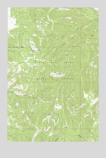
Blankenbaker Flats, MT USGS Topographic Map
Click on map above to begin viewing in our Map Viewer.

This topographic map contains these locations and features:
Feature Name Type Latitude Longitude GNIS ID View Map
Big Timber GulchValleyN47.0600°W111.0441°779890View Map
Blankenbaker FlatsFlatN47.0736°W111.1036°780099View Map
Carbonate (historical)LocaleN47.0194°W111.0013°1762400View Map
Deep Creek Figure 8 Loop National Recreation TrailTrailN47.0416°W111.0925°793969View Map
Dry GulchValleyN47.0944°W111.0175°782624View Map
Logging Creek CampgroundLocaleN47.0975°W111.0130°786457View Map
Long CouleeValleyN47.0463°W111.0566°786519View Map
Mill CreekStreamN47.0375°W111.0652°787353View Map
Monument RidgeRidgeN47.0180°W111.0952°787602View Map
Sprague GulchValleyN47.0547°W111.0516°791187View Map
Toms GulchValleyN47.1147°W111.0141°792263View Map
Wagner GulchValleyN47.0963°W111.0180°792746View Map
Wild Rock CanyonValleyN47.0625°W111.0441°793294View Map
Wood GulchValleyN47.0805°W111.0324°793485View Map

Note: Coordinates in the location and feature list above are referenced to NAD83 datum.


Copyright (C) 2008-2025 Ryan Niemi / Sunset Dynamics ... All Rights Reserved