TopoQuest Logo
Do you find TopoQuest useful?
Help keep TopoQuest running and adding new maps/features by donating!
Bitcoin:  19c7KJd3qBynnjoSw5npx9KScwjBe4ifkT
Litecoin:  LXs6TkuXGGXo1vDsWCkWVdjQX94eUKd6ui
Home View Maps Find Maps Find Places Resources & Links


Morgan Butte, Arizona Topographic Map

USGS Map Title: Morgan Butte, AZ
USGS Map MRC: 34112A5
DRG (GeoTIFF) Download: o34112a5.tif


Neighboring USGS Topographic Map Quads:


  Yarnell, AZ  
34112B6
 

  Wagoner, AZ  
34112B5
 

  Minnehaha, AZ  
34112B4
 

  Sam Powell Peak, AZ  
34112A6
 

  Morgan Butte, AZ  
34112A5
 

  Copperopolis, AZ  
34112A4
 

  Wickenburg, AZ  
33112H6
 

  Red Picacho, AZ  
33112H5
 

  Garfias Mountain, AZ  
33112H4


Map MRC Location:

N35°
W113°
N35°
W112°
H8 H7 H6 H5 H4 H3 H2 H1
G8 G7 G6 G5 G4 G3 G2 G1
F8 F7 F6 F5 F4 F3 F2 F1
E8 E7 E6 E5 E4 E3 E2 E1
D8 D7 D6 D5 D4 D3 D2 D1
C8 C7 C6 C5 C4 C3 C2 C1
B8 B7 B6 B5 B4 B3 B2 B1
A8 A7 A6 A5 A4 A3 A2 A1
N34°
W113°
N34°
W112°

Morgan Butte, AZ USGS 1:24K Topographic Map Preview:
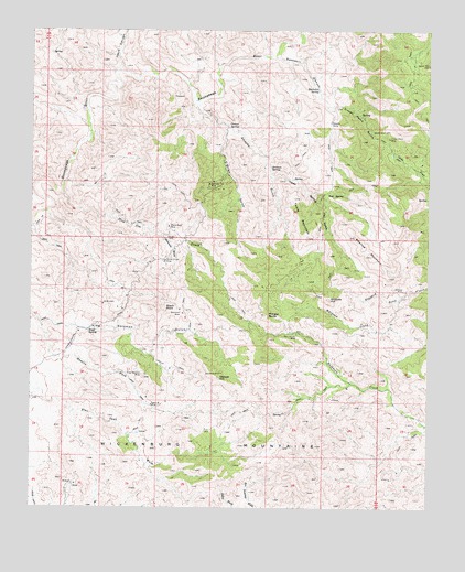
Morgan Butte, AZ USGS Topographic Map
Click on map above to begin viewing in our Map Viewer.

This topographic map contains these locations and features:
Feature Name Type Latitude Longitude GNIS ID View Map
Abe Lincoln MineMineN34.0456°W112.5421°470View Map
Amazon GulchValleyN34.1000°W112.5643°623View Map
Amazon SpringSpringN34.0884°W112.5508°624View Map
Black RockSummitN34.0523°W112.5835°1589View Map
Black Rock MineMineN34.0734°W112.5821°1604View Map
Buckskin CanyonValleyN34.1178°W112.5491°2112View Map
Buckskin SpringSpringN34.1095°W112.5357°2117View Map
Camp B MineMineN34.0270°W112.5874°2404View Map
ConstellationPopulated PlaceN34.0634°W112.5824°42812View Map
Corner SpringSpringN34.1002°W112.5608°3269View Map
Crown Point GulchValleyN34.1053°W112.5327°3607View Map
Crown Point MineMineN34.0970°W112.5132°3608View Map
Denver HillSummitN34.0339°W112.5663°3850View Map
Gold Bar MineMineN34.0848°W112.5699°5092View Map
Grooms HillSummitN34.0545°W112.5318°5396View Map
Hassayampa River Canyon WildernessReserveN34.1100°W112.6010°2035146View Map
Hawk Spring GulchValleyN34.0867°W112.5505°5632View Map
Iron SpringSpringN34.0824°W112.5325°6262View Map
Jesus CanyonValleyN34.1150°W112.5985°30530View Map
Keystone MineMineN34.0509°W112.5777°6681View Map
King Solomon MineMineN34.0350°W112.5907°6700View Map
Mahoney WashStreamN34.0714°W112.5849°7595View Map
Monte Cristo MineMineN34.0645°W112.5835°8217View Map
Monte Cristo SubstationLocaleN34.0659°W112.5866°21346View Map
Morgan ButteSummitN34.0506°W112.5516°8283View Map
O'Brien GulchValleyN34.1000°W112.5643°8839View Map
Roberts CampLocaleN34.1011°W112.5321°10360View Map
Sayer SpringSpringN34.0463°W112.6075°10994View Map
Slim Jim CreekStreamN34.0825°W112.6157°11441View Map
Swallow MineMineN34.0570°W112.5088°12026View Map
Swallow MountainSummitN34.0661°W112.5188°12027View Map
Table MountainSummitN34.0709°W112.5388°12108View Map
Wickenburg MountainsRangeN34.0339°W112.5663°13732View Map

Note: Coordinates in the location and feature list above are referenced to NAD83 datum.


Copyright (C) 2008-2024 Ryan Niemi / Sunset Dynamics ... All Rights Reserved