TopoQuest Logo
Do you find TopoQuest useful?
Help keep TopoQuest running and adding new maps/features by donating!
Bitcoin:  19c7KJd3qBynnjoSw5npx9KScwjBe4ifkT
Litecoin:  LXs6TkuXGGXo1vDsWCkWVdjQX94eUKd6ui
Home View Maps Find Maps Find Places Resources & Links


Minnehaha, Arizona Topographic Map

USGS Map Title: Minnehaha, AZ
USGS Map MRC: 34112B4
DRG (GeoTIFF) Download: o34112b4.tif


Neighboring USGS Topographic Map Quads:


  Walnut Grove, AZ  
34112C5
 

  Battleship Butte, AZ  
34112C4
 

  Battle Flat, AZ  
34112C3
 

  Wagoner, AZ  
34112B5
 

  Minnehaha, AZ  
34112B4
 

  Crown King, AZ  
34112B3
 

  Morgan Butte, AZ  
34112A5
 

  Copperopolis, AZ  
34112A4
 

  Columbia, AZ  
34112A3


Map MRC Location:

N35°
W113°
N35°
W112°
H8 H7 H6 H5 H4 H3 H2 H1
G8 G7 G6 G5 G4 G3 G2 G1
F8 F7 F6 F5 F4 F3 F2 F1
E8 E7 E6 E5 E4 E3 E2 E1
D8 D7 D6 D5 D4 D3 D2 D1
C8 C7 C6 C5 C4 C3 C2 C1
B8 B7 B6 B5 B4 B3 B2 B1
A8 A7 A6 A5 A4 A3 A2 A1
N34°
W113°
N34°
W112°

Minnehaha, AZ USGS 1:24K Topographic Map Preview:
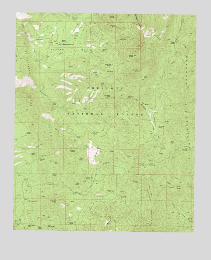
Minnehaha, AZ USGS Topographic Map
Click on map above to begin viewing in our Map Viewer.

This topographic map contains these locations and features:
Feature Name Type Latitude Longitude GNIS ID View Map
Ash CreekStreamN34.2003°W112.4168°25786View Map
Ash SpringSpringN34.1647°W112.4725°25799View Map
Baldy TrapGapN34.1953°W112.4541°25930View Map
Black Jack SpringSpringN34.2208°W112.4346°26401View Map
Boaz MineMineN34.1534°W112.4168°26561View Map
Boulder Dam SpringSpringN34.2262°W112.4223°26648View Map
Box SpringSpringN34.2362°W112.4285°26686View Map
Bull Run SpringSpringN34.1731°W112.3812°26970View Map
Button MineMineN34.1659°W112.4054°27100View Map
Camp Bird MineMineN34.1678°W112.4816°27196View Map
Camp Bird WellWellN34.1659°W112.4824°27197View Map
Cedar SpringSpringN34.1664°W112.4527°27436View Map
Cellar BasinBasinN34.2284°W112.4627°27451View Map
Cellar Basin TrailTrailN34.2175°W112.4768°2040937View Map
Cellar SpringsSpringN34.2230°W112.4844°27453View Map
Charles SpringSpringN34.1831°W112.4688°38327View Map
Cherry Creek Trail Two Hundred FourteenTrailN34.1973°W112.4813°38329View Map
Cherry SpringSpringN34.1799°W112.4898°27553View Map
Cherry Trap SpringSpringN34.1817°W112.4465°27557View Map
Chilean MillPopulated PlaceN34.1511°W112.3932°27579View Map
Colorado SpringSpringN34.2259°W112.4435°38353View Map
Escondido SpringSpringN34.1864°W112.4341°38439View Map
Goodwin SpringSpringN34.1306°W112.4969°29417View Map
Grapevine SpringSpringN34.2422°W112.4317°29525View Map
Green Tank WindmillLocaleN34.1475°W112.4327°29578View Map
Hooper SaddleGapN34.2342°W112.3902°30098View Map
Horse MountainSummitN34.2361°W112.4116°30154View Map
Horse Mountain SpringSpringN34.2350°W112.3988°38514View Map
Horse Mountain Trail Number Two Hundred TwelveTrailN34.2398°W112.3977°38515View Map
House Water SpringSpringN34.1274°W112.4903°30241View Map
Indian SpringsSpringN34.2336°W112.4660°30372View Map
Indian Springs CampLocaleN34.2320°W112.4685°30374View Map
Indian Springs CreekStreamN34.2331°W112.4896°30376View Map
Jakies PassGapN34.2134°W112.4121°30495View Map
Jakies Pass SpringSpringN34.2167°W112.4160°30496View Map
John SpringSpringN34.2102°W112.4389°30570View Map
Johnson FlatFlatN34.1531°W112.4427°30582View Map
Johnson Flat SpringSpringN34.1550°W112.4509°30584View Map
Joker MineMineN34.1328°W112.4768°30596View Map
Juniper SpringSpringN34.1789°W112.4546°30676View Map
Lane SpringSpringN34.1269°W112.4833°30872View Map
LaphamPopulated PlaceN34.1806°W112.4021°38562View Map
LF RidgeRidgeN34.2123°W112.4607°40958View Map
LF TankReservoirN34.2158°W112.4472°30820View Map
Little Joker SpringSpringN34.1267°W112.4764°31090View Map
Log Cabin SpringSpringN34.1708°W112.4585°31180View Map
Logan Mine SpringSpringN34.1452°W112.4268°31191View Map
Lower Oak Creek WindmillLocaleN34.1420°W112.4904°31372View Map
Lucky SpringSpringN34.1520°W112.4554°31394View Map
McAllister RangeRangeN34.2134°W112.4924°31617View Map
Miller WindmillLocaleN34.1470°W112.4243°31884View Map
MinnehahaPopulated PlaceN34.1634°W112.4074°31922View Map
Minnehaha FlatFlatN34.1839°W112.4024°31924View Map
Minnehaha SpringSpringN34.2000°W112.4800°38636View Map
Minnehaha SpringSpringN34.1856°W112.4013°31925View Map
Minnehaha WatersFallsN34.2020°W112.4227°31926View Map
ML WindmillLocaleN34.1517°W112.4729°31425View Map
North Fork Cellar Springs CreekStreamN34.2231°W112.4843°32362View Map
Oak Creek SpringSpringN34.1429°W112.4713°32437View Map
Oak Creek WellWellN34.1636°W112.4377°32439View Map
Pacific MineMineN34.1320°W112.3768°32614View Map
Patterson SpringSpringN34.2283°W112.3899°32733View Map
Paxton PlacePopulated PlaceN34.1723°W112.4846°32740View Map
Pay Dirt SpringSpringN34.1633°W112.4104°32741View Map
Peter SpringSpringN34.2164°W112.4326°32818View Map
Pine CreekStreamN34.1923°W112.4071°32924View Map
Purebred SpringSpringN34.2468°W112.4615°33235View Map
Rabbit SpringSpringN34.1985°W112.4750°33306View Map
Ralphs SpringSpringN34.1575°W112.4740°33343View Map
Ridges SpringSpringN34.1692°W112.4885°33612View Map
Rock SpringSpringN34.2342°W112.4864°33725View Map
Rush SpringSpringN34.1767°W112.3926°33878View Map
Shelley PlaceLocaleN34.1931°W112.4068°38804View Map
Shelley-Pearce RanchLocaleN34.1300°W112.4957°40959View Map
Silver Dollar MineMineN34.1311°W112.4310°34439View Map
Silver Dollar SpringSpringN34.1333°W112.4326°34440View Map
Silver MountainSummitN34.1300°W112.4066°34445View Map
South Fork Cellar Springs CreekStreamN34.2234°W112.4841°34656View Map
Steamboat SpringSpringN34.2286°W112.4410°34810View Map
TB SpringSpringN34.1728°W112.4437°35087View Map
Tetterman SpringSpringN34.1300°W112.4585°35199View Map
The CementsSummitN34.1686°W112.4452°35217View Map
Thompson ButteSummitN34.2017°W112.4360°35278View Map
Upper Oak Creek WindmillLocaleN34.1467°W112.4552°35702View Map
Wagoner Trail Number Two Hundred ThirteenTrailN34.2011°W112.4174°38919View Map
Wheels CanyonValleyN34.1509°W112.3804°36045View Map
Willow SpringSpringN34.2482°W112.4327°36254View Map
Y SpringSpringN34.2278°W112.4341°38974View Map

Note: Coordinates in the location and feature list above are referenced to NAD83 datum.


Copyright (C) 2008-2025 Ryan Niemi / Sunset Dynamics ... All Rights Reserved