TopoQuest Logo
Do you find TopoQuest useful?
Help keep TopoQuest running and adding new maps/features by donating!
Bitcoin:  19c7KJd3qBynnjoSw5npx9KScwjBe4ifkT
Litecoin:  LXs6TkuXGGXo1vDsWCkWVdjQX94eUKd6ui
Home View Maps Find Maps Find Places Resources & Links


Glen Alpine, North Carolina Topographic Map

USGS Map Title: Glen Alpine, NC
USGS Map MRC: 35081F7
DRG (GeoTIFF) Download: o35081f7.tif


Neighboring USGS Topographic Map Quads:


  Ashford, NC  
35081G8
 

  Oak Hill, NC  
35081G7
 

  Morganton North, NC  
35081G6
 

  Marion East, NC  
35081F8
 

  Glen Alpine, NC  
35081F7
 

  Morganton South, NC  
35081F6
 

  Glenwood, NC  
35081E8
 

  Dysartsville, NC  
35081E7
 

  Benn Knob, NC  
35081E6


Map MRC Location:

N36°
W82°
N36°
W81°
H8 H7 H6 H5 H4 H3 H2 H1
G8 G7 G6 G5 G4 G3 G2 G1
F8 F7 F6 F5 F4 F3 F2 F1
E8 E7 E6 E5 E4 E3 E2 E1
D8 D7 D6 D5 D4 D3 D2 D1
C8 C7 C6 C5 C4 C3 C2 C1
B8 B7 B6 B5 B4 B3 B2 B1
A8 A7 A6 A5 A4 A3 A2 A1
N35°
W82°
N35°
W81°

Glen Alpine, NC USGS 1:24K Topographic Map Preview:
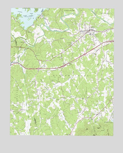
Glen Alpine, NC USGS Topographic Map
Click on map above to begin viewing in our Map Viewer.

This topographic map contains these locations and features:
Feature Name Type Latitude Longitude GNIS ID View Map
Advent CemeteryCemeteryN35.7042°W81.7886°1008659View Map
Anderson BranchStreamN35.6690°W81.8243°1008716View Map
Bethel ChurchChurchN35.6696°W81.8418°1009219View Map
Bethel Church CemeteryCemeteryN35.6694°W81.8419°2779072View Map
Brendletown Fire and Rescue Protection Association Station 1BuildingN35.6424°W81.7806°2638802View Map
Brendletown Fire and Rescue Protection Association Station 2BuildingN35.6599°W81.7828°2639150View Map
BridgewaterPopulated PlaceN35.7115°W81.8626°1009598View Map
Bridgewater DamDamN35.7435°W81.8382°1017297View Map
Bridgewater Presbyterian ChurchChurchN35.7110°W81.8620°1009599View Map
Brindle Mines (historical)LocaleN35.6907°W81.8165°1017362View Map
BrindletownPopulated PlaceN35.6251°W81.8007°1019303View Map
Broughton Hospital DamDamN35.6401°W81.7532°1017258View Map
Broughton Hospital ReservoirReservoirN35.6399°W81.7502°1017257View Map
Burke County Emergency Services Station 3BuildingN35.7284°W81.7790°2720431View Map
Chambers ChapelChurchN35.7162°W81.8001°1010157View Map
Chestnut Flat BranchStreamN35.6382°W81.7704°1010241View Map
Clear CreekStreamN35.7026°W81.7584°1010315View Map
Copening ChurchChurchN35.7268°W81.8504°1010477View Map
Dentons ChapelChurchN35.6610°W81.7526°1010787View Map
Dentons Chapel United Methodist Church CemeteryCemeteryN35.6609°W81.7532°2779076View Map
Double BranchStreamN35.6854°W81.7576°1010877View Map
Dry Pond School (historical)SchoolN35.6571°W81.8398°1960050View Map
Duke School (historical)SchoolN35.7104°W81.8004°1960051View Map
England KnobSummitN35.6329°W81.7693°1020155View Map
First Baptist Church of Glen AlpineChurchN35.7261°W81.7828°2504722View Map
Gibbs ChapelChurchN35.7057°W81.7729°1011477View Map
Gibbs Chapel CemeteryCemeteryN35.7057°W81.7730°2779069View Map
Glen AlpinePopulated PlaceN35.7290°W81.7793°1011526View Map
Glen Alpine Elementary and Junior High SchoolSchoolN35.7243°W81.7787°1017364View Map
Glen Alpine Post OfficePost OfficeN35.7291°W81.7793°2774339View Map
Glen Alpine Rural School (historical)SchoolN35.7037°W81.7865°1960052View Map
Glen Alpine Volunteer Fire DepartmentBuildingN35.7294°W81.7791°2638857View Map
Hall CreekStreamN35.6665°W81.8226°1011802View Map
Hall KnobSummitN35.6315°W81.7801°1011804View Map
Hardaway (historical)Populated PlaceN35.7168°W81.8415°1960053View Map
Henredon DamDamN35.7068°W81.7865°1017275View Map
Henredon LakeReservoirN35.7074°W81.7872°1017276View Map
Hoppers CreekStreamN35.6412°W81.8523°1012179View Map
Jack BranchStreamN35.6748°W81.8151°1012390View Map
James BranchStreamN35.6826°W81.8020°1012428View Map
Lake James DamDamN35.7445°W81.8378°1017292View Map
Linville DamDamN35.7440°W81.8368°1012891View Map
Linville RiverStreamN35.7460°W81.8365°1012897View Map
Long BranchStreamN35.6493°W81.8543°1013137View Map
Matthews Store (historical)LocaleN35.6615°W81.8407°1960054View Map
Mc Alpine SchoolSchoolN35.7021°W81.8129°1013383View Map
Mc Dowell ChurchChurchN35.6782°W81.8229°1013387View Map
Mc Elrath ChapelChurchN35.6951°W81.8020°1013388View Map
McDowell Church CemeteryCemeteryN35.6783°W81.8233°2779071View Map
McElrath Chapel CemeteryCemeteryN35.6960°W81.8013°2779070View Map
McKees Store (historical)LocaleN35.6951°W81.8398°1960055View Map
Morganton Junior AcademySchoolN35.6907°W81.8101°1017367View Map
Morrison Chapel (historical)ChurchN35.6451°W81.8195°1960056View Map
Mount Herman ChurchChurchN35.7223°W81.7868°1013739View Map
Mount Olive ChurchChurchN35.6621°W81.8090°1013756View Map
Mount Olive Church CemeteryCemeteryN35.6617°W81.8095°2779073View Map
Mountain View ChurchChurchN35.6779°W81.8440°1013804View Map
Muddy CreekStreamN35.7137°W81.8454°1013823View Map
North Muddy CreekStreamN35.6965°W81.8648°1024193View Map
Nowling ChapelChurchN35.6423°W81.7759°1014043View Map
Old Catawba RiverStreamN35.7285°W81.8257°1014092View Map
Old Paddy CreekStreamN35.7326°W81.8379°1027440View Map
Paddy Creek DamDamN35.7335°W81.8476°1014174View Map
Paddys Creek DamDamN35.7335°W81.8482°1017290View Map
ParkhillPopulated PlaceN35.7137°W81.7995°1021814View Map
PattenPopulated PlaceN35.6510°W81.8601°1014251View Map
Patton Valley AirportAirportN35.6626°W81.8729°2717298View Map
Peoples ChurchChurchN35.7349°W81.7901°1014330View Map
Pilot Mountain SchoolSchoolN35.6462°W81.7693°1014401View Map
Pinedale School (historical)SchoolN35.6593°W81.7537°1960057View Map
Pinnacle ChurchChurchN35.6496°W81.8737°1014470View Map
Pleasant Ridge CemeteryCemeteryN35.6723°W81.7704°1960058View Map
Pleasant Ridge ChurchChurchN35.6726°W81.7693°1014529View Map
Rain Hill ChurchChurchN35.6479°W81.7915°1014716View Map
Rain Hill Church CemeteryCemeteryN35.6481°W81.7923°2779074View Map
Reedy CreekStreamN35.7240°W81.8332°1014809View Map
Rollins (historical)Populated PlaceN35.6596°W81.7829°1960059View Map
Shadrick CreekStreamN35.7196°W81.8690°1015369View Map
Shoal CreekStreamN35.6551°W81.7687°1015454View Map
Snow Hill ChurchChurchN35.7040°W81.8434°1015644View Map
South Muddy CreekStreamN35.6968°W81.8651°1015703View Map
Stony RidgeRidgeN35.6260°W81.7562°1015867View Map
Sutterwhite CreekStreamN35.6590°W81.7615°1015963View Map
Town of Glen AlpineCivilN35.7307°W81.7826°2406575View Map
Township of Silver CreekCivilN35.6668°W81.8018°1026466View Map
Wesleyan Methodist ChurchChurchN35.6971°W81.7665°1017859View Map
West End Volunteer Fire DepartmentBuildingN35.6894°W81.8360°2638278View Map

Note: Coordinates in the location and feature list above are referenced to NAD83 datum.


Copyright (C) 2008-2024 Ryan Niemi / Sunset Dynamics ... All Rights Reserved