TopoQuest Logo
Do you find TopoQuest useful?
Help keep TopoQuest running and adding new maps/features by donating!
Bitcoin:  19c7KJd3qBynnjoSw5npx9KScwjBe4ifkT
Litecoin:  LXs6TkuXGGXo1vDsWCkWVdjQX94eUKd6ui
Home View Maps Find Maps Find Places Resources & Links


Oak Hill, North Carolina Topographic Map

USGS Map Title: Oak Hill, NC
USGS Map MRC: 35081G7
DRG (GeoTIFF) Download: o35081g7.tif


Neighboring USGS Topographic Map Quads:


  Linville Falls, NC  
35081H8
 

  Chestnut Mountain, NC  
35081H7
 

  Collettsville, NC  
35081H6
 

  Ashford, NC  
35081G8
 

  Oak Hill, NC  
35081G7
 

  Morganton North, NC  
35081G6
 

  Marion East, NC  
35081F8
 

  Glen Alpine, NC  
35081F7
 

  Morganton South, NC  
35081F6


Map MRC Location:

N36°
W82°
N36°
W81°
H8 H7 H6 H5 H4 H3 H2 H1
G8 G7 G6 G5 G4 G3 G2 G1
F8 F7 F6 F5 F4 F3 F2 F1
E8 E7 E6 E5 E4 E3 E2 E1
D8 D7 D6 D5 D4 D3 D2 D1
C8 C7 C6 C5 C4 C3 C2 C1
B8 B7 B6 B5 B4 B3 B2 B1
A8 A7 A6 A5 A4 A3 A2 A1
N35°
W82°
N35°
W81°

Oak Hill, NC USGS 1:24K Topographic Map Preview:
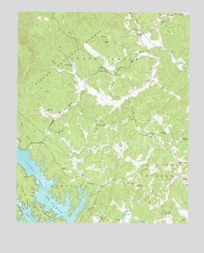
Oak Hill, NC USGS Topographic Map
Click on map above to begin viewing in our Map Viewer.

This topographic map contains these locations and features:
Feature Name Type Latitude Longitude GNIS ID View Map
Back CreekStreamN35.8290°W81.8301°1008830View Map
Fairview ChurchChurchN35.8690°W81.7684°1011139View Map
GoldPopulated PlaceN35.7932°W81.7620°1011544View Map
Goodmans LakeLakeN35.8037°W81.7655°1011562View Map
Grand View ChurchChurchN35.7721°W81.7882°1011595View Map
Henry Harris DamDamN35.8385°W81.7832°1017303View Map
Henry Harris LakeReservoirN35.8405°W81.7862°1017302View Map
JoyLocaleN35.8699°W81.7707°1017366View Map
Lake James ChurchChurchN35.7737°W81.8187°1012655View Map
Lake James Community Volunteer Fire DepartmentBuildingN35.7730°W81.8129°2638768View Map
Leibhart DamDamN35.8068°W81.8065°1017300View Map
Leibhart LakeReservoirN35.8066°W81.8052°1017301View Map
Linville ChurchChurchN35.7826°W81.8423°1012889View Map
Linville George WildernessReserveN35.8523°W81.8568°1018238View Map
Miller MountainSummitN35.8585°W81.8123°1021466View Map
Mount View ChurchChurchN35.8043°W81.8434°1013773View Map
Mountain Grove ChurchChurchN35.8415°W81.8120°1013798View Map
Oak HillPopulated PlaceN35.7787°W81.7559°1014059View Map
Oak Hill Elementary and Junior High SchoolSchoolN35.7765°W81.7568°1017368View Map
Oak Hill Fire and Rescue Protection Association Station 1BuildingN35.7790°W81.7561°2638860View Map
Oak Hill Fire and Rescue Protection Association Station 2BuildingN35.8700°W81.7708°2639155View Map
Quaker Meadow Presbyterian ChurchChurchN35.7868°W81.7568°1014677View Map
Reedys ForkStreamN35.8379°W81.8332°1014812View Map
River Valley ChurchChurchN35.7523°W81.8115°1014920View Map
Roses CreekStreamN35.8337°W81.7718°1015092View Map
Russell CreekStreamN35.8285°W81.8290°1015139View Map
Saint Pauls ChurchChurchN35.7518°W81.7995°1015166View Map
Shiloh Ame ChurchChurchN35.7696°W81.8051°1017861View Map
Simpson CreekStreamN35.8493°W81.7862°1015547View Map
Smyrna ChurchChurchN35.8629°W81.7851°1017860View Map
Steels CreekStreamN35.8640°W81.7873°1015810View Map
Table RockPopulated PlaceN35.8382°W81.8045°1022875View Map
Table Rock Fish Hatchery DamDamN35.8468°W81.8382°1017307View Map
Table Rock Fish Hatchery LakeReservoirN35.8464°W81.8375°1017306View Map
Tablerock ChurchChurchN35.8026°W81.7768°1016005View Map
Tablerock ChurchChurchN35.8165°W81.8529°1016006View Map
Tablerock State Fish HatcheryLocaleN35.8435°W81.8343°1016007View Map
Township of Upper CreekCivilN35.8725°W81.8200°1026468View Map
White CreekStreamN35.7940°W81.8659°1016583View Map
Willow Tree ChurchChurchN35.8001°W81.7515°1016709View Map
Willow Tree SchoolSchoolN35.7554°W81.7668°1016710View Map
Zion ChurchChurchN35.8132°W81.7918°1016891View Map

Note: Coordinates in the location and feature list above are referenced to NAD83 datum.


Copyright (C) 2008-2025 Ryan Niemi / Sunset Dynamics ... All Rights Reserved