TopoQuest Logo
Do you find TopoQuest useful?
Help keep TopoQuest running and adding new maps/features by donating!
Bitcoin:  19c7KJd3qBynnjoSw5npx9KScwjBe4ifkT
Litecoin:  LXs6TkuXGGXo1vDsWCkWVdjQX94eUKd6ui
Home View Maps Find Maps Find Places Resources & Links


Mount Catherine, Utah Topographic Map

USGS Map Title: Mount Catherine, UT
USGS Map MRC: 38112H2
DRG (GeoTIFF) Download: o38112h2.tif


Neighboring USGS Topographic Map Quads:


  Holden, UT  
39112A3
 

  Coffee Peak, UT  
39112A2
 

  Scipio Lake, UT  
39112A1
 

  Fillmore, UT  
38112H3
 

  Mount Catherine, UT  
38112H2
 

  Beehive Peak, UT  
38112H1
 

  Sunset Peak, UT  
38112G3
 

  White Pine Peak, UT  
38112G2
 

  Richfield, UT  
38112G1


Map MRC Location:

N39°
W113°
N39°
W112°
H8 H7 H6 H5 H4 H3 H2 H1
G8 G7 G6 G5 G4 G3 G2 G1
F8 F7 F6 F5 F4 F3 F2 F1
E8 E7 E6 E5 E4 E3 E2 E1
D8 D7 D6 D5 D4 D3 D2 D1
C8 C7 C6 C5 C4 C3 C2 C1
B8 B7 B6 B5 B4 B3 B2 B1
A8 A7 A6 A5 A4 A3 A2 A1
N38°
W113°
N38°
W112°

Mount Catherine, UT USGS 1:24K Topographic Map Preview:
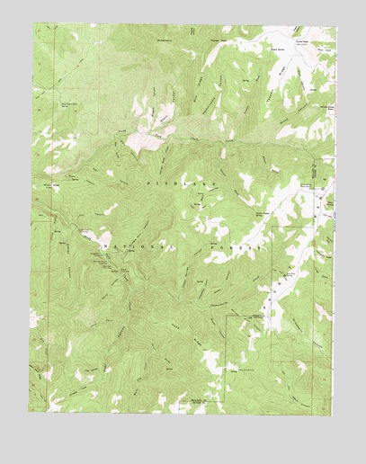
Mount Catherine, UT USGS Topographic Map
Click on map above to begin viewing in our Map Viewer.

This topographic map contains these locations and features:
Feature Name Type Latitude Longitude GNIS ID View Map
Balsam Picnic AreaLocaleN38.9208°W112.2133°1438382View Map
Balsam SpringSpringN38.9209°W112.2138°1454979View Map
Bear CanyonValleyN38.8980°W112.2147°1438453View Map
Bear HollowValleyN38.9491°W112.1691°1438472View Map
Bear Hollow SpringSpringN38.9418°W112.1833°1449939View Map
Black Cedar Hills SpringSpringN38.9743°W112.2382°1438839View Map
Blue RidgeRidgeN38.9791°W112.1833°1438949View Map
Broad CanyonValleyN38.9633°W112.1527°1439126View Map
Buck HollowValleyN38.9627°W112.2169°1439221View Map
Buckskin Charley Picnic AreaLocaleN38.9233°W112.2177°1439250View Map
Burned Point CanyonValleyN38.9105°W112.1688°1439339View Map
Cedar Springs CanyonValleyN38.9116°W112.1885°1439596View Map
Chokecherry CreekStreamN38.9144°W112.2077°1439709View Map
Copley CanyonValleyN38.9336°W112.2319°1439941View Map
Copley CreekStreamN38.9344°W112.2313°1451218View Map
Copleys Cove Picnic AreaLocaleN38.9336°W112.2308°1439942View Map
Cottonwood CanyonValleyN38.9114°W112.1808°1439990View Map
Cottonwood SpringSpringN38.9175°W112.1787°1449949View Map
Deer CanyonValleyN38.9564°W112.2285°1440362View Map
Fall CanyonValleyN38.9355°W112.2324°1440991View Map
Flat CanyonValleyN38.8947°W112.2180°1451246View Map
Hans RidgeRidgeN38.9002°W112.1835°1441578View Map
Hardscrabble CanyonValleyN38.9633°W112.1802°1441584View Map
Horse HollowValleyN38.9389°W112.2394°1441877View Map
Indian SpringsSpringN38.9475°W112.1363°1454976View Map
Indian Springs Guard StationLocaleN38.9477°W112.1358°1442034View Map
Jacks PeakSummitN38.9939°W112.1394°1442088View Map
Jacks TwistValleyN38.9022°W112.2124°1442089View Map
Lone Pine CanyonValleyN38.9222°W112.1516°1442873View Map
Lone Pine SpringSpringN38.9203°W112.1450°1442879View Map
Lost CanyonValleyN38.8889°W112.2199°1442956View Map
Magpie CanyonValleyN38.9652°W112.2027°1443074View Map
Mason GulchValleyN38.9614°W112.1555°1443223View Map
Mount CatherineSummitN38.9941°W112.1958°1439540View Map
Mountain Sheep CanyonValleyN38.9639°W112.1919°1443646View Map
Nephi CanyonValleyN38.9089°W112.1758°1443794View Map
Number Three SpringSpringN38.9300°W112.1763°1449940View Map
Number Two SpringSpringN38.9236°W112.1834°1449941View Map
Paradise CanyonValleyN38.8855°W112.2210°1451322View Map
Paradise CreekStreamN38.8852°W112.2202°1444184View Map
Pioneer PeakSummitN38.9941°W112.1735°1444448View Map
Pistol Rock Picnic AreaLocaleN38.9222°W112.2158°1444461View Map
Reece CanyonValleyN38.9661°W112.2005°1444846View Map
Rock CanyonValleyN38.9755°W112.1369°1445034View Map
Rocky CanyonValleyN38.9183°W112.2119°1445110View Map
Shingle Mill CanyonValleyN38.9272°W112.2105°1445534View Map
Shingle Mill Picnic AreaLocaleN38.9258°W112.2194°1445543View Map
Shingle Mill SpringSpringN38.9273°W112.2105°1449950View Map
Sims CanyonValleyN38.9650°W112.2149°1445607View Map
Snow CanyonValleyN38.9527°W112.2363°1445733View Map
Solitude Guard StationLocaleN38.8889°W112.1638°1445775View Map
Sugarloaf MountainSummitN38.9166°W112.1674°1449079View Map
Teeples RidgeRidgeN38.9827°W112.1485°1446370View Map
Teeples SpringSpringN38.9922°W112.1531°1446372View Map
Teeples WashValleyN38.9630°W112.1666°1446373View Map
The LakesLakeN38.9934°W112.2245°1451277View Map
Three ForksStreamN38.9036°W112.2102°1446564View Map
Turner Timber SpringSpringN38.9391°W112.1578°1446764View Map
Turner WashValleyN38.9616°W112.1738°1446765View Map
Water CanyonValleyN38.9108°W112.1763°1447035View Map
White Pine CreekStreamN38.8950°W112.1985°1447269View Map
White Sage FlatFlatN38.9466°W112.2399°1447287View Map
Willow Creek PeakSummitN38.9739°W112.1258°1447417View Map

Note: Coordinates in the location and feature list above are referenced to NAD83 datum.


Copyright (C) 2008-2025 Ryan Niemi / Sunset Dynamics ... All Rights Reserved