TopoQuest Logo
Do you find TopoQuest useful?
Help keep TopoQuest running and adding new maps/features by donating!
Bitcoin:  19c7KJd3qBynnjoSw5npx9KScwjBe4ifkT
Litecoin:  LXs6TkuXGGXo1vDsWCkWVdjQX94eUKd6ui
Home View Maps Find Maps Find Places Resources & Links


Scipio Lake, Utah Topographic Map

USGS Map Title: Scipio Lake, UT
USGS Map MRC: 39112A1
DRG (GeoTIFF) Download: o39112a1.tif


Neighboring USGS Topographic Map Quads:


  Scipio Pass, UT  
39112B2
 

  Scipio South, UT  
39112B1
 

  Hayes Canyon, UT  
39111B8
 

  Coffee Peak, UT  
39112A2
 

  Scipio Lake, UT  
39112A1
 

  Redmond Canyon, UT  
39111A8
 

  Mount Catherine, UT  
38112H2
 

  Beehive Peak, UT  
38112H1
 

  Aurora, UT  
38111H8


Map MRC Location:

N40°
W113°
N40°
W112°
H8 H7 H6 H5 H4 H3 H2 H1
G8 G7 G6 G5 G4 G3 G2 G1
F8 F7 F6 F5 F4 F3 F2 F1
E8 E7 E6 E5 E4 E3 E2 E1
D8 D7 D6 D5 D4 D3 D2 D1
C8 C7 C6 C5 C4 C3 C2 C1
B8 B7 B6 B5 B4 B3 B2 B1
A8 A7 A6 A5 A4 A3 A2 A1
N39°
W113°
N39°
W112°

Scipio Lake, UT USGS 1:24K Topographic Map Preview:
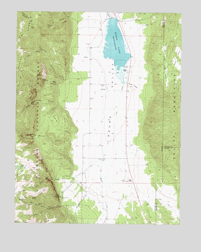
Scipio Lake, UT USGS Topographic Map
Click on map above to begin viewing in our Map Viewer.

This topographic map contains these locations and features:
Feature Name Type Latitude Longitude GNIS ID View Map
Cedar SpringSpringN39.0149°W112.1097°1439592View Map
Cutler CanyonValleyN39.1205°W112.0813°1440212View Map
Dairy KnollSummitN39.0905°W112.0410°1440234View Map
David Norris Spring (not official)SpringN39.0555°W112.0594°1455852View Map
Dry CanyonValleyN39.0261°W112.0960°1440565View Map
Hans Pumpernickle CanyonValleyN39.0719°W112.0897°1441577View Map
Ivie CreekStreamN39.0827°W112.0441°1442074View Map
Left Fork Rock CanyonValleyN39.0089°W112.1016°1442523View Map
Libbs CanyonValleyN39.0808°W112.0927°1442575View Map
Libbs SpringSpringN39.0828°W112.0981°1442576View Map
Little Long ValleyBasinN39.0938°W112.0122°1442735View Map
Loafers CanyonValleyN39.0861°W112.0860°1442828View Map
Maple GrovePopulated PlaceN39.0150°W112.0930°1443165View Map
Maple Grove CampgroundLocaleN39.0152°W112.0897°1451296View Map
Pharo CanyonValleyN39.0305°W112.0733°1451327View Map
Pharo CreekStreamN39.0305°W112.0733°1444325View Map
Pharo RidgeRidgeN39.0005°W112.1102°1444326View Map
Red KnollSummitN39.0252°W112.0397°1444805View Map
Robins LakeLakeN39.0326°W112.1218°1445022View Map
Rock CanyonValleyN39.0105°W112.0860°1445035View Map
Round HillSummitN39.0639°W112.0966°1445162View Map
Scipio LakeLakeN39.1037°W112.0513°1445377View Map
Scipio LakeReservoirN39.1216°W112.0541°1447764View Map
Scipio Lake DamDamN39.1216°W112.0541°1447765View Map
Spring Branch CanyonValleyN39.0497°W112.0827°1445977View Map
Three KnollsSummitN39.0813°W112.0377°1446568View Map
Willow CreekStreamN39.0386°W112.0585°1447409View Map

Note: Coordinates in the location and feature list above are referenced to NAD83 datum.


Copyright (C) 2008-2024 Ryan Niemi / Sunset Dynamics ... All Rights Reserved