TopoQuest Logo
Do you find TopoQuest useful?
Help keep TopoQuest running and adding new maps/features by donating!
Bitcoin:  19c7KJd3qBynnjoSw5npx9KScwjBe4ifkT
Litecoin:  LXs6TkuXGGXo1vDsWCkWVdjQX94eUKd6ui
Home View Maps Find Maps Find Places Resources & Links


Mount Hermon, Virginia Topographic Map

USGS Map Title: Mount Hermon, VA
USGS Map MRC: 36079F4
DRG (GeoTIFF) Download: o36079f4.tif


Neighboring USGS Topographic Map Quads:


  Callands, VA  
36079G5
 

  Chatham, VA  
36079G4
 

  Spring Garden, VA  
36079G3
 

  Whitmell, VA  
36079F5
 

  Mount Hermon, VA  
36079F4
 

  Blairs, VA  
36079F3
 

  Brosville, VA  
36079E5
 

  Danville, VA  
36079E4
 

  Ringgold, VA  
36079E3


Map MRC Location:

N37°
W80°
N37°
W79°
H8 H7 H6 H5 H4 H3 H2 H1
G8 G7 G6 G5 G4 G3 G2 G1
F8 F7 F6 F5 F4 F3 F2 F1
E8 E7 E6 E5 E4 E3 E2 E1
D8 D7 D6 D5 D4 D3 D2 D1
C8 C7 C6 C5 C4 C3 C2 C1
B8 B7 B6 B5 B4 B3 B2 B1
A8 A7 A6 A5 A4 A3 A2 A1
N36°
W80°
N36°
W79°

Mount Hermon, VA USGS 1:24K Topographic Map Preview:
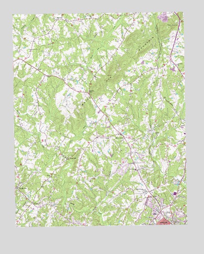
Mount Hermon, VA USGS Topographic Map
Click on map above to begin viewing in our Map Viewer.

This topographic map contains these locations and features:
Feature Name Type Latitude Longitude GNIS ID View Map
Afton HillsPopulated PlaceN36.6412°W79.3970°1738428View Map
Beverly ParkPopulated PlaceN36.6390°W79.3986°1738431View Map
Blairs Census Designated PlaceCensusN36.6959°W79.3774°2628830View Map
CartersvillePopulated PlaceN36.7276°W79.3839°1738556View Map
Chatham HillsPopulated PlaceN36.6265°W79.3936°1738438View Map
Chatham-Blairs DistrictCivilN36.7276°W79.4212°1927143View Map
Church of TruthChurchN36.7293°W79.4872°1464912View Map
Danville City Regional Alternative SchoolSchoolN36.6450°W79.4017°2498614View Map
Davis School (historical)SchoolN36.6515°W79.4453°1738559View Map
Deer Wood Springs DamDamN36.7151°W79.3831°1490572View Map
Deer Wood Springs LakeReservoirN36.7163°W79.3836°1490573View Map
Dry ForkStreamN36.6654°W79.4628°1465991View Map
Dry Fork ChurchChurchN36.7474°W79.4425°1465997View Map
Dry Fork Volunteer Fire DepartmentBuildingN36.7469°W79.4634°2075270View Map
Edwards BranchStreamN36.6487°W79.3764°1466185View Map
Fairfield ParkPopulated PlaceN36.6607°W79.4172°1738321View Map
Farthing DamDamN36.7201°W79.4047°1490597View Map
Fleemon ChurchChurchN36.6549°W79.4739°1466676View Map
Fleemon School (historical)SchoolN36.6551°W79.4736°1738563View Map
Gilfield ChurchChurchN36.7137°W79.4756°1467085View Map
Herndon School (historical)SchoolN36.7007°W79.4822°1738565View Map
Highland Burial ParkCemeteryN36.6332°W79.3889°1478753View Map
HopewellPopulated PlaceN36.7468°W79.4639°1495713View Map
Hughes Memorial SchoolSchoolN36.6449°W79.4047°1468359View Map
Johnsons Shop (historical)LocaleN36.7362°W79.4928°1738566View Map
Laniers MillPopulated PlaceN36.6651°W79.4603°1495819View Map
Little Sandy CreekStreamN36.6315°W79.4375°1469645View Map
Lumpkin ForestPopulated PlaceN36.6579°W79.3784°1738334View Map
Major CourtPopulated PlaceN36.6293°W79.3956°1738487View Map
Mount CrossPopulated PlaceN36.6390°W79.4878°1477557View Map
Mount Cross School (historical)SchoolN36.6371°W79.4734°1738570View Map
Mount Cross Volunteer Fire DepartmentBuildingN36.6381°W79.4788°2075239View Map
Mount HermonPopulated PlaceN36.6785°W79.4222°1477559View Map
Mount Hermon Census Designated PlaceCensusN36.6717°W79.4196°2629812View Map
Mount Hermon ChurchChurchN36.6615°W79.4128°1470884View Map
Mount Hermon Elementary SchoolSchoolN36.6576°W79.4120°1470891View Map
Mount Hermon School (historical)SchoolN36.6737°W79.4172°1738571View Map
Mount Hermon Volunteer Fire DepartmentBuildingN36.6777°W79.4203°2075240View Map
Mount Pleasant ChurchChurchN36.7187°W79.3803°1471030View Map
New DesignPopulated PlaceN36.6337°W79.3975°1495998View Map
New Mount CrossPopulated PlaceN36.6479°W79.4986°1471477View Map
Nor-Dan Church of ChristChurchN36.6274°W79.3959°1738492View Map
Nor-Dan Shopping CenterLocaleN36.6265°W79.3992°1738493View Map
North Main ChurchChurchN36.6254°W79.3847°1479216View Map
Northbrook ParkPopulated PlaceN36.6379°W79.3931°1738495View Map
Northview Presbyterian ChurchChurchN36.6301°W79.3936°1738496View Map
Norwood ParkPopulated PlaceN36.6254°W79.3814°1738497View Map
Oak Grove ChurchChurchN36.6740°W79.3770°1471703View Map
Olde Hunting HillsPopulated PlaceN36.6282°W79.4492°1738340View Map
Pleasant GapPopulated PlaceN36.7029°W79.4453°1496094View Map
RidgecrestPopulated PlaceN36.6662°W79.4095°1738345View Map
RobinwoodPopulated PlaceN36.6362°W79.4011°1738505View Map
Seminole HillsPopulated PlaceN36.6299°W79.3789°1738513View Map
Shadowwood ParkPopulated PlaceN36.6396°W79.4022°1738514View Map
Swain AcresPopulated PlaceN36.6276°W79.3814°1738524View Map
The Market Square Shopping CenterLocaleN36.6382°W79.3861°1738362View Map
Tuscarora Country ClubLocaleN36.6762°W79.4314°1491282View Map
Tuscarora Country Club DamDamN36.6685°W79.4364°1490576View Map
Tuscarora Country Club LakeReservoirN36.6683°W79.4386°1490577View Map
Twin Springs Elementary SchoolSchoolN36.6876°W79.4280°2498592View Map
Virginia HillsPopulated PlaceN36.6293°W79.4017°1738532View Map
WAKG-FM (Danville)TowerN36.7412°W79.3845°1498981View Map
White Oak MountainSummitN36.7135°W79.4278°1496404View Map
Whiteoak (historical)Populated PlaceN36.7168°W79.3947°1738579View Map
Whiteoak School (historical)SchoolN36.7237°W79.4142°1738580View Map
WittPopulated PlaceN36.6807°W79.3997°1477893View Map
WNDT-AM (Danville)TowerN36.6265°W79.4628°1498932View Map
Woodlake ParkPopulated PlaceN36.6496°W79.3831°1738376View Map
WXZF-TV (Danville)TowerN36.7429°W79.3856°1499014View Map

Note: Coordinates in the location and feature list above are referenced to NAD83 datum.


Copyright (C) 2008-2024 Ryan Niemi / Sunset Dynamics ... All Rights Reserved