TopoQuest Logo
Do you find TopoQuest useful?
Help keep TopoQuest running and adding new maps/features by donating!
Bitcoin:  19c7KJd3qBynnjoSw5npx9KScwjBe4ifkT
Litecoin:  LXs6TkuXGGXo1vDsWCkWVdjQX94eUKd6ui
Home View Maps Find Maps Find Places Resources & Links


Brosville, Virginia Topographic Map

USGS Map Title: Brosville, VA
USGS Map MRC: 36079E5
DRG (GeoTIFF) Download: o36079e5.tif


Neighboring USGS Topographic Map Quads:


  Axton, VA  
36079F6
 

  Whitmell, VA  
36079F5
 

  Mount Hermon, VA  
36079F4
 

  Northeast Eden, NC  
36079E6
 

  Brosville, VA  
36079E5
 

  Danville, VA  
36079E4
 

  Southeast Eden, NC  
36079D6
 

  Ruffin, NC  
36079D5
 

  Park Spring, NC  
36079D4


Map MRC Location:

N37°
W80°
N37°
W79°
H8 H7 H6 H5 H4 H3 H2 H1
G8 G7 G6 G5 G4 G3 G2 G1
F8 F7 F6 F5 F4 F3 F2 F1
E8 E7 E6 E5 E4 E3 E2 E1
D8 D7 D6 D5 D4 D3 D2 D1
C8 C7 C6 C5 C4 C3 C2 C1
B8 B7 B6 B5 B4 B3 B2 B1
A8 A7 A6 A5 A4 A3 A2 A1
N36°
W80°
N36°
W79°

Brosville, VA USGS 1:24K Topographic Map Preview:
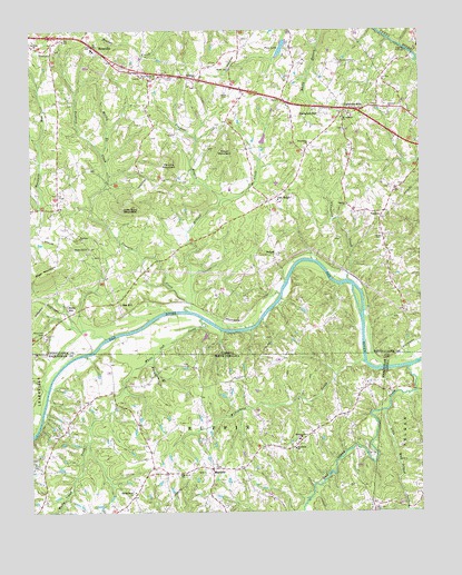
Brosville, VA USGS Topographic Map
Click on map above to begin viewing in our Map Viewer.

This topographic map contains these locations and features:
Feature Name Type Latitude Longitude GNIS ID View Map
Bachelors HallPopulated PlaceN36.6032°W79.5311°1498449View Map
Bachelors Hall Volunteer Fire DepartmentBuildingN36.5937°W79.5369°2075262View Map
Berry HillPopulated PlaceN36.5532°W79.6131°1498451View Map
Berry Hill CemeteryCemeteryN36.5457°W79.6209°1498452View Map
Bethel School (historical)SchoolN36.5551°W79.5392°1738304View Map
Bluestone Baptist ChurchChurchN36.5165°W79.5403°981640View Map
Boyd MountainSummitN36.5624°W79.6200°1498455View Map
Briarfield (historical)Populated PlaceN36.5501°W79.5625°1738306View Map
BrosvillePopulated PlaceN36.6196°W79.6020°1498457View Map
Brosville Community Volunteer Fire DepartmentBuildingN36.6202°W79.6023°2075264View Map
Brosville Elementary SchoolSchoolN36.6202°W79.6046°1738307View Map
Buckhorn BranchStreamN36.5407°W79.5856°982137View Map
BufordPopulated PlaceN36.5668°W79.5461°1498459View Map
Callahans HillsPopulated PlaceN36.6043°W79.5186°1498461View Map
Childress CreekStreamN36.5604°W79.5231°1498466View Map
Dan River Primitive Baptist ChurchChurchN36.5099°W79.5770°983930View Map
Deep River School (historical)SchoolN36.5121°W79.5856°1953279View Map
Dicks School (historical)SchoolN36.5415°W79.5725°1738317View Map
Harmony ChurchChurchN36.5712°W79.6089°1498488View Map
Hickory Forest CreekStreamN36.6204°W79.5053°1498491View Map
Hickory GrovePopulated PlaceN36.5187°W79.5384°1953317View Map
Hickory Grove United Methodist ChurchChurchN36.5190°W79.5389°986710View Map
Hillcrest ChurchChurchN36.6043°W79.5095°1498492View Map
Judy Byrd MountainSummitN36.5793°W79.5925°1498498View Map
Little Wolf Island CreekStreamN36.5262°W79.5114°988803View Map
MayfieldPopulated PlaceN36.5112°W79.5667°1021373View Map
McGuff CreekStreamN36.5543°W79.5728°1498516View Map
Moore DamDamN36.5968°W79.5498°1498865View Map
Moss CemeteryCemeteryN36.5712°W79.5120°1498519View Map
Motley BranchStreamN36.5932°W79.6014°1498520View Map
Mount Lebanon ChurchChurchN36.6024°W79.5242°1498521View Map
Oak HillPopulated PlaceN36.5546°W79.5967°1502085View Map
Oak Hill Station (historical)LocaleN36.5549°W79.5970°1738337View Map
Oak RidgePopulated PlaceN36.5815°W79.5459°1498524View Map
Perkins MountainSummitN36.5910°W79.5795°1498528View Map
Pine DamDamN36.6221°W79.5423°1498864View Map
Pine LakeReservoirN36.6204°W79.5440°1502094View Map
Piney Grove ChurchChurchN36.6126°W79.5881°1498530View Map
Piney Grove School (historical)SchoolN36.6129°W79.5884°1738341View Map
Powell (historical)Populated PlaceN36.5493°W79.5034°1738343View Map
Providence ChurchChurchN36.5951°W79.5350°1498532View Map
Pumphouse BranchStreamN36.5007°W79.5045°992897View Map
Saint Matthews School (historical)SchoolN36.5924°W79.5734°1738350View Map
Scearce Gammon CemeteryCemeteryN36.6157°W79.5236°1498535View Map
Soyar CemeteryCemeteryN36.6082°W79.5625°1498538View Map
Soyar MountainSummitN36.5929°W79.5609°1498539View Map
Spring Grove Presbyterian ChurchChurchN36.5054°W79.5917°995340View Map
Tardy BranchStreamN36.5310°W79.5020°995862View Map
The Lone ChurchChurchN36.6207°W79.6234°1498544View Map
Trayner BranchStreamN36.5810°W79.5631°1498545View Map
Trotters CreekStreamN36.5524°W79.5745°1498546View Map
VandolaPopulated PlaceN36.5779°W79.5114°1498547View Map
Vandola ChurchChurchN36.5796°W79.5231°1498548View Map
Vandola Church (historical)ChurchN36.5774°W79.5122°1738367View Map
Vandola School (historical)SchoolN36.5740°W79.5128°1738368View Map
Welcome ChurchChurchN36.6126°W79.5703°1498549View Map
Wenonda School (historical)SchoolN36.5804°W79.5500°1738371View Map
Westover DistrictCivilN36.5756°W79.5598°1927564View Map
White Oak CreekStreamN36.5504°W79.5698°997175View Map
Williamson CreekStreamN36.5390°W79.5178°997403View Map
Wolf Island CreekStreamN36.5376°W79.5034°997531View Map

Note: Coordinates in the location and feature list above are referenced to NAD83 datum.


Copyright (C) 2008-2024 Ryan Niemi / Sunset Dynamics ... All Rights Reserved