TopoQuest Logo
Do you find TopoQuest useful?
Help keep TopoQuest running and adding new maps/features by donating!
Bitcoin:  19c7KJd3qBynnjoSw5npx9KScwjBe4ifkT
Litecoin:  LXs6TkuXGGXo1vDsWCkWVdjQX94eUKd6ui
Home View Maps Find Maps Find Places Resources & Links


Chittenden, California Topographic Map

USGS Map Title: Chittenden, CA
USGS Map MRC: 36121H5
DRG (GeoTIFF) Download: o36121h5.tif


Neighboring USGS Topographic Map Quads:


  Mount Madonna, CA  
37121A6
 

  Gilroy, CA  
37121A5
 

  Gilroy Hot Springs, CA  
37121A4
 

  Watsonville East, CA  
36121H6
 

  Chittenden, CA  
36121H5
 

  San Felipe, CA  
36121H4
 

  Prunedale, CA  
36121G6
 

  San Juan Bautista, CA  
36121G5
 

  Hollister, CA  
36121G4


Map MRC Location:

N37°
W122°
N37°
W121°
H8 H7 H6 H5 H4 H3 H2 H1
G8 G7 G6 G5 G4 G3 G2 G1
F8 F7 F6 F5 F4 F3 F2 F1
E8 E7 E6 E5 E4 E3 E2 E1
D8 D7 D6 D5 D4 D3 D2 D1
C8 C7 C6 C5 C4 C3 C2 C1
B8 B7 B6 B5 B4 B3 B2 B1
A8 A7 A6 A5 A4 A3 A2 A1
N36°
W122°
N36°
W121°

Chittenden, CA USGS 1:24K Topographic Map Preview:
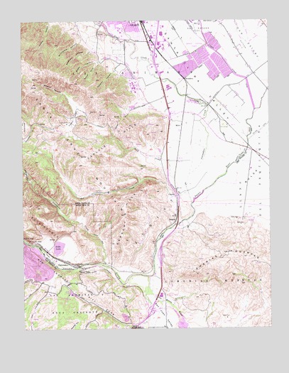
Chittenden, CA USGS Topographic Map
Click on map above to begin viewing in our Map Viewer.

This topographic map contains these locations and features:
Feature Name Type Latitude Longitude GNIS ID View Map
Anzar High SchoolSchoolN36.8812°W121.5560°2518103View Map
Anzar LakeLakeN36.8894°W121.6013°218315View Map
Babbs CanyonValleyN36.9852°W121.5827°218489View Map
Betabel (historical)Populated PlaceN36.8975°W121.5633°1670491View Map
Carlyle HillsAreaN36.9550°W121.5758°220604View Map
CarnaderoPopulated PlaceN36.9763°W121.5433°1655870View Map
Carnadero CreekStreamN36.9255°W121.5402°254714View Map
Carnadero School (historical)SchoolN36.9480°W121.5547°1670492View Map
Castro ValleyValleyN36.9538°W121.6036°220712View Map
ChittendenPopulated PlaceN36.9013°W121.6052°251973View Map
Christmas HillSummitN36.9888°W121.5861°1655895View Map
CorporalPopulated PlaceN36.9297°W121.5480°1655925View Map
Dexter CreekStreamN36.9913°W121.5122°253878View Map
El Pajaro SpringsSpringN36.9112°W121.6127°1873138View Map
Exit 347CrossingN36.8822°W121.5617°2124680View Map
Exit 349CrossingN36.9047°W121.5564°2124681View Map
Exit 353CrossingN36.9611°W121.5511°2123285View Map
Exit 355CrossingN36.9864°W121.5583°2123286View Map
Farman CanyonValleyN36.9813°W121.5769°223399View Map
Fep (historical)Populated PlaceN36.9466°W121.5086°1670477View Map
Gavilan College Golf CourseLocaleN36.9666°W121.5672°1835077View Map
Gavilan College LibraryBuildingN36.9747°W121.5699°1835078View Map
Gavilan College Main CampusSchoolN36.9724°W121.5686°224102View Map
Gavilan CreekStreamN36.9480°W121.5330°252146View Map
Gavilan Hills AcademySchoolN36.9988°W121.5260°2518298View Map
Gilroy Early College AcademySchoolN36.9739°W121.5681°2518195View Map
Gilroy High SchoolSchoolN36.9951°W121.5755°1835082View Map
Gilroy Wastewater Treatment PlantLocaleN36.9844°W121.5324°1835087View Map
Jones CreekStreamN36.9758°W121.5119°261998View Map
JuristaCivilN36.9172°W121.5572°226406View Map
Las AnimasCivilN36.9802°W121.5624°234135View Map
Las Animas Elementary SchoolSchoolN36.9899°W121.5805°1835149View Map
Llagas CreekStreamN36.9638°W121.5077°255106View Map
Lomerias MuertasCivilN36.8913°W121.5291°227501View Map
Lomerias MuertasSummitN36.9058°W121.5219°234184View Map
McCutchin CanyonValleyN36.9933°W121.5949°228340View Map
MillerPopulated PlaceN36.9572°W121.5447°1656167View Map
Miller SloughStreamN36.9908°W121.5319°228751View Map
Nema (historical)Populated PlaceN36.9611°W121.5511°1670493View Map
Old GilroyPopulated PlaceN36.9997°W121.5263°229969View Map
Pescadero CreekStreamN36.9011°W121.5855°230550View Map
Plantel (historical)Populated PlaceN36.9661°W121.5319°1670494View Map
Quarry LakeLakeN36.9074°W121.6249°231122View Map
Reservoir CanyonValleyN36.9886°W121.5894°231500View Map
River OaksPopulated PlaceN36.8997°W121.5944°1656258View Map
San Benito RiverStreamN36.8963°W121.5627°248799View Map
San YsidroCivilN36.9949°W121.5024°234644View Map
San Ysidro CreekStreamN36.9922°W121.5108°253896View Map
SargentPopulated PlaceN36.9194°W121.5480°1656278View Map
Sargent CreekStreamN36.8972°W121.5705°253827View Map
Sargent HillsAreaN36.9208°W121.5744°232585View Map
Sargent Oil FieldOilfieldN36.9302°W121.5874°232586View Map
Sawyers Crossing (historical)Populated PlaceN36.9572°W121.5216°1670497View Map
Soda LakeLakeN36.9087°W121.6075°234835View Map
Soda Lake 636 DamDamN36.9066°W121.6077°1664410View Map
South Fork Babbs CanyonValleyN36.9833°W121.5858°234964View Map
Star CreekStreamN36.9383°W121.6238°235390View Map
Sunnybrook School (historical)SchoolN36.9666°W121.5349°1670499View Map
Tar CreekStreamN36.9300°W121.5416°236025View Map
Tick CreekStreamN36.9327°W121.5430°236340View Map
Uvas CreekStreamN36.9719°W121.5466°236944View Map
Wildcat CanyonValleyN36.9708°W121.6047°237774View Map
Z - Best Composting FacilityLocaleN36.9478°W121.5242°2702591View Map

Note: Coordinates in the location and feature list above are referenced to NAD83 datum.


Copyright (C) 2008-2025 Ryan Niemi / Sunset Dynamics ... All Rights Reserved