TopoQuest Logo
Do you find TopoQuest useful?
Help keep TopoQuest running and adding new maps/features by donating!
Bitcoin:  19c7KJd3qBynnjoSw5npx9KScwjBe4ifkT
Litecoin:  LXs6TkuXGGXo1vDsWCkWVdjQX94eUKd6ui
Home View Maps Find Maps Find Places Resources & Links


Mount Thompson, Montana Topographic Map

USGS Map Title: Mount Thompson, MT
USGS Map MRC: 46112C2
DRG (GeoTIFF) Download: o46112c2.tif


Neighboring USGS Topographic Map Quads:


  Three Brothers, MT  
46112D3
 

  Chessman Reservoir, MT  
46112D2
 

  Jefferson City, MT  
46112D1
 

  Basin, MT  
46112C3
 

  Mount Thompson, MT  
46112C2
 

  Wickes, MT  
46112C1
 

  Bison Canyon, MT  
46112B3
 

  Boulder West, MT  
46112B2
 

  Boulder East, MT  
46112B1


Map MRC Location:

N47°
W113°
N47°
W112°
H8 H7 H6 H5 H4 H3 H2 H1
G8 G7 G6 G5 G4 G3 G2 G1
F8 F7 F6 F5 F4 F3 F2 F1
E8 E7 E6 E5 E4 E3 E2 E1
D8 D7 D6 D5 D4 D3 D2 D1
C8 C7 C6 C5 C4 C3 C2 C1
B8 B7 B6 B5 B4 B3 B2 B1
A8 A7 A6 A5 A4 A3 A2 A1
N46°
W113°
N46°
W112°

Mount Thompson, MT USGS 1:24K Topographic Map Preview:
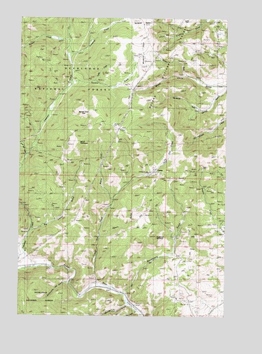
Mount Thompson, MT USGS Topographic Map
Click on map above to begin viewing in our Map Viewer.

This topographic map contains these locations and features:
Feature Name Type Latitude Longitude GNIS ID View Map
07N04W08DBDA01 WellWellN46.3708°W112.1272°815811View Map
Australian MineMineN46.3119°W112.1389°779198View Map
Ba Ka Maa MineMineN46.3744°W112.1856°803354View Map
Baltimore MineMineN46.2860°W112.1539°803274View Map
Big Limber GulchValleyN46.2858°W112.2411°779836View Map
Bishop CreekStreamN46.2988°W112.1933°779940View Map
Bluebird FlatsFlatN46.3583°W112.1758°780171View Map
Bluebird MineMineN46.3585°W112.1669°780172View Map
Bluebird MineMineN46.3583°W112.1675°803218View Map
Bluestone MineMineN46.3513°W112.1508°803469View Map
Boomerang (historical)LocaleN46.2597°W112.1869°1762512View Map
Boomerang GulchValleyN46.2608°W112.1856°780226View Map
Boston MineMineN46.2974°W112.2331°803340View Map
Boulder Chief MineMineN46.3302°W112.2108°780254View Map
Boulder Chief MineMineN46.3299°W112.2075°803347View Map
Boulder Chief ParkFlatN46.3366°W112.2131°780255View Map
Boulder Vestal MineMineN46.2916°W112.2397°803547View Map
Buckeye MineMineN46.2985°W112.2308°803342View Map
Buttermilk Jim GulchValleyN46.2641°W112.2211°780709View Map
California MineMineN46.2969°W112.2258°803341View Map
Cataract (historical)LocaleN46.2708°W112.2411°1762503View Map
Cataract CreekStreamN46.2705°W112.2408°781052View Map
Cataract MineMineN46.3374°W112.2328°803371View Map
Cataract Post Office (historical)Post OfficeN46.2708°W112.2411°1762501View Map
Clipper/Edna MineMineN46.3402°W112.2314°803370View Map
CometPopulated PlaceN46.3108°W112.1700°781541View Map
Comet Post Office (historical)Post OfficeN46.3108°W112.1700°1762579View Map
Comet TailingsMineN46.3033°W112.1689°803224View Map
Comet/Rumley MineMineN46.3116°W112.1661°803408View Map
Crawley Camp MineMineN46.3677°W112.1592°803243View Map
Curtain GulchValleyN46.3508°W112.1483°806156View Map
Custer/Hiawatha MineMineN46.3055°W112.2245°803357View Map
Deer Lodge MineMineN46.2974°W112.2306°803344View Map
Denver MineMineN46.2860°W112.1953°803397View Map
Eva May MineMineN46.3499°W112.2231°803290View Map
Eva May MineMineN46.3483°W112.2197°783251View Map
Free Enterprise MineMineN46.2552°W112.1478°783713View Map
FullerPopulated PlaceN46.2619°W112.2036°783783View Map
Galena GulchValleyN46.2544°W112.1839°783801View Map
Galena MineMineN46.3124°W112.1883°803401View Map
Glenbeg (historical)Populated PlaceN46.3694°W112.1481°799034View Map
Glenbeg Post Office (historical)Post OfficeN46.3694°W112.1481°1762572View Map
Gray Eagle MineMineN46.3133°W112.1997°784237View Map
Grey Eagle MineMineN46.3144°W112.2008°803244View Map
Hattie Ferguson MineMineN46.3316°W112.2381°784622View Map
Hattie Ferguson MineMineN46.3263°W112.2470°803245View Map
Hawkeye MineMineN46.3069°W112.1995°803399View Map
Hiawatha MineMineN46.3069°W112.2175°803374View Map
High Ore CreekStreamN46.2635°W112.2039°784857View Map
High Ore Spur (historical)LocaleN46.2583°W112.2133°1762680View Map
Hoodoo CreekStreamN46.3477°W112.2189°784984View Map
Ida M MineMineN46.3324°W112.2133°803355View Map
Interchange 160CrossingN46.2624°W112.2036°1762613View Map
Little Galena GulchValleyN46.2519°W112.1792°786293View Map
Lizzie Osborne MineMineN46.3485°W112.2050°803368View Map
Locker FlatsFlatN46.3744°W112.1536°806155View Map
Luddy CreekStreamN46.3488°W112.2058°786710View Map
Mantle East MineMineN46.2905°W112.2400°803247View Map
Mantle MineMineN46.2913°W112.2420°786823View Map
McKenzie GulchValleyN46.3366°W112.1397°806157View Map
Middle Snowdrift Creek MineMineN46.3666°W112.2070°803367View Map
Mina MineMineN46.3649°W112.1394°787447View Map
Minah MineMineN46.3647°W112.1386°803319View Map
Mineapolis MineMineN46.3013°W112.2392°803346View Map
Morning Glory MineMineN46.3174°W112.2433°787692View Map
Morning Glory MineMineN46.3180°W112.2439°803292View Map
Mount ThompsonSummitN46.3230°W112.2158°792108View Map
Mount Thompson MineMineN46.3130°W112.2114°803345View Map
Mountain Chief MineMineN46.3158°W112.2278°803356View Map
NE NE Section 13 MineMineN46.3627°W112.1631°803468View Map
NE NE Section 15 MineMineN46.2797°W112.2036°803396View Map
NE NW Section 16MineN46.3658°W112.2356°803934View Map
NE NW Section 3 MineMineN46.3069°W112.2133°803376View Map
NE SE Section 15 MineMineN46.2708°W112.2064°803394View Map
NE SW Section 1 MineMineN46.2997°W112.1753°803405View Map
New Cottage MineMineN46.2963°W112.2320°803343View Map
NW SE Section 15 MineMineN46.2722°W112.2106°803393View Map
NW SW Section 36 MineMineN46.3133°W112.1772°803403View Map
Pen Yan MineMineN46.3577°W112.1761°803478View Map
Placer 2313 MineMineN46.2805°W112.2495°803377View Map
Red Rock (historical)LocaleN46.2583°W112.2147°1762655View Map
Redemption MineMineN46.3138°W112.2120°803375View Map
Rochester MineMineN46.2930°W112.1744°803406View Map
Rocker CreekStreamN46.3652°W112.2211°789716View Map
S B Junior MineMineN46.2991°W112.1944°803398View Map
Salvail MineMineN46.3499°W112.1433°803320View Map
SE SW Section 28 MineMineN46.3235°W112.2361°803365View Map
Self - Riser MineMineN46.3027°W112.2272°803358View Map
Silver King MineMineN46.3110°W112.1869°803400View Map
Snowdrift CreekStreamN46.3591°W112.2214°790788View Map
Stair MineMineN46.3124°W112.1842°803407View Map
Sugarloaf MountainSummitN46.2835°W112.1689°791631View Map
SW NE Section 15 MineMineN46.2735°W112.2120°803395View Map
SW NW Section 28 MineMineN46.3319°W112.2383°803372View Map
SW SW Section 1 MineMineN46.2949°W112.1808°803404View Map
Uncle Sam GulchValleyN46.3177°W112.2458°792586View Map
Vera Marie MineMineN46.3213°W112.2397°803353View Map
Washington MineMineN46.3608°W112.1381°803222View Map
Washington MinesMineN46.3599°W112.1358°792853View Map
West Mount Thompson MineMineN46.3249°W112.2236°803359View Map
Will Parkinson MineMineN46.3116°W112.1772°803402View Map
Wood Chute GulchValleyN46.3470°W112.1347°793478View Map

Note: Coordinates in the location and feature list above are referenced to NAD83 datum.


Copyright (C) 2008-2024 Ryan Niemi / Sunset Dynamics ... All Rights Reserved