TopoQuest Logo
Do you find TopoQuest useful?
Help keep TopoQuest running and adding new maps/features by donating!
Bitcoin:  19c7KJd3qBynnjoSw5npx9KScwjBe4ifkT
Litecoin:  LXs6TkuXGGXo1vDsWCkWVdjQX94eUKd6ui
Home View Maps Find Maps Find Places Resources & Links


Mount Union, Pennsylvania Topographic Map

USGS Map Title: Mount Union, PA
USGS Map MRC: 40077D8
DRG (GeoTIFF) Download: o40077d8.tif


Neighboring USGS Topographic Map Quads:


  Alexandria, PA  
40078E1
 

  Donation, PA  
40077E8
 

  Allensville, PA  
40077E7
 

  Huntingdon, PA  
40078D1
 

  Mount Union, PA  
40077D8
 

  Newton Hamilton, PA  
40077D7
 

  Cassville, PA  
40078C1
 

  Butler Knob, PA  
40077C8
 

  Aughwick, PA  
40077C7


Map MRC Location:

N41°
W78°
N41°
W77°
H8 H7 H6 H5 H4 H3 H2 H1
G8 G7 G6 G5 G4 G3 G2 G1
F8 F7 F6 F5 F4 F3 F2 F1
E8 E7 E6 E5 E4 E3 E2 E1
D8 D7 D6 D5 D4 D3 D2 D1
C8 C7 C6 C5 C4 C3 C2 C1
B8 B7 B6 B5 B4 B3 B2 B1
A8 A7 A6 A5 A4 A3 A2 A1
N40°
W78°
N40°
W77°

Mount Union, PA USGS 1:24K Topographic Map Preview:
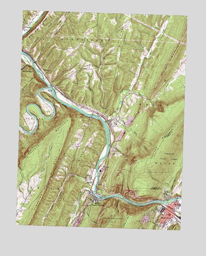
Mount Union, PA USGS Topographic Map
Click on map above to begin viewing in our Map Viewer.

This topographic map contains these locations and features:
Feature Name Type Latitude Longitude GNIS ID View Map
ArdenheimPopulated PlaceN40.4642°W77.9831°1168377View Map
Bark RidgeRidgeN40.4884°W77.9775°1168710View Map
BirdvillePopulated PlaceN40.4020°W77.9419°1169664View Map
Borough of MapletonCivilN40.3928°W77.9412°1215271View Map
Borough of Mill CreekCivilN40.4373°W77.9307°1215273View Map
Borough of Mount UnionCivilN40.3846°W77.8823°1215274View Map
Brown CemeteryCemeteryN40.4659°W77.8798°1958416View Map
Calvary ChurchChurchN40.4890°W77.9992°1170936View Map
Campbell Family CemeteryCemeteryN40.4948°W77.9317°2026391View Map
Cedar Crest Census Designated PlaceCensusN40.3966°W77.8857°2584443View Map
Cedar Crest ChurchChurchN40.3951°W77.8842°1171365View Map
Center School (historical)SchoolN40.4517°W77.9064°1197237View Map
Corbin BridgeBridgeN40.4547°W77.9831°2709855View Map
Corbin Family CemeteryCemeteryN40.4376°W77.9856°2026393View Map
Corbin SchoolSchoolN40.4395°W77.9814°1197238View Map
Dark Hollow DamDamN40.4034°W77.8864°1194788View Map
Deep Hollow RunStreamN40.3917°W77.9169°1173068View Map
Fields Farm CemeteryCemeteryN40.3878°W77.9042°2026394View Map
Flush RunStreamN40.4437°W77.9242°1174922View Map
FousetownPopulated PlaceN40.4517°W77.9178°1213069View Map
Furnace RunStreamN40.3931°W77.8806°1175360View Map
Goodman CemeteryCemeteryN40.4673°W77.9475°1175810View Map
Hampson Family CemeteryCemeteryN40.4098°W77.9405°2026375View Map
Hares ValleyValleyN40.3976°W77.9481°1176522View Map
Hares Valley CreekStreamN40.3959°W77.9403°1176523View Map
Hemphill HollowValleyN40.4753°W77.9949°1176819View Map
Henderson HollowValleyN40.4688°W77.9958°1176826View Map
Hill ValleyValleyN40.3815°W77.8789°1177085View Map
Huntingdon CountyCivilN40.4169°W77.9812°1213672View Map
Jacks NarrowsGapN40.3895°W77.9097°1177907View Map
Lick RidgeRidgeN40.4823°W77.9258°1179292View Map
Lone Star SchoolSchoolN40.4217°W77.9558°1197240View Map
Lucy FurnacePopulated PlaceN40.3934°W77.8858°1180067View Map
Lucy Furnace SchoolSchoolN40.3970°W77.8817°1197236View Map
Maley HollowValleyN40.4428°W77.9406°1180241View Map
MapletonPopulated PlaceN40.3937°W77.9411°1180374View Map
Mapleton Depot Post OfficePost OfficeN40.3919°W77.9386°2772818View Map
Mapleton Independent Order of Odd Fellows CemeteryCemeteryN40.4034°W77.9459°1182990View Map
Mapleton SchoolSchoolN40.4040°W77.9428°1180375View Map
Mapleton United Brethren Church CemeteryCemeteryN40.3957°W77.9440°1813192View Map
Mapleton Volunteer Fire Company Station 2BuildingN40.3928°W77.9412°2645534View Map
Mapleton-Union Elementary SchoolSchoolN40.4042°W77.9436°1211481View Map
Mill CreekStreamN40.4367°W77.9342°1181139View Map
Mill CreekPopulated PlaceN40.4356°W77.9308°1681784View Map
Mill Creek Borough Volunteer Fire Company 20BuildingN40.4402°W77.9227°2645535View Map
Mill Creek Post OfficePost OfficeN40.4383°W77.9338°2773208View Map
Miller Family CemeteryCemeteryN40.3801°W77.9582°2026374View Map
Mosser CemeteryCemeteryN40.4400°W77.9794°1988407View Map
Mount UnionPopulated PlaceN40.3845°W77.8822°1181865View Map
Mount Union Area Junior Senior High SchoolSchoolN40.3917°W77.8758°1211785View Map
Mount Union CemeteryCemeteryN40.3785°W77.8861°1182989View Map
Mount Union Fire Company Station 7BuildingN40.3835°W77.8828°2645324View Map
Mount Union Post OfficePost OfficeN40.3840°W77.8851°2772853View Map
Mountain Hide-Away AirportAirportN40.4364°W77.9003°2717079View Map
Mountainview CemeteryCemeteryN40.4348°W77.9294°1214726View Map
Numer HollowValleyN40.4702°W77.9889°1182714View Map
Old Mill Creek CemeteryCemeteryN40.4355°W77.9299°1813191View Map
Old White Church CemeteryCemeteryN40.4548°W77.9169°1182953View Map
Pennsylvania Fish Commission Access AreaAreaN40.4512°W77.9756°1206544View Map
Pennsylvania Glass Sand Company StationLocaleN40.4098°W77.9339°1213030View Map
Pike RunStreamN40.4451°W77.9597°1183729View Map
Raystown Branch Juniata RiverStreamN40.4548°W77.9775°1193174View Map
Saddler CreekStreamN40.4504°W77.9236°1185709View Map
Scrub RunStreamN40.3940°W77.9389°1187183View Map
Shaughnessy RunStreamN40.4234°W77.9303°1187387View Map
Shaver CemeteryCemeteryN40.3834°W77.8758°2061749View Map
Sheridan SchoolSchoolN40.3817°W77.9989°1197833View Map
Smith RunStreamN40.3992°W77.9400°1187889View Map
Smith ValleyValleyN40.4003°W77.9430°1187896View Map
Smoke SchoolSchoolN40.4870°W77.8981°1197241View Map
Snyders RunStreamN40.4751°W77.9997°1200118View Map
Strong CemeteryCemeteryN40.4542°W77.9807°1988413View Map
Sugar Grove RunStreamN40.4387°W77.9378°1188937View Map
Sugar Grove SchoolSchoolN40.4740°W77.9378°1197239View Map
Township of BradyCivilN40.4706°W77.8843°1216502View Map
WHUN-AM (Huntingdon)TowerN40.4551°W77.9803°1200415View Map
WRLR-FM (Huntingdon)TowerN40.4865°W77.9928°1200232View Map

Note: Coordinates in the location and feature list above are referenced to NAD83 datum.


Copyright (C) 2008-2025 Ryan Niemi / Sunset Dynamics ... All Rights Reserved