TopoQuest Logo
Do you find TopoQuest useful?
Help keep TopoQuest running and adding new maps/features by donating!
Bitcoin:  19c7KJd3qBynnjoSw5npx9KScwjBe4ifkT
Litecoin:  LXs6TkuXGGXo1vDsWCkWVdjQX94eUKd6ui
Home View Maps Find Maps Find Places Resources & Links


Cassville, Pennsylvania Topographic Map

USGS Map Title: Cassville, PA
USGS Map MRC: 40078C1
DRG (GeoTIFF) Download: o40078c1.tif


Neighboring USGS Topographic Map Quads:


  Williamsburg, PA  
40078D2
 

  Huntingdon, PA  
40078D1
 

  Mount Union, PA  
40077D8
 

  Entriken, PA  
40078C2
 

  Cassville, PA  
40078C1
 

  Butler Knob, PA  
40077C8
 

  Saxton, PA  
40078B2
 

  Saltillo, PA  
40078B1
 

  Orbisonia, PA  
40077B8


Map MRC Location:

N41°
W79°
N41°
W78°
H8 H7 H6 H5 H4 H3 H2 H1
G8 G7 G6 G5 G4 G3 G2 G1
F8 F7 F6 F5 F4 F3 F2 F1
E8 E7 E6 E5 E4 E3 E2 E1
D8 D7 D6 D5 D4 D3 D2 D1
C8 C7 C6 C5 C4 C3 C2 C1
B8 B7 B6 B5 B4 B3 B2 B1
A8 A7 A6 A5 A4 A3 A2 A1
N40°
W79°
N40°
W78°

Cassville, PA USGS 1:24K Topographic Map Preview:
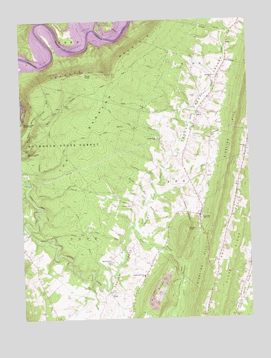
Cassville, PA USGS Topographic Map
Click on map above to begin viewing in our Map Viewer.

This topographic map contains these locations and features:
Feature Name Type Latitude Longitude GNIS ID View Map
Baker BridgeBridgeN40.2861°W78.1208°2709853View Map
BeavertownPopulated PlaceN40.2740°W78.0772°1203045View Map
Beavertown CemeteryCemeteryN40.2737°W78.0771°1813188View Map
Borough of CassvilleCivilN40.2928°W78.0272°1215267View Map
Bowman ChurchChurchN40.3212°W78.0011°1170063View Map
CalvinPopulated PlaceN40.3367°W78.0272°1170952View Map
Calvin Post OfficePost OfficeN40.3374°W78.0268°2779905View Map
CassvillePopulated PlaceN40.2931°W78.0269°1171314View Map
Cassville CemeteryCemeteryN40.2945°W78.0267°1813186View Map
Cassville Post OfficePost OfficeN40.2943°W78.0267°2779666View Map
Cherry GrovePopulated PlaceN40.2979°W78.0639°1203258View Map
ColfaxPopulated PlaceN40.3651°W78.0108°1203310View Map
Cornelius CemeteryCemeteryN40.2506°W78.0089°1172462View Map
Cornelius ChapelChurchN40.2501°W78.0100°1172463View Map
Curfman RunStreamN40.3079°W78.0522°1172840View Map
Eagle FoundaryLocaleN40.2526°W78.0861°1201257View Map
Horse KnobSummitN40.3531°W78.0883°1177442View Map
Laurel RunStreamN40.3223°W78.1247°1178980View Map
Lincoln Farms AirportAirportN40.3240°W78.0401°2442861View Map
Little Trough CreekStreamN40.2881°W78.0642°1179699View Map
Luciana BottomsBendN40.2659°W78.0372°1180059View Map
NewburgLocaleN40.2751°W78.1189°1207146View Map
Paradise Furnace CemeteryCemeteryN40.3140°W78.1239°2026380View Map
Point CampgroundLocaleN40.3717°W78.0806°1207585View Map
Raystown LakeReservoirN40.3639°W78.1023°1193175View Map
Salmon HoleLakeN40.3639°W78.1023°1202509View Map
Schrenkel AirportAirportN40.2627°W78.1011°2442969View Map
Sheridan ChurchChurchN40.3515°W78.0189°1187480View Map
Sheridan School CemeteryCemeteryN40.3513°W78.0191°1813183View Map
Shirley KnobSummitN40.2873°W78.0339°1187565View Map
Shores BranchStreamN40.3181°W78.0442°1187591View Map
Smith CemeteryCemeteryN40.3191°W78.0372°1813185View Map
Spring RunStreamN40.3323°W78.1153°1188256View Map
Stone CampLocaleN40.3406°W78.1000°1188705View Map
Sugar CreekStreamN40.2656°W78.0858°1188929View Map
Taylor CemeteryCemeteryN40.2533°W78.0663°1813189View Map
Terrace MountainSummitN40.3626°W78.0617°1193523View Map
The BarrensSummitN40.3292°W78.0864°1189387View Map
ToddPopulated PlaceN40.2601°W78.0764°1189617View Map
Todd CemeteryCemeteryN40.2612°W78.0778°1813187View Map
Todd TabernacleChurchN40.2631°W78.0883°1189619View Map
Township of CassCivilN40.2811°W78.0013°1216504View Map
Township of ToddCivilN40.2652°W78.1055°1216525View Map
Trough Creek Baptist CemeteryCemeteryN40.3259°W78.0504°1813184View Map
Trough Creek ChurchChurchN40.3256°W78.0492°1189823View Map
Trough Creek Valley SchoolSchoolN40.2679°W78.0583°1189825View Map
Trough Creek Volunteer Fire Company Station 21BuildingN40.2928°W78.0256°2645167View Map
Upper Comer Cemetery (historical)CemeteryN40.3695°W78.0956°1190229View Map
Upper CornersLocaleN40.3740°W78.0970°1207584View Map
Wilson RunStreamN40.2990°W78.0569°1191546View Map
Wright CemeteryCemeteryN40.3432°W78.0284°1191799View Map

Note: Coordinates in the location and feature list above are referenced to NAD83 datum.


Copyright (C) 2008-2025 Ryan Niemi / Sunset Dynamics ... All Rights Reserved