TopoQuest Logo
Do you find TopoQuest useful?
Help keep TopoQuest running and adding new maps/features by donating!
Bitcoin:  19c7KJd3qBynnjoSw5npx9KScwjBe4ifkT
Litecoin:  LXs6TkuXGGXo1vDsWCkWVdjQX94eUKd6ui
Home View Maps Find Maps Find Places Resources & Links


Newton Hamilton, Pennsylvania Topographic Map

USGS Map Title: Newton Hamilton, PA
USGS Map MRC: 40077D7
DRG (GeoTIFF) Download: o40077d7.tif


Neighboring USGS Topographic Map Quads:


  Donation, PA  
40077E8
 

  Allensville, PA  
40077E7
 

  Belleville, PA  
40077E6
 

  Mount Union, PA  
40077D8
 

  Newton Hamilton, PA  
40077D7
 

  McVeytown, PA  
40077D6
 

  Butler Knob, PA  
40077C8
 

  Aughwick, PA  
40077C7
 

  Blairs Mills, PA  
40077C6


Map MRC Location:

N41°
W78°
N41°
W77°
H8 H7 H6 H5 H4 H3 H2 H1
G8 G7 G6 G5 G4 G3 G2 G1
F8 F7 F6 F5 F4 F3 F2 F1
E8 E7 E6 E5 E4 E3 E2 E1
D8 D7 D6 D5 D4 D3 D2 D1
C8 C7 C6 C5 C4 C3 C2 C1
B8 B7 B6 B5 B4 B3 B2 B1
A8 A7 A6 A5 A4 A3 A2 A1
N40°
W78°
N40°
W77°

Newton Hamilton, PA USGS 1:24K Topographic Map Preview:
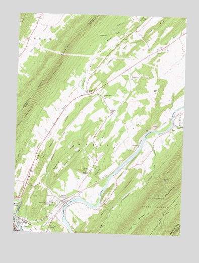
Newton Hamilton, PA USGS Topographic Map
Click on map above to begin viewing in our Map Viewer.

This topographic map contains these locations and features:
Feature Name Type Latitude Longitude GNIS ID View Map
AirydalePopulated PlaceN40.4845°W77.8675°1168101View Map
Atkinson MillsPopulated PlaceN40.4554°W77.8181°1202996View Map
Atkinson Mills Census Designated PlaceCensusN40.4519°W77.8052°2584435View Map
Atkinson Mills ChurchChurchN40.4531°W77.8094°1168485View Map
Beaverdam RunStreamN40.4048°W77.8053°1198035View Map
Borough of KistlerCivilN40.3770°W77.8654°1215456View Map
Borough of Newton HamiltonCivilN40.3925°W77.8355°1215459View Map
Brush Run SchoolSchoolN40.4104°W77.8181°1197231View Map
Brush Run Union ChurchChurchN40.4092°W77.8186°1170462View Map
Bunker HillSummitN40.4120°W77.8239°1170672View Map
Center SchoolSchoolN40.3959°W77.8453°1171450View Map
Center School (historical)SchoolN40.3995°W77.8492°1197230View Map
Fairview SchoolSchoolN40.4445°W77.8022°1174548View Map
Gearhart RidgeRidgeN40.4781°W77.7992°1175495View Map
Greenbrier RidgeRidgeN40.4204°W77.8356°1176135View Map
Hill Valley CreekStreamN40.3770°W77.8708°1177086View Map
Irvin HillSummitN40.4567°W77.7722°1177862View Map
Kansas RidgeRidgeN40.4881°W77.8033°1178219View Map
KistlerPopulated PlaceN40.3801°W77.8683°1178561View Map
Little KansasPopulated PlaceN40.4879°W77.8108°1204034View Map
Long HollowValleyN40.3936°W77.8714°1179853View Map
Long Hollow RidgeRidgeN40.4331°W77.8425°1179858View Map
Long Hollow RunStreamN40.3937°W77.8714°1212872View Map
Long Hollow School (historical)SchoolN40.4267°W77.8547°1197229View Map
Methodist Training CampLocaleN40.3923°W77.8461°1180978View Map
Musser RunStreamN40.4767°W77.7758°1182117View Map
Newton HamiltonPopulated PlaceN40.3917°W77.8369°1182414View Map
Newton Hamilton Post OfficePost OfficeN40.3919°W77.8374°2772878View Map
Newton Wayne Volunteer Fire Company Station 26BuildingN40.3927°W77.8394°2645820View Map
Orebank RidgeRidgeN40.4945°W77.7711°1183033View Map
Pine Grove SchoolSchoolN40.4917°W77.7872°1197233View Map
Ross Grove SchoolSchoolN40.4770°W77.7792°1197234View Map
RydePopulated PlaceN40.4356°W77.7589°1185667View Map
Sandy RidgeRidgeN40.4317°W77.7894°1186957View Map
Shanks RunStreamN40.4381°W77.7575°1187352View Map
Silver Ford HeightsPopulated PlaceN40.3773°W77.8483°1193363View Map
Sugar RidgeRidgeN40.4059°W77.7869°1188957View Map
Township of WayneCivilN40.4175°W77.8159°1216833View Map
Vance SchoolSchoolN40.4584°W77.7558°1197235View Map
VineyardPopulated PlaceN40.4248°W77.7836°1204877View Map
Wayne ChurchChurchN40.4645°W77.7883°1190712View Map
Wharton GapGapN40.4059°W77.7633°1191204View Map
Wharton RunStreamN40.4292°W77.7783°1191206View Map
Wharton SchoolSchoolN40.4242°W77.7714°1197232View Map

Note: Coordinates in the location and feature list above are referenced to NAD83 datum.


Copyright (C) 2008-2024 Ryan Niemi / Sunset Dynamics ... All Rights Reserved