TopoQuest Logo
Do you find TopoQuest useful?
Help keep TopoQuest running and adding new maps/features by donating!
Bitcoin:  19c7KJd3qBynnjoSw5npx9KScwjBe4ifkT
Litecoin:  LXs6TkuXGGXo1vDsWCkWVdjQX94eUKd6ui
Home View Maps Find Maps Find Places Resources & Links


Donation, Pennsylvania Topographic Map

USGS Map Title: Donation, PA
USGS Map MRC: 40077E8
DRG (GeoTIFF) Download: o40077e8.tif


Neighboring USGS Topographic Map Quads:


  Franklinville, PA  
40078F1
 

  Pine Grove Mills, PA  
40077F8
 

  McAlevys Fort, PA  
40077F7
 

  Alexandria, PA  
40078E1
 

  Donation, PA  
40077E8
 

  Allensville, PA  
40077E7
 

  Huntingdon, PA  
40078D1
 

  Mount Union, PA  
40077D8
 

  Newton Hamilton, PA  
40077D7


Map MRC Location:

N41°
W78°
N41°
W77°
H8 H7 H6 H5 H4 H3 H2 H1
G8 G7 G6 G5 G4 G3 G2 G1
F8 F7 F6 F5 F4 F3 F2 F1
E8 E7 E6 E5 E4 E3 E2 E1
D8 D7 D6 D5 D4 D3 D2 D1
C8 C7 C6 C5 C4 C3 C2 C1
B8 B7 B6 B5 B4 B3 B2 B1
A8 A7 A6 A5 A4 A3 A2 A1
N40°
W78°
N40°
W77°

Donation, PA USGS 1:24K Topographic Map Preview:
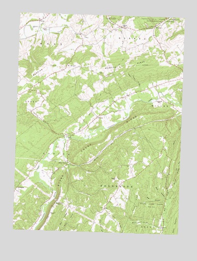
Donation, PA USGS Topographic Map
Click on map above to begin viewing in our Map Viewer.

This topographic map contains these locations and features:
Feature Name Type Latitude Longitude GNIS ID View Map
Agudath Achim Memorial ParkCemeteryN40.5158°W77.9684°1168091View Map
Back HollowValleyN40.5209°W77.8849°1168560View Map
Barkridge SchoolSchoolN40.5009°W77.9672°1196994View Map
Big HollowValleyN40.5185°W77.8859°1169518View Map
Center UnionPopulated PlaceN40.5384°W77.9608°1171462View Map
Chilcoat RunStreamN40.5537°W77.9619°1171776View Map
Cold SpringPopulated PlaceN40.5245°W77.9981°1172151View Map
Cold Spring SchoolSchoolN40.5251°W77.9975°1196993View Map
Cornpropst MillsLocaleN40.5784°W77.8911°1172470View Map
Cornpropst Mills Baptist CemeteryCemeteryN40.5768°W77.8893°1813176View Map
CottagePopulated PlaceN40.6209°W77.9844°1172484View Map
Coy CemeteryCemeteryN40.5789°W77.8785°1958423View Map
DonationPopulated PlaceN40.5667°W77.9378°1173366View Map
Donation CemeteryCemeteryN40.5664°W77.9393°1813178View Map
Drake RidgeRidgeN40.5206°W77.9050°1173449View Map
Evans Family CemeteryCemeteryN40.5472°W77.9079°2026392View Map
Ewing CemeteryCemeteryN40.6170°W77.9277°1847148View Map
Feltenberger Airport (historical)AirportN40.5473°W77.9658°1194021View Map
Garner RunStreamN40.6217°W77.9636°1175458View Map
Globe RunStreamN40.6165°W77.9839°1175754View Map
Gorsuch CemeteryCemeteryN40.5361°W77.9617°1958419View Map
Gregory RunStreamN40.6192°W77.9653°1176215View Map
Hilling International AirportAirportN40.5048°W77.9382°2442979View Map
Horn RunStreamN40.5531°W77.9531°1177416View Map
Huntingdon Regional Fire and Rescue Department 65 Station 18BuildingN40.5457°W77.9612°2644754View Map
Maddern RunStreamN40.5040°W77.8861°1180174View Map
Manor HillPopulated PlaceN40.6187°W77.9208°1180294View Map
Manor Hill Methodist CemeteryCemeteryN40.6195°W77.9183°1813175View Map
Manor Hill Presbyterian CemeteryCemeteryN40.6187°W77.9225°1813174View Map
Mateer CemeteryCemeteryN40.5594°W77.9199°2061750View Map
Mount Zion ChurchChurchN40.5142°W77.9314°1181923View Map
Mount Zion Lutheran Church CemeteryCemeteryN40.5141°W77.9316°1813177View Map
Murray RunStreamN40.5531°W77.9617°1182106View Map
Myton SchoolSchoolN40.6109°W77.9519°1196999View Map
Pennsylvania State University Experimental ForestSchoolN40.6242°W77.9289°1168015View Map
Pine HillSummitN40.5917°W77.9353°1183824View Map
Ramsey HollowValleyN40.5827°W77.9059°1184632View Map
Ramsey TrailTrailN40.5881°W77.9108°1184638View Map
Ridge School (historical)SchoolN40.6001°W77.8856°1196997View Map
Round TopSummitN40.5312°W77.9225°1185548View Map
SaulsburgPopulated PlaceN40.6206°W77.8947°1187008View Map
Smith SchoolSchoolN40.5851°W77.8947°1196998View Map
Standing Stone Golf CourseLocaleN40.5362°W77.9692°1206564View Map
State Game Lands Number 112ParkN40.5145°W77.8958°1188434View Map
Steel CemeteryCemeteryN40.5387°W77.9128°1188579View Map
Stewart Family CemeteryCemeteryN40.5406°W77.9544°2026395View Map
Stone Creek RidgeRidgeN40.5551°W77.9286°1193472View Map
Stone Creek Valley ParkParkN40.5545°W77.9603°1188717View Map
Swigart PondLakeN40.6159°W77.9780°1189188View Map
Township of HendersonCivilN40.5007°W77.9397°1216509View Map
Township of OneidaCivilN40.5453°W77.9690°1216516View Map
Union Church (historical)ChurchN40.5134°W77.9317°1196995View Map
Union SchoolSchoolN40.5195°W77.9194°1196996View Map
Warm SpringSpringN40.5478°W77.9739°1202306View Map
Warm SpringLocaleN40.5417°W77.9797°1207144View Map

Note: Coordinates in the location and feature list above are referenced to NAD83 datum.


Copyright (C) 2008-2025 Ryan Niemi / Sunset Dynamics ... All Rights Reserved