TopoQuest Logo
Do you find TopoQuest useful?
Help keep TopoQuest running and adding new maps/features by donating!
Bitcoin:  19c7KJd3qBynnjoSw5npx9KScwjBe4ifkT
Litecoin:  LXs6TkuXGGXo1vDsWCkWVdjQX94eUKd6ui
Home View Maps Find Maps Find Places Resources & Links


Brentwood, Arkansas Topographic Map

USGS Map Title: Brentwood, AR
USGS Map MRC: 35094G1
DRG (GeoTIFF) Download: o35094g1.tif


Neighboring USGS Topographic Map Quads:


  West Fork, AR  
35094H2
 

  Sulphur City, AR  
35094H1
 

  Durham, AR  
35093H8
 

  Winslow, AR  
35094G2
 

  Brentwood, AR  
35094G1
 

  Delaney, AR  
35093G8
 

  Mountainburg, AR  
35094F2
 

  Fern, AR  
35094F1
 

  Bidville, AR  
35093F8


Map MRC Location:

N36°
W95°
N36°
W94°
H8 H7 H6 H5 H4 H3 H2 H1
G8 G7 G6 G5 G4 G3 G2 G1
F8 F7 F6 F5 F4 F3 F2 F1
E8 E7 E6 E5 E4 E3 E2 E1
D8 D7 D6 D5 D4 D3 D2 D1
C8 C7 C6 C5 C4 C3 C2 C1
B8 B7 B6 B5 B4 B3 B2 B1
A8 A7 A6 A5 A4 A3 A2 A1
N35°
W95°
N35°
W94°

Brentwood, AR USGS 1:24K Topographic Map Preview:
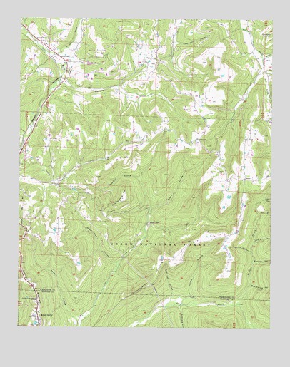
Brentwood, AR USGS Topographic Map
Click on map above to begin viewing in our Map Viewer.

This topographic map contains these locations and features:
Feature Name Type Latitude Longitude GNIS ID View Map
Arnett Church (historical)ChurchN35.8556°W94.0058°65275View Map
Barnard HollowValleyN35.7770°W94.0077°70514View Map
Bee BranchStreamN35.7965°W94.0052°70601View Map
Black Oak ChurchChurchN35.8356°W94.0344°70700View Map
BrentwoodPopulated PlaceN35.8601°W94.1071°81845View Map
Brown HollowValleyN35.7979°W94.0594°70842View Map
Dry CreekStreamN35.8592°W94.0049°71436View Map
Gabbard HollowValleyN35.7581°W94.0441°71705View Map
Gaylor MountainSummitN35.7651°W94.1171°71743View Map
Goat Den HollowValleyN35.7637°W94.0485°71768View Map
Henderson MountainSummitN35.7762°W94.0466°71963View Map
Hutchins CreekStreamN35.8501°W94.1055°72135View Map
Jones BranchStreamN35.8556°W94.1049°72209View Map
KAFT-TV (Fayetteville)TowerN35.8117°W94.0269°85438View Map
Keets HollowValleyN35.8020°W94.0033°72240View Map
KEZA-FM (Fayetteville)TowerN35.8534°W94.0260°85389View Map
Koyle CemeteryCemeteryN35.7895°W94.1060°72272View Map
KUAF-FM (Fayetteville)TowerN35.8534°W94.0260°85390View Map
Lafe Evans HollowValleyN35.7856°W94.0074°72277View Map
London CreekStreamN35.8623°W94.1144°72450View Map
Low GapLocaleN35.8265°W94.0371°72503View Map
Mast CreekStreamN35.8540°W94.0049°72566View Map
Millers ChapelChurchN35.7917°W94.0613°72682View Map
Mount GaylorPopulated PlaceN35.7531°W94.1152°72749View Map
Mount Gaylor LakeReservoirN35.7516°W94.1164°80148View Map
Mount Gaylor Lake DamDamN35.7501°W94.1169°80147View Map
Mount Gaylor Lookout TowerTowerN35.7509°W94.1149°82592View Map
Mud Spring HollowValleyN35.7667°W94.0091°72805View Map
Our Lady of the Ozarks ShrineChurchN35.7609°W94.1169°72962View Map
Parks CemeteryCemeteryN35.8259°W94.1105°73007View Map
Paschal HollowValleyN35.8104°W94.0663°73010View Map
Pense HollowValleyN35.7526°W94.0958°73043View Map
Porters Store (historical)Populated PlaceN35.8592°W94.0044°65412View Map
Purdue HollowValleyN35.7631°W94.0399°73215View Map
Rural District 8 Station 1BuildingN35.7529°W94.1153°2117072View Map
Shrader BranchStreamN35.7595°W94.0155°78361View Map
Skelton HollowValleyN35.7812°W94.0102°73597View Map
Sugar Tree HollowValleyN35.7759°W94.0774°73757View Map
SunsetPopulated PlaceN35.8104°W94.0133°78505View Map
Sunset Post Office (historical)Post OfficeN35.8106°W94.0174°84321View Map
Sunset Volunteer Fire DepartmentBuildingN35.8118°W94.0127°2117195View Map
Terry CemeteryCemeteryN35.7945°W94.0149°73843View Map
Tom Ritter HollowValleyN35.8656°W94.0480°73878View Map
Township of CrawfordCivilN35.8669°W94.0889°69784View Map
Township of WinslowCivilN35.7936°W94.1090°69811View Map
Weedy Rough MountainSummitN35.8012°W94.0752°74039View Map
Weedy Rough Mountain Lookout TowerTowerN35.8012°W94.0749°74431View Map

Note: Coordinates in the location and feature list above are referenced to NAD83 datum.


Copyright (C) 2008-2025 Ryan Niemi / Sunset Dynamics ... All Rights Reserved