TopoQuest Logo
Do you find TopoQuest useful?
Help keep TopoQuest running and adding new maps/features by donating!
Bitcoin:  19c7KJd3qBynnjoSw5npx9KScwjBe4ifkT
Litecoin:  LXs6TkuXGGXo1vDsWCkWVdjQX94eUKd6ui
Home View Maps Find Maps Find Places Resources & Links


Strickler, Arkansas Topographic Map

USGS Map Title: Strickler, AR
USGS Map MRC: 35094G3
DRG (GeoTIFF) Download: o35094g3.tif


Neighboring USGS Topographic Map Quads:


  Lincoln, AR  
35094H4
 

  Prairie Grove, AR  
35094H3
 

  West Fork, AR  
35094H2
 

  Evansville, AR  
35094G4
 

  Strickler, AR  
35094G3
 

  Winslow, AR  
35094G2
 

  Natural Dam, AR  
35094F4
 

  Rudy NE, AR  
35094F3
 

  Mountainburg, AR  
35094F2


Map MRC Location:

N36°
W95°
N36°
W94°
H8 H7 H6 H5 H4 H3 H2 H1
G8 G7 G6 G5 G4 G3 G2 G1
F8 F7 F6 F5 F4 F3 F2 F1
E8 E7 E6 E5 E4 E3 E2 E1
D8 D7 D6 D5 D4 D3 D2 D1
C8 C7 C6 C5 C4 C3 C2 C1
B8 B7 B6 B5 B4 B3 B2 B1
A8 A7 A6 A5 A4 A3 A2 A1
N35°
W95°
N35°
W94°

Strickler, AR USGS 1:24K Topographic Map Preview:
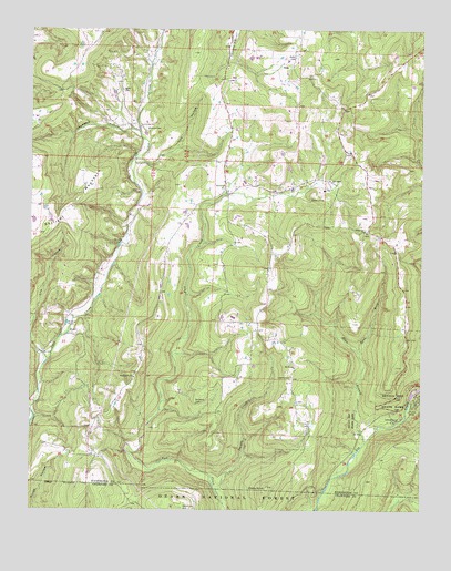
Strickler, AR USGS Topographic Map
Click on map above to begin viewing in our Map Viewer.

This topographic map contains these locations and features:
Feature Name Type Latitude Longitude GNIS ID View Map
Baker CemeteryCemeteryN35.8681°W94.2913°70490View Map
Bug Scuffle ChurchChurchN35.7845°W94.3419°70918View Map
Chambers HollowValleyN35.8484°W94.3408°71110View Map
Cherry KnobSummitN35.7559°W94.2991°71125View Map
Cove Creek ChurchChurchN35.8498°W94.3405°71249View Map
Devils Den Natural BridgeArchN35.7719°W94.2611°2571580View Map
Devils Den State ParkParkN35.7806°W94.2516°71376View Map
Dunkard CemeteryCemeteryN35.7776°W94.3219°71475View Map
East Fork Ellis BranchStreamN35.7912°W94.2697°71503View Map
Eighty Six ChurchChurchN35.7873°W94.2905°71543View Map
Ellis BranchStreamN35.7679°W94.2677°71552View Map
Fall Creek School (historical)SchoolN35.8334°W94.3127°65333View Map
FlossPopulated PlaceN35.7951°W94.3610°71642View Map
Garrett Hollow CreekStreamN35.7765°W94.3747°65356View Map
Liberty CemeteryCemeteryN35.7845°W94.2913°72325View Map
Lick HollowValleyN35.8409°W94.3402°72345View Map
Locust CreekStreamN35.7534°W94.3138°72434View Map
Morrow CemeteryCemeteryN35.8492°W94.3383°72736View Map
Oak Grove CemeteryCemeteryN35.7501°W94.3263°72910View Map
OndaPopulated PlaceN35.8665°W94.2919°72952View Map
Scott CemeteryCemeteryN35.8592°W94.3463°73500View Map
StricklerPopulated PlaceN35.8337°W94.3133°78474View Map
Strickler Post Office (historical)Post OfficeN35.8204°W94.3308°84318View Map
Strickler Volunteer Fire DepartmentBuildingN35.8317°W94.3118°2117177View Map
Township of Cove CreekCivilN35.8124°W94.3063°69783View Map
Wickwire School (historical)SchoolN35.7848°W94.3419°65494View Map
Zinnamon ChurchChurchN35.8229°W94.2685°74234View Map

Note: Coordinates in the location and feature list above are referenced to NAD83 datum.


Copyright (C) 2008-2024 Ryan Niemi / Sunset Dynamics ... All Rights Reserved