TopoQuest Logo
Do you find TopoQuest useful?
Help keep TopoQuest running and adding new maps/features by donating!
Bitcoin:  19c7KJd3qBynnjoSw5npx9KScwjBe4ifkT
Litecoin:  LXs6TkuXGGXo1vDsWCkWVdjQX94eUKd6ui
Home View Maps Find Maps Find Places Resources & Links


Mud Lake, Montana Topographic Map

USGS Map Title: Mud Lake, MT
USGS Map MRC: 45113F4
DRG (GeoTIFF) Download: o45113f4.tif


Neighboring USGS Topographic Map Quads:


  Mussigbrod Lake, MT  
45113G5
 

  Pintler Lake, MT  
45113G4
 

  Pine Hill, MT  
45113G3
 

  Gibbons School, MT  
45113F5
 

  Mud Lake, MT  
45113F4
 

  Proposal Rock, MT  
45113F3
 

  Highland Ranch, MT  
45113E5
 

  Wisdom, MT  
45113E4
 

  Stewart Mountain, MT  
45113E3


Map MRC Location:

N46°
W114°
N46°
W113°
H8 H7 H6 H5 H4 H3 H2 H1
G8 G7 G6 G5 G4 G3 G2 G1
F8 F7 F6 F5 F4 F3 F2 F1
E8 E7 E6 E5 E4 E3 E2 E1
D8 D7 D6 D5 D4 D3 D2 D1
C8 C7 C6 C5 C4 C3 C2 C1
B8 B7 B6 B5 B4 B3 B2 B1
A8 A7 A6 A5 A4 A3 A2 A1
N45°
W114°
N45°
W113°

Mud Lake, MT USGS 1:24K Topographic Map Preview:
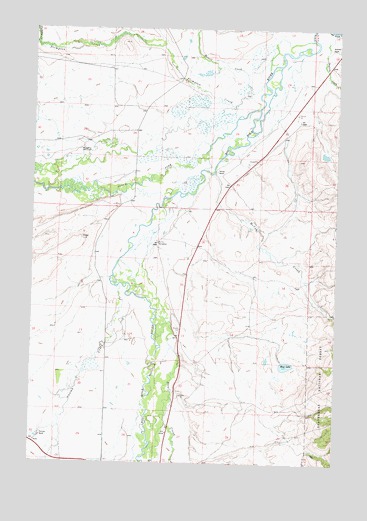
Mud Lake, MT USGS Topographic Map
Click on map above to begin viewing in our Map Viewer.

This topographic map contains these locations and features:
Feature Name Type Latitude Longitude GNIS ID View Map
01S15W35BCAB01 WellWellN45.7091°W113.4253°811324View Map
01S15W35BDCC01 WellWellN45.7063°W113.4220°811300View Map
02S15W15CABA01 WellWellN45.6616°W113.4414°810912View Map
02S15W28BADD01 WellWellN45.6369°W113.4609°810725View Map
02S15W28CDCC01 WellWellN45.6258°W113.4634°810653View Map
02S15W29CBDB01 WellWellN45.6305°W113.4873°810683View Map
02S15W29CCAB01 WellWellN45.6288°W113.4876°810665View Map
Daniels RanchLocaleN45.7091°W113.4251°782077View Map
Doolittle CreekStreamN45.7499°W113.3856°782481View Map
Graveyard (historical)LocaleN45.6874°W113.4328°1797347View Map
Howell CreekStreamN45.7471°W113.3870°785113View Map
McVey CreekStreamN45.7085°W113.4262°787122View Map
McVey HomesteadLocaleN45.6885°W113.4492°787123View Map
Mud LakeLakeN45.6533°W113.3958°787792View Map
Mud Lake DamDamN45.6533°W113.3959°798739View Map
Mussigbrod HomesteadLocaleN45.7158°W113.4806°787887View Map
North Fork Big Hole RiverStreamN45.7271°W113.4084°788097View Map
Plimpton CreekStreamN45.7352°W113.4064°789000View Map
Rutledge RanchLocaleN45.7444°W113.3781°789873View Map
Spokane RanchLocaleN45.6321°W113.4967°791170View Map
Steel CreekStreamN45.6719°W113.4531°791477View Map
Swamp CreekStreamN45.6758°W113.4651°791768View Map
Wisdom CemeteryCemeteryN45.6624°W113.4403°793433View Map

Note: Coordinates in the location and feature list above are referenced to NAD83 datum.


Copyright (C) 2008-2025 Ryan Niemi / Sunset Dynamics ... All Rights Reserved