TopoQuest Logo
Do you find TopoQuest useful?
Help keep TopoQuest running and adding new maps/features by donating!
Bitcoin:  19c7KJd3qBynnjoSw5npx9KScwjBe4ifkT
Litecoin:  LXs6TkuXGGXo1vDsWCkWVdjQX94eUKd6ui
Home View Maps Find Maps Find Places Resources & Links


Pintler Lake, Montana Topographic Map

USGS Map Title: Pintler Lake, MT
USGS Map MRC: 45113G4
DRG (GeoTIFF) Download: o45113g4.tif


Neighboring USGS Topographic Map Quads:


  Kelly Lake, MT  
45113H5
 

  Warren Peak, MT  
45113H4
 

  Long Peak, MT  
45113H3
 

  Mussigbrod Lake, MT  
45113G5
 

  Pintler Lake, MT  
45113G4
 

  Pine Hill, MT  
45113G3
 

  Gibbons School, MT  
45113F5
 

  Mud Lake, MT  
45113F4
 

  Proposal Rock, MT  
45113F3


Map MRC Location:

N46°
W114°
N46°
W113°
H8 H7 H6 H5 H4 H3 H2 H1
G8 G7 G6 G5 G4 G3 G2 G1
F8 F7 F6 F5 F4 F3 F2 F1
E8 E7 E6 E5 E4 E3 E2 E1
D8 D7 D6 D5 D4 D3 D2 D1
C8 C7 C6 C5 C4 C3 C2 C1
B8 B7 B6 B5 B4 B3 B2 B1
A8 A7 A6 A5 A4 A3 A2 A1
N45°
W114°
N45°
W113°

Pintler Lake, MT USGS 1:24K Topographic Map Preview:
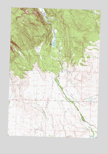
Pintler Lake, MT USGS Topographic Map
Click on map above to begin viewing in our Map Viewer.

This topographic map contains these locations and features:
Feature Name Type Latitude Longitude GNIS ID View Map
01N15W14BCAA01 WellWellN45.8388°W113.4367°812634View Map
01N15W34DADC01 WellWellN45.7724°W113.4431°811876View Map
01N15W34DDAB01 WellWellN45.7888°W113.4423°812045View Map
01N15W34DDAB02 WellWellN45.7883°W113.4428°812039View Map
01S15W02ADAC01 WellWellN45.7799°W113.4084°811951View Map
01S15W03BBCD01 WellWellN45.7819°W113.4459°811975View Map
01S15W03BCBA01 WellWellN45.7816°W113.4467°811971View Map
01S15W03BCBA02 WellWellN45.7810°W113.4464°811963View Map
01S15W04DACC01 WellWellN45.7749°W113.4531°811903View Map
01S15W08BADD01 WellWellN45.7677°W113.4806°811822View Map
Big Bushong DitchCanalN45.8146°W113.4192°779769View Map
Bowen Post Office (historical)Post OfficeN45.7583°W113.4592°1797106View Map
Bowen School (historical)SchoolN45.7858°W113.4273°780303View Map
Christensen RanchLocaleN45.7813°W113.4459°794847View Map
Christenson DitchCanalN45.7874°W113.4078°781252View Map
Dreise RanchLocaleN45.7852°W113.4942°794814View Map
East Fork Mudd CreekStreamN45.8710°W113.3834°782881View Map
East Fork Thompson CreekStreamN45.7871°W113.4981°782913View Map
L Bacon RanchLocaleN45.7894°W113.4420°794813View Map
Lion LakeLakeN45.8258°W113.4540°786199View Map
McCormick CreekStreamN45.7660°W113.4448°787013View Map
McCormick ParkFlatN45.8349°W113.4626°787016View Map
Nyhart DitchCanalN45.8046°W113.4145°788353View Map
Pintler CampgroundLocaleN45.8388°W113.4364°794812View Map
Pintler FallsFallsN45.8599°W113.4456°788923View Map
Pintler LakeLakeN45.8403°W113.4405°788924View Map
Pintler MeadowsFlatN45.8677°W113.4559°788925View Map
Roberts CreekStreamN45.8321°W113.4623°789630View Map
Sparrow Waste DitchCanalN45.7852°W113.4028°791137View Map
West Fork Mudd CreekStreamN45.8710°W113.3834°793052View Map

Note: Coordinates in the location and feature list above are referenced to NAD83 datum.


Copyright (C) 2008-2024 Ryan Niemi / Sunset Dynamics ... All Rights Reserved