TopoQuest Logo
Do you find TopoQuest useful?
Help keep TopoQuest running and adding new maps/features by donating!
Bitcoin:  19c7KJd3qBynnjoSw5npx9KScwjBe4ifkT
Litecoin:  LXs6TkuXGGXo1vDsWCkWVdjQX94eUKd6ui
Home View Maps Find Maps Find Places Resources & Links


Myron, Arkansas Topographic Map

USGS Map Title: Myron, AR
USGS Map MRC: 36091B6
DRG (GeoTIFF) Download: o36091b6.tif


Neighboring USGS Topographic Map Quads:


  Salem, AR  
36091C7
 

  Agnos, AR  
36091C6
 

  Stuart, AR  
36091C5
 

  Franklin, AR  
36091B7
 

  Myron, AR  
36091B6
 

  Ash Flat, AR  
36091B5
 

  Zion, AR  
36091A7
 

  Sidney, AR  
36091A6
 

  Evening Shade, AR  
36091A5


Map MRC Location:

N37°
W92°
N37°
W91°
H8 H7 H6 H5 H4 H3 H2 H1
G8 G7 G6 G5 G4 G3 G2 G1
F8 F7 F6 F5 F4 F3 F2 F1
E8 E7 E6 E5 E4 E3 E2 E1
D8 D7 D6 D5 D4 D3 D2 D1
C8 C7 C6 C5 C4 C3 C2 C1
B8 B7 B6 B5 B4 B3 B2 B1
A8 A7 A6 A5 A4 A3 A2 A1
N36°
W92°
N36°
W91°

Myron, AR USGS 1:24K Topographic Map Preview:
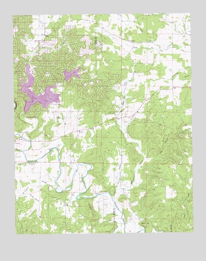
Myron, AR USGS Topographic Map
Click on map above to begin viewing in our Map Viewer.

This topographic map contains these locations and features:
Feature Name Type Latitude Longitude GNIS ID View Map
Baker CemeteryCemeteryN36.1265°W91.6874°46032View Map
Baker HillSummitN36.1306°W91.6585°57304View Map
BallardPopulated PlaceN36.2351°W91.6688°57319View Map
Bates CemeteryCemeteryN36.1948°W91.7196°46148View Map
Bens CreekStreamN36.1806°W91.7454°46388View Map
City of Horseshoe BendCivilN36.2216°W91.7398°2404731View Map
Crown LakeReservoirN36.2001°W91.7468°79651View Map
Crown Lake DamDamN36.2001°W91.7468°79650View Map
Davidson HillSummitN36.1362°W91.6976°57626View Map
DayPopulated PlaceN36.2387°W91.7276°56985View Map
Diamond LakeReservoirN36.2020°W91.7322°79643View Map
Diamond Lake DamDamN36.2084°W91.7235°79642View Map
Godwin CemeteryCemeteryN36.1559°W91.7037°49469View Map
Hars CreekStreamN36.1445°W91.6818°49916View Map
Hills Chapel CemeteryCemeteryN36.1656°W91.7379°50128View Map
Hinson BranchStreamN36.1490°W91.7418°50148View Map
King HollowValleyN36.1673°W91.6593°50858View Map
Love (historical)Populated PlaceN36.1481°W91.6935°65882View Map
McJunkins BranchStreamN36.1501°W91.7215°51853View Map
MyronPopulated PlaceN36.1837°W91.7057°58234View Map
Myron Baptist ChurchChurchN36.1837°W91.7046°65890View Map
Neely CreekStreamN36.2301°W91.6438°52593View Map
Roberts CemeteryCemeteryN36.1692°W91.7499°54070View Map
Robertson BranchStreamN36.1495°W91.6793°54072View Map
Town BranchStreamN36.1723°W91.7443°45767View Map
Township of JeffersonCivilN36.2085°W91.7263°66703View Map

Note: Coordinates in the location and feature list above are referenced to NAD83 datum.


Copyright (C) 2008-2025 Ryan Niemi / Sunset Dynamics ... All Rights Reserved