TopoQuest Logo
Do you find TopoQuest useful?
Help keep TopoQuest running and adding new maps/features by donating!
Bitcoin:  19c7KJd3qBynnjoSw5npx9KScwjBe4ifkT
Litecoin:  LXs6TkuXGGXo1vDsWCkWVdjQX94eUKd6ui
Home View Maps Find Maps Find Places Resources & Links


Evening Shade, Arkansas Topographic Map

USGS Map Title: Evening Shade, AR
USGS Map MRC: 36091A5
DRG (GeoTIFF) Download: o36091a5.tif


Neighboring USGS Topographic Map Quads:


  Myron, AR  
36091B6
 

  Ash Flat, AR  
36091B5
 

  Sitka, AR  
36091B4
 

  Sidney, AR  
36091A6
 

  Evening Shade, AR  
36091A5
 

  Poughkeepsie, AR  
36091A4
 

  Sandtown, AR  
35091H6
 

  Cave City, AR  
35091H5
 

  Grange, AR  
35091H4


Map MRC Location:

N37°
W92°
N37°
W91°
H8 H7 H6 H5 H4 H3 H2 H1
G8 G7 G6 G5 G4 G3 G2 G1
F8 F7 F6 F5 F4 F3 F2 F1
E8 E7 E6 E5 E4 E3 E2 E1
D8 D7 D6 D5 D4 D3 D2 D1
C8 C7 C6 C5 C4 C3 C2 C1
B8 B7 B6 B5 B4 B3 B2 B1
A8 A7 A6 A5 A4 A3 A2 A1
N36°
W92°
N36°
W91°

Evening Shade, AR USGS 1:24K Topographic Map Preview:
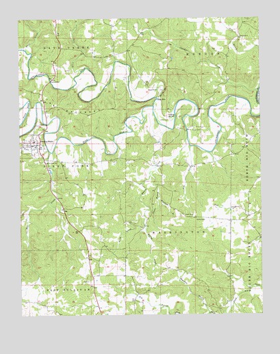
Evening Shade, AR USGS Topographic Map
Click on map above to begin viewing in our Map Viewer.

This topographic map contains these locations and features:
Feature Name Type Latitude Longitude GNIS ID View Map
Amateur (historical)Populated PlaceN36.0167°W91.5362°78950View Map
Balboa (historical)Populated PlaceN36.0326°W91.5004°66150View Map
Barnes CemeteryCemeteryN36.0778°W91.5315°46104View Map
Blue HoleBayN36.0909°W91.5538°46748View Map
City of Evening ShadeCivilN36.0703°W91.6221°2403582View Map
Dry BranchStreamN36.0001°W91.5426°48632View Map
Duck PondLakeN36.0950°W91.5535°74807View Map
Evening ShadePopulated PlaceN36.0717°W91.6193°78954View Map
Evening Shade CemeteryCemeteryN36.0653°W91.6071°48936View Map
Evening Shade Elementary SchoolSchoolN36.0727°W91.6172°66157View Map
Evening Shade High SchoolSchoolN36.0734°W91.6177°66158View Map
Evening Shade Police DepartmentBuildingN36.0719°W91.6191°2118635View Map
Evening Shade Volunteer Fire StationBuildingN36.0719°W91.6154°2116415View Map
Flat CreekStreamN36.0715°W91.5371°49096View Map
Flatwoods ChurchChurchN36.1173°W91.5099°49123View Map
Fore CemeteryCemeteryN36.0987°W91.5599°49161View Map
Hamilton BranchStreamN36.0006°W91.5265°49800View Map
Lafferty CemeteryCemeteryN36.0823°W91.5485°50935View Map
Lafferty SpringsSpringN36.0834°W91.5474°51385View Map
Lave CreekStreamN36.1034°W91.5924°51000View Map
Mill CreekStreamN36.0690°W91.6093°52027View Map
Mirey BranchStreamN36.0917°W91.5540°52097View Map
North Prong Whaley CreekStreamN36.0420°W91.5612°52837View Map
Piney ForkStreamN36.0878°W91.5557°53485View Map
Powell CemeteryCemeteryN36.0423°W91.5360°53740View Map
Powell ChapelChurchN36.0401°W91.5335°53742View Map
Sloan CreekStreamN36.1120°W91.6213°54911View Map
The BackboneRidgeN36.0856°W91.5988°55504View Map
Town BranchStreamN36.0703°W91.6107°55618View Map
Township of Sullivan (historical)CivilN36.0015°W91.6243°66378View Map
Township of WashingtonCivilN36.0362°W91.5427°69158View Map
Vance BranchStreamN36.0001°W91.5476°55884View Map
Vance BranchStreamN36.0623°W91.5549°55885View Map
Whaley CreekStreamN36.0748°W91.5382°56216View Map
Whitlock BranchStreamN36.0498°W91.5529°56330View Map

Note: Coordinates in the location and feature list above are referenced to NAD83 datum.


Copyright (C) 2008-2025 Ryan Niemi / Sunset Dynamics ... All Rights Reserved