TopoQuest Logo
Do you find TopoQuest useful?
Help keep TopoQuest running and adding new maps/features by donating!
Bitcoin:  19c7KJd3qBynnjoSw5npx9KScwjBe4ifkT
Litecoin:  LXs6TkuXGGXo1vDsWCkWVdjQX94eUKd6ui
Home View Maps Find Maps Find Places Resources & Links


Pennington, Alabama Topographic Map

USGS Map Title: Pennington, AL
USGS Map MRC: 32088B1
DRG (GeoTIFF) Download: o32088b1.tif


Neighboring USGS Topographic Map Quads:


  Gaston, AL  
32088C2
 

  Whitfield, AL  
32088C1
 

  Myrtlewood North, AL  
32087C8
 

  Jachin, AL  
32088B2
 

  Pennington, AL  
32088B1
 

  Myrtlewood South, AL  
32087B8
 

  Butler, AL  
32088A2
 

  Putnam, AL  
32088A1
 

  Nanafalia, AL  
32087A8


Map MRC Location:

N33°
W89°
N33°
W88°
H8 H7 H6 H5 H4 H3 H2 H1
G8 G7 G6 G5 G4 G3 G2 G1
F8 F7 F6 F5 F4 F3 F2 F1
E8 E7 E6 E5 E4 E3 E2 E1
D8 D7 D6 D5 D4 D3 D2 D1
C8 C7 C6 C5 C4 C3 C2 C1
B8 B7 B6 B5 B4 B3 B2 B1
A8 A7 A6 A5 A4 A3 A2 A1
N32°
W89°
N32°
W88°

Pennington, AL USGS 1:24K Topographic Map Preview:
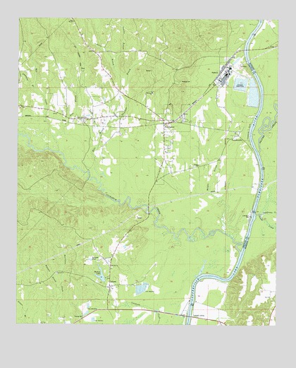
Pennington, AL USGS Topographic Map
Click on map above to begin viewing in our Map Viewer.

This topographic map contains these locations and features:
Feature Name Type Latitude Longitude GNIS ID View Map
Aces Hunting ClubLocaleN32.1910°W88.0842°139940View Map
Barrons (historical)Populated PlaceN32.1288°W88.0028°1730241View Map
Barrons LandingLocaleN32.1660°W88.0117°137569View Map
Beaver CreekStreamN32.1957°W88.0092°113733View Map
Beaver Creek Landing (historical)LocaleN32.1949°W88.0083°137571View Map
Breckenridge Landing (historical)LocaleN32.2482°W88.0078°137579View Map
C A Ezell DamDamN32.2168°W88.0117°130305View Map
C A Ezell Fish HatcheryLocaleN32.1468°W88.0617°130211View Map
C A Ezell Fish Hatchery DamDamN32.1468°W88.0617°130212View Map
Camp BranchStreamN32.2043°W88.0870°115437View Map
Cherokee (historical)LocaleN32.1738°W88.0114°139977View Map
Choctaw CityPopulated PlaceN32.2090°W88.0942°116078View Map
Chucksey BranchStreamN32.2199°W88.1164°116107View Map
Coffeeville LakeReservoirN32.1450°W88.0299°116358View Map
Compton (historical)LocaleN32.1351°W88.0420°139987View Map
Compton LandingLocaleN32.1290°W88.0403°156206View Map
DeasPopulated PlaceN32.2293°W88.0972°156259View Map
Deas BranchStreamN32.2018°W88.1086°117182View Map
Double CreekStreamN32.1701°W88.0103°117421View Map
Ebenezer CemeteryCemeteryN32.2193°W88.0606°1805513View Map
Ebenzer Baptist ChurchChurchN32.2199°W88.0622°117841View Map
Eureka LandingLocaleN32.1407°W88.0406°139996View Map
Ezell CampLocaleN32.1335°W88.0422°139997View Map
Final Mill Effluent Treatment PonReservoirN32.2189°W88.0120°130304View Map
G B Chaneys LandingLocaleN32.1532°W88.0181°163246View Map
Hill BranchStreamN32.1782°W88.0336°140017View Map
Hopewell Baptist ChurchChurchN32.1460°W88.1059°120370View Map
Hopewell BranchStreamN32.1390°W88.1036°120356View Map
Hopewell CemeteryCemeteryN32.1457°W88.1056°1805532View Map
Horn BranchStreamN32.1829°W88.0861°120395View Map
James BluffCliffN32.2329°W88.0409°140029View Map
Julian Waters Lake DamDamN32.1418°W88.0850°130204View Map
Kemp BranchStreamN32.2340°W88.0153°140031View Map
Kemps LandingLocaleN32.2410°W88.0159°140032View Map
Landrums CreekStreamN32.1704°W88.0075°151985View Map
LavacaPopulated PlaceN32.1404°W88.0800°152000View Map
Little Zion African Methodist Episcopal Zion ChurchChurchN32.1490°W88.0806°152123View Map
Lock Number Two (historical)LocaleN32.1693°W88.0111°140041View Map
Lock Number Two ParkParkN32.1699°W88.0128°152135View Map
Lotts Ferry (historical)CrossingN32.1357°W88.0411°140042View Map
Manns Old Landing (historical)LocaleN32.1807°W88.0070°137629View Map
Marengo ChuteChannelN32.2265°W88.0100°137630View Map
Mill CreekStreamN32.1954°W88.1059°122788View Map
Millwood CemeteryCemeteryN32.2246°W88.0483°122854View Map
Morgan BranchStreamN32.1629°W88.0253°123038View Map
Morgan BranchStreamN32.1274°W88.0558°140062View Map
Moss Horn Hunting ClubLocaleN32.2368°W88.1089°154719View Map
Mulberry CreekStreamN32.1754°W88.0761°140072View Map
Murphys BluffCliffN32.1960°W88.0114°163247View Map
Murphys Ferry (historical)CrossingN32.1938°W88.0100°140073View Map
NaheolaPopulated PlaceN32.2276°W88.0289°156766View Map
Naheola Landing (historical)LocaleN32.2379°W88.0161°140074View Map
Nanafalia BluffCliffN32.1446°W88.0197°137643View Map
Nanafalia LandingLocaleN32.1460°W88.0195°137644View Map
Norwood PondReservoirN32.1516°W88.0896°124034View Map
PenningtonPopulated PlaceN32.2071°W88.0561°124588View Map
Pennington Post OfficePost OfficeN32.2026°W88.0550°2789109View Map
Pennington Volunteer Fire DepartmentBuildingN32.2108°W88.0568°2691252View Map
Perry BranchStreamN32.2218°W88.0756°124621View Map
Red House CemeteryCemeteryN32.1421°W88.0872°154720View Map
Scanlin BranchStreamN32.2301°W88.0803°126456View Map
Thompkinsville African Methodist Episcopal Zion ChurchChurchN32.2040°W88.0203°150899View Map
Threemile BranchStreamN32.2021°W88.0861°127947View Map
Tompkins BluffCliffN32.2049°W88.0139°153701View Map
TompkinsvillePopulated PlaceN32.2032°W88.0203°128014View Map
Town of PenningtonCivilN32.1967°W88.0558°2407098View Map
Trinity United Methodist ChurchChurchN32.1960°W88.0550°153720View Map
Tuckabum CreekStreamN32.1549°W88.0172°153731View Map
Watters LakeReservoirN32.1449°W88.0842°153902View Map
William B Crumpton BridgeBridgeN32.1285°W88.0417°137680View Map
Zion ChurchChurchN32.1365°W88.0031°155316View Map

Note: Coordinates in the location and feature list above are referenced to NAD83 datum.


Copyright (C) 2008-2025 Ryan Niemi / Sunset Dynamics ... All Rights Reserved