TopoQuest Logo
Do you find TopoQuest useful?
Help keep TopoQuest running and adding new maps/features by donating!
Bitcoin:  19c7KJd3qBynnjoSw5npx9KScwjBe4ifkT
Litecoin:  LXs6TkuXGGXo1vDsWCkWVdjQX94eUKd6ui
Home View Maps Find Maps Find Places Resources & Links


Myrtlewood South, Alabama Topographic Map

USGS Map Title: Myrtlewood South, AL
USGS Map MRC: 32087B8
DRG (GeoTIFF) Download: o32087b8.tif


Neighboring USGS Topographic Map Quads:


  Whitfield, AL  
32088C1
 

  Myrtlewood North, AL  
32087C8
 

  Linden, AL  
32087C7
 

  Pennington, AL  
32088B1
 

  Myrtlewood South, AL  
32087B8
 

  Miller, AL  
32087B7
 

  Putnam, AL  
32088A1
 

  Nanafalia, AL  
32087A8
 

  Sweet Water, AL  
32087A7


Map MRC Location:

N33°
W88°
N33°
W87°
H8 H7 H6 H5 H4 H3 H2 H1
G8 G7 G6 G5 G4 G3 G2 G1
F8 F7 F6 F5 F4 F3 F2 F1
E8 E7 E6 E5 E4 E3 E2 E1
D8 D7 D6 D5 D4 D3 D2 D1
C8 C7 C6 C5 C4 C3 C2 C1
B8 B7 B6 B5 B4 B3 B2 B1
A8 A7 A6 A5 A4 A3 A2 A1
N32°
W88°
N32°
W87°

Myrtlewood South, AL USGS 1:24K Topographic Map Preview:
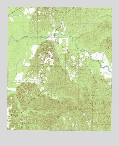
Myrtlewood South, AL USGS Topographic Map
Click on map above to begin viewing in our Map Viewer.

This topographic map contains these locations and features:
Feature Name Type Latitude Longitude GNIS ID View Map
Beaver Creek Baptist CemeteryCemeteryN32.1718°W87.8789°1867941View Map
Beaver Creek ChurchChurchN32.1713°W87.8803°113736View Map
Beecomb BranchStreamN32.1835°W87.8756°113829View Map
CampgroundPopulated PlaceN32.1915°W87.9561°1805612View Map
Campground CemeteryCemeteryN32.1918°W87.9561°1867945View Map
Campground ChurchChurchN32.1924°W87.9570°115509View Map
Community CemeteryCemeteryN32.1871°W87.9136°137588View Map
Cow CreekStreamN32.2207°W87.9247°137589View Map
Crooked Branch Hunting ClubLocaleN32.1976°W87.9850°137590View Map
GenevaPopulated PlaceN32.1590°W87.9639°1730247View Map
Geneva Presbyterian ChurchChurchN32.1579°W87.9636°118891View Map
Geneva Presbyterian Church CemeteryCemeteryN32.1585°W87.9631°1805613View Map
Half AcrePopulated PlaceN32.1946°W87.9122°156444View Map
Half Acre ChurchChurchN32.1940°W87.9128°137610View Map
Holiness ChurchChurchN32.1863°W87.9006°155101View Map
Hope ChurchChurchN32.1829°W87.9600°154780View Map
Howell CemeteryCemeteryN32.1404°W87.9953°120480View Map
Iron BridgeBridgeN32.2007°W87.9014°1730252View Map
James ChapelChurchN32.2046°W87.9267°120806View Map
James Chapel CemeteryCemeteryN32.2040°W87.9258°1867927View Map
Little Beaver CreekStreamN32.2215°W87.9456°121702View Map
Mayton (historical)LocaleN32.1493°W87.9011°137634View Map
Mill CreekStreamN32.1740°W87.9783°122765View Map
Myrtlewood Post OfficePost OfficeN32.2499°W87.9490°168784View Map
Noland Store (historical)LocaleN32.1676°W87.9570°137645View Map
North Double CreekStreamN32.1446°W87.9853°123991View Map
South Double CreekStreamN32.1446°W87.9853°127117View Map

Note: Coordinates in the location and feature list above are referenced to NAD83 datum.


Copyright (C) 2008-2025 Ryan Niemi / Sunset Dynamics ... All Rights Reserved