TopoQuest Logo
Do you find TopoQuest useful?
Help keep TopoQuest running and adding new maps/features by donating!
Bitcoin:  19c7KJd3qBynnjoSw5npx9KScwjBe4ifkT
Litecoin:  LXs6TkuXGGXo1vDsWCkWVdjQX94eUKd6ui
Home View Maps Find Maps Find Places Resources & Links


Napier Pond, Georgia Topographic Map

USGS Map Title: Napier Pond, GA
USGS Map MRC: 32083H2
DRG (GeoTIFF) Download: o32083h2.tif


Neighboring USGS Topographic Map Quads:


  Browns Crossing, GA  
33083A3
 

  Milledgeville, GA  
33083A2
 

  Friendship, GA  
33083A1
 

  Gordon, GA  
32083H3
 

  Napier Pond, GA  
32083H2
 

  Gumm Pond, GA  
32083H1
 

  Massey Hill, GA  
32083G3
 

  Irwinton, GA  
32083G2
 

  Toomsboro, GA  
32083G1


Map MRC Location:

N33°
W84°
N33°
W83°
H8 H7 H6 H5 H4 H3 H2 H1
G8 G7 G6 G5 G4 G3 G2 G1
F8 F7 F6 F5 F4 F3 F2 F1
E8 E7 E6 E5 E4 E3 E2 E1
D8 D7 D6 D5 D4 D3 D2 D1
C8 C7 C6 C5 C4 C3 C2 C1
B8 B7 B6 B5 B4 B3 B2 B1
A8 A7 A6 A5 A4 A3 A2 A1
N32°
W84°
N32°
W83°

Napier Pond, GA USGS 1:24K Topographic Map Preview:
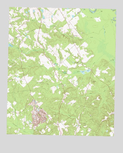
Napier Pond, GA USGS Topographic Map
Click on map above to begin viewing in our Map Viewer.

This topographic map contains these locations and features:
Feature Name Type Latitude Longitude GNIS ID View Map
Beckham LakeReservoirN32.9966°W83.2210°340620View Map
Beckham Lake DamDamN32.9951°W83.2215°340619View Map
Bentley CemeteryCemeteryN32.8835°W83.1649°311095View Map
Betty LakeLakeN32.9976°W83.1427°311259View Map
Blackkiln BranchStreamN32.8771°W83.2213°334925View Map
Bloodworths Store (historical)LocaleN32.9349°W83.1940°334926View Map
Bull BranchStreamN32.9346°W83.1777°312012View Map
Byington CemeteryCemeteryN32.9596°W83.2374°354926View Map
Carr Corners (historical)Populated PlaceN32.9188°W83.2235°334927View Map
Council CemeteryCemeteryN32.9663°W83.1729°355331View Map
Davis CemeteryCemeteryN32.8754°W83.2090°346787View Map
Dead RiverGapN32.9882°W83.1296°313380View Map
Eady PondReservoirN32.9443°W83.1927°313754View Map
Fairchild CemeteryCemeteryN32.8949°W83.2429°314033View Map
Forestry Pond Dam Number OneDamN32.9885°W83.2082°336330View Map
Forestry Pond Dam Number TwoDamN32.9985°W83.2115°336332View Map
Forestry Pond Number TwoReservoirN32.9971°W83.2112°336333View Map
Georgia State Hospital LakeReservoirN32.9908°W83.2095°336331View Map
Georgia State Hospital Lake WestReservoirN32.9922°W83.2291°340478View Map
Georgia State Hospital Lake West DamDamN32.9935°W83.2282°340477View Map
Goldens Mill (historical)Populated PlaceN32.9360°W83.1818°334928View Map
Goldens PondReservoirN32.9369°W83.1834°314674View Map
Hillhouse HillSummitN32.9285°W83.1504°331987View Map
Hodges Lake DamDamN32.9613°W83.2446°340810View Map
Hollinshead PondReservoirN32.9924°W83.1745°340638View Map
Hollinshead Pond DamDamN32.9918°W83.1749°340637View Map
Hospital Lake Number OneReservoirN32.9919°W83.1995°336329View Map
Hospital Lake Number One DamDamN32.9901°W83.1999°336328View Map
Johns BridgeBridgeN32.9579°W83.2085°334930View Map
Jones PondReservoirN32.9711°W83.2285°340813View Map
Jones Pond DamDamN32.9701°W83.2282°340812View Map
Laurel BranchStreamN32.9401°W83.1910°316666View Map
Laurel Branch ChurchChurchN32.9399°W83.2332°316668View Map
Little Black CreekStreamN32.9574°W83.1374°316956View Map
Long LakeLakeN32.9760°W83.1386°317374View Map
Lords BranchStreamN32.8829°W83.2371°317408View Map
Macedonia CemeteryCemeteryN32.9235°W83.1854°346800View Map
Macedonia ChurchChurchN32.9243°W83.1852°317549View Map
Mount Carmel (historical)Populated PlaceN32.9024°W83.2124°352080View Map
Mount Nebo CemeteryCemeteryN32.8865°W83.1585°346804View Map
Mount Nebo ChurchChurchN32.8871°W83.1582°318711View Map
Mount PleasantPopulated PlaceN32.9832°W83.2471°334777View Map
Mount Pleasant Academy (historical)SchoolN32.9018°W83.2118°346806View Map
Mount Pleasant Baptist ChurchyardCemeteryN32.9832°W83.2465°1986015View Map
Mount Pleasant ChurchChurchN32.9018°W83.2124°318846View Map
Mount Pleasant ChurchChurchN32.9826°W83.2474°318848View Map
Napier PondReservoirN32.9389°W83.1596°319205View Map
Napier Pond DamDamN32.9401°W83.1554°336125View Map
Nunn-Wheeler CemeteryCemeteryN32.9474°W83.1665°319722View Map
Nunn-Wheeler Church (historical)ChurchN32.9468°W83.1677°346807View Map
Parker Hill ChurchChurchN32.8951°W83.1529°320220View Map
Parker Springs ChurchChurchN32.9263°W83.2118°320224View Map
Peeler ChapelChurchN32.9682°W83.2338°320341View Map
Price-council-Carr CemeteryCemeteryN32.9582°W83.1604°321142View Map
Scott LakeReservoirN32.9962°W83.2268°336335View Map
Scott Lake DamDamN32.9951°W83.2265°336334View Map
Second Macedonia ChurchChurchN32.9732°W83.1738°322693View Map
Snow Hil CemeteriesCemeteryN32.9276°W83.2471°352299View Map
Snow Hill ChurchChurchN32.9285°W83.2465°323200View Map
Snow Hill School (historical)SchoolN32.9274°W83.2468°334935View Map
Stubbs CemeteryCemeteryN32.8768°W83.1468°323703View Map
Temples CemeteryCemeteryN32.8957°W83.1913°323988View Map
Thompson BranchStreamN32.9401°W83.1913°324097View Map
Thompson School (historical)SchoolN32.9476°W83.1860°334937View Map
Trilby School (historical)SchoolN32.9815°W83.1796°334784View Map
White LakeLakeN32.9996°W83.1637°325160View Map
WVKX-FM (Irwinton)TowerN32.8801°W83.1852°352710View Map
Youngblood Corners (historical)Populated PlaceN32.8857°W83.1902°334941View Map

Note: Coordinates in the location and feature list above are referenced to NAD83 datum.


Copyright (C) 2008-2024 Ryan Niemi / Sunset Dynamics ... All Rights Reserved