TopoQuest Logo
Do you find TopoQuest useful?
Help keep TopoQuest running and adding new maps/features by donating!
Bitcoin:  19c7KJd3qBynnjoSw5npx9KScwjBe4ifkT
Litecoin:  LXs6TkuXGGXo1vDsWCkWVdjQX94eUKd6ui
Home View Maps Find Maps Find Places Resources & Links


Nassa Point, Washington Topographic Map

USGS Map Title: Nassa Point, WA
USGS Map MRC: 46123B3
DRG (GeoTIFF) Download: o46123b3.tif


Neighboring USGS Topographic Map Quads:


  Skamokawa, WA  
46123C4
 

  Skamokawa Pass, WA  
46123C3
 

  Elochoman Lake, WA  
46123C2
 

  Cathlamet, WA  
46123B4
 

  Nassa Point, WA  
46123B3
 

  Oak Point, WA  
46123B2
 

  Nicolai Mountain, OR  
46123A4
 

  Marshland, OR  
46123A3
 

  Clatskanie, OR  
46123A2


Map MRC Location:

N47°
W124°
N47°
W123°
H8 H7 H6 H5 H4 H3 H2 H1
G8 G7 G6 G5 G4 G3 G2 G1
F8 F7 F6 F5 F4 F3 F2 F1
E8 E7 E6 E5 E4 E3 E2 E1
D8 D7 D6 D5 D4 D3 D2 D1
C8 C7 C6 C5 C4 C3 C2 C1
B8 B7 B6 B5 B4 B3 B2 B1
A8 A7 A6 A5 A4 A3 A2 A1
N46°
W124°
N46°
W123°

Nassa Point, WA USGS 1:24K Topographic Map Preview:
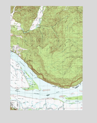
Nassa Point, WA USGS Topographic Map
Click on map above to begin viewing in our Map Viewer.

This topographic map contains these locations and features:
Feature Name Type Latitude Longitude GNIS ID View Map
Abe CreekStreamN46.1812°W123.3487°1502925View Map
Abe Creek QuarryMineN46.1875°W123.3474°2605628View Map
Beaver CreekStreamN46.2232°W123.3312°1503253View Map
Beaver Creek State Fish HatcheryLocaleN46.2257°W123.3276°1533277View Map
Browns IslandIslandN46.1737°W123.3560°1514722View Map
Cape HornSummitN46.1521°W123.2873°1512063View Map
Cathlamet ChannelChannelN46.1882°W123.3657°1503863View Map
Cathlamet DivisionCivilN46.1914°W123.3113°1939467View Map
Cathlamet Recreational Vehicle ParkLocaleN46.1974°W123.3694°2608232View Map
Cathlamet Seventh Day Adventist ChurchChurchN46.1955°W123.3627°2609360View Map
Cooper IslandIslandN46.1498°W123.2518°1848445View Map
Cooper PointCapeN46.1582°W123.2543°1504133View Map
Cougar CreekStreamN46.1843°W123.3440°1509923View Map
Cougar Creek ReservoirReservoirN46.1942°W123.3545°1532780View Map
Cougar Creek Reservoir DamDamN46.1948°W123.3546°1532779View Map
Cut-Off SloughGutN46.1540°W123.3426°1509986View Map
Driscoll RangeChannelN46.1462°W123.3693°1120094View Map
East CathlametPopulated PlaceN46.1968°W123.3668°1852941View Map
East Cathlamet Census Designated PlaceCensusN46.1968°W123.3580°2408703View Map
Eureka Lower ChannelChannelN46.1507°W123.2637°1135926View Map
FlandersvillePopulated PlaceN46.1540°W123.2957°1509917View Map
Gilbertson SloughStreamN46.1721°W123.3657°1505131View Map
HarperLocaleN46.2359°W123.3712°1509937View Map
Hay MountainSummitN46.2076°W123.2707°1509919View Map
Hunter CreekStreamN46.2034°W123.2676°1509920View Map
Indian Village Mobile Home ParkPopulated PlaceN46.1968°W123.3705°2607155View Map
Jackson InletGutN46.1665°W123.3507°1509985View Map
Jackson IslandIslandN46.1673°W123.3471°1531241View Map
Jones BeachBeachN46.1393°W123.3096°1135010View Map
Kelli SloughGutN46.1271°W123.3235°1135007View Map
Kerry SloughLakeN46.1261°W123.3547°1135009View Map
Lower Elochoman Census Designated PlaceCensusN46.2185°W123.3698°2585000View Map
Ludviksen SloughGutN46.1346°W123.3498°1135011View Map
NassaLocaleN46.1662°W123.3296°1511941View Map
Nassa PointCapeN46.1640°W123.3276°1506932View Map
Net Rack SloughGutN46.1512°W123.3485°1510086View Map
Pancake PointCapeN46.1507°W123.3673°1507274View Map
Randa SloughGutN46.1309°W123.3332°1135008View Map
Saint James Family CenterChurchN46.1945°W123.3701°2609110View Map
State CampPopulated PlaceN46.2498°W123.3212°1509681View Map
Sturgeon Pen SloughStreamN46.1723°W123.3618°1508790View Map
Upper Elochoman Census Designated PlaceCensusN46.2403°W123.3246°2585048View Map
Upper Elochoman ValleyValleyN46.2209°W123.3435°1513257View Map
Wallace IslandIslandN46.1407°W123.2537°1128607View Map
Wallace SloughStreamN46.1412°W123.2973°1128609View Map
WaterfordPopulated PlaceN46.1532°W123.2679°1509918View Map
West CreekStreamN46.1262°W123.3604°1128823View Map
WestportPopulated PlaceN46.1326°W123.3748°1136894View Map
Westport Boat RampLocaleN46.1368°W123.3729°2058197View Map
Westport Census Designated PlaceCensusN46.1304°W123.3714°2611784View Map
Westport ChannelChannelN46.1457°W123.2901°1128924View Map
Westport Post OfficePost OfficeN46.1326°W123.3748°1166163View Map
Westport Sewer Service District Sewage Treatment PlantLocaleN46.1347°W123.3743°2660701View Map
Westport Turn and RangeChannelN46.1432°W123.3237°1135980View Map
Westport Turn and RangeChannelN46.1468°W123.3526°1513337View Map
Whiskey Joe SloughGutN46.1382°W123.3590°1135012View Map
Whites IslandIslandN46.1554°W123.3351°1509896View Map

Note: Coordinates in the location and feature list above are referenced to NAD83 datum.


Copyright (C) 2008-2024 Ryan Niemi / Sunset Dynamics ... All Rights Reserved