TopoQuest Logo
Do you find TopoQuest useful?
Help keep TopoQuest running and adding new maps/features by donating!
Bitcoin:  19c7KJd3qBynnjoSw5npx9KScwjBe4ifkT
Litecoin:  LXs6TkuXGGXo1vDsWCkWVdjQX94eUKd6ui
Home View Maps Find Maps Find Places Resources & Links


Oak Point, Washington Topographic Map

USGS Map Title: Oak Point, WA
USGS Map MRC: 46123B2
DRG (GeoTIFF) Download: o46123b2.tif


Neighboring USGS Topographic Map Quads:


  Skamokawa Pass, WA  
46123C3
 

  Elochoman Lake, WA  
46123C2
 

  Abernathy Mountain, WA  
46123C1
 

  Nassa Point, WA  
46123B3
 

  Oak Point, WA  
46123B2
 

  Coal Creek, WA  
46123B1
 

  Marshland, OR  
46123A3
 

  Clatskanie, OR  
46123A2
 

  Delena, OR  
46123A1


Map MRC Location:

N47°
W124°
N47°
W123°
H8 H7 H6 H5 H4 H3 H2 H1
G8 G7 G6 G5 G4 G3 G2 G1
F8 F7 F6 F5 F4 F3 F2 F1
E8 E7 E6 E5 E4 E3 E2 E1
D8 D7 D6 D5 D4 D3 D2 D1
C8 C7 C6 C5 C4 C3 C2 C1
B8 B7 B6 B5 B4 B3 B2 B1
A8 A7 A6 A5 A4 A3 A2 A1
N46°
W124°
N46°
W123°

Oak Point, WA USGS 1:24K Topographic Map Preview:
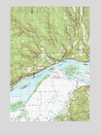
Oak Point, WA USGS Topographic Map
Click on map above to begin viewing in our Map Viewer.

This topographic map contains these locations and features:
Feature Name Type Latitude Longitude GNIS ID View Map
Abernathy Assembly of God ChurchChurchN46.2075°W123.1523°2608677View Map
Abernathy CemeteryCemeteryN46.1907°W123.1718°1502928View Map
Abernathy Fish Technology CenterParkN46.2263°W123.1478°2765178View Map
Abernathy PointCapeN46.1909°W123.1676°1502929View Map
Abernethy CreekStreamN46.1915°W123.1673°1534567View Map
Anunde IslandIslandN46.1326°W123.2296°1117015View Map
Beaver CreekStreamN46.1348°W123.1685°1117435View Map
Beaver Generating PlantLocaleN46.1729°W123.1790°1637994View Map
Beaver Power PlantLocaleN46.1732°W123.1766°2697247View Map
Beaver SloughStreamN46.1394°W123.2318°1117455View Map
Bradbury Post Office (historical)Post OfficeN46.1690°W123.1471°1164233View Map
Bradbury SloughGutN46.1734°W123.1512°1158139View Map
Bunker HillPopulated PlaceN46.2023°W123.1387°1510848View Map
Bunker Hill CemeteryCemeteryN46.1993°W123.1420°1510023View Map
Bunker Hill GrangeBuildingN46.2162°W123.1318°1534475View Map
Cameron CreekStreamN46.1965°W123.1618°1503731View Map
Cascade Grain Products Ethanol Production FacilityLocaleN46.1789°W123.1722°2697249View Map
Clatskanie Rural Fire Quincy StationBuildingN46.1565°W123.1521°2576785View Map
Cowlitz 2 Fire and Rescue Station 26 Bunker HillBuildingN46.1935°W123.1483°2619504View Map
Cries CreekStreamN46.1679°W123.1318°1132330View Map
Crims IslandIslandN46.1757°W123.1446°1119548View Map
Dobbins SloughGutN46.1518°W123.1665°1637997View Map
Eagle CliffPopulated PlaceN46.1709°W123.2343°1510924View Map
Eureka BarBarN46.1637°W123.2290°1162765View Map
Eureka ChannelChannelN46.1690°W123.2282°1504772View Map
Eureka Upper ChannelChannelN46.1648°W123.2346°1135922View Map
Eureka Upper ChannelChannelN46.1662°W123.2337°1513336View Map
Grasseth CemeteryCemeteryN46.1823°W123.2154°1510024View Map
Gull IslandIslandN46.1854°W123.1540°1121481View Map
Gull Island Turn and ChannelChannelN46.1884°W123.1554°1121482View Map
InglisPopulated PlaceN46.1265°W123.1651°1136407View Map
Inglis Post Office (historical)Post OfficeN46.1265°W123.1651°1165438View Map
Inglis Station (historical)LocaleN46.1304°W123.1754°1167938View Map
John SloughGutN46.1651°W123.1460°1637996View Map
Kinnunen CutGutN46.1282°W123.2262°1637999View Map
Larson SloughStreamN46.1498°W123.2193°1132322View Map
Locoda (historical)LocaleN46.1623°W123.1473°1637851View Map
Marshland DivisionCensusN46.1434°W123.2393°1938055View Map
McLean SloughStreamN46.1340°W123.1896°1124001View Map
Memaloose RockBarN46.1909°W123.1673°1514747View Map
Michigan SloughGutN46.1282°W123.1932°1637998View Map
Mill CreekStreamN46.1887°W123.1746°1506692View Map
Mill Creek Truck TrailTrailN46.2307°W123.2107°1506699View Map
North Fork Mill CreekStreamN46.2204°W123.2168°1507060View Map
North Fork Stewart CreekStreamN46.1290°W123.1540°1132324View Map
Oak PointPopulated PlaceN46.1909°W123.1887°1512521View Map
Oak Point (historical)CapeN46.1818°W123.1790°1851728View Map
Oak Point CemeteryCemeteryN46.1887°W123.1898°1510376View Map
Oak Point ChannelChannelN46.1779°W123.1971°1135923View Map
Oak Point Community ChurchChurchN46.1920°W123.1881°2609621View Map
Point AdamsCapeN46.1382°W123.2304°1135144View Map
Port WestwardLocaleN46.1773°W123.1798°1637995View Map
Port Westward Generating ProjectLocaleN46.1687°W123.1481°2697274View Map
Port Westward SpurLocaleN46.1615°W123.1437°1637826View Map
Poysky SloughGutN46.1665°W123.2026°1637993View Map
QuincyPopulated PlaceN46.1437°W123.1601°1125753View Map
Quincy Post Office (historical)Post OfficeN46.1437°W123.1601°1165829View Map
Quincy ReservoirReservoirN46.1354°W123.1343°1162766View Map
Quincy School (historical)SchoolN46.1343°W123.1596°1125754View Map
Quinn Post Office (historical)Post OfficeN46.1665°W123.1846°1164621View Map
Slide CreekStreamN46.2090°W123.1515°1508413View Map
South Fork Mill CreekStreamN46.1959°W123.1929°1509921View Map
Spruce CreekStreamN46.1946°W123.2040°1509922View Map
Stella Lutheran ChapelChurchN46.2165°W123.1275°2609108View Map
Stewart CreekStreamN46.1318°W123.1623°1132325View Map
Stewart Hill CemeteryCemeteryN46.1276°W123.1582°1132319View Map
Swampy LakeSwampN46.1742°W123.1912°1132321View Map
Tank CreekStreamN46.1526°W123.1596°1132323View Map
Wiest CreekStreamN46.2332°W123.1468°1509501View Map

Note: Coordinates in the location and feature list above are referenced to NAD83 datum.


Copyright (C) 2008-2024 Ryan Niemi / Sunset Dynamics ... All Rights Reserved